Conecuh County, Alabama
| Conecuh County, Alabama | |
|---|---|
 The Conecuh County Government Center in Evergreen | |
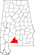 Location in the state of Alabama | |
 Alabama's location in the U.S. | |
| Founded | February 13, 1818 |
| Seat | Evergreen |
| Largest city | Evergreen |
| Area | |
| • Total | 853 sq mi (2,209 km2) |
| • Land | 850 sq mi (2,201 km2) |
| • Water | 2.6 sq mi (7 km2), 0.3% |
| Population | |
| • (2010) | 13,228 |
| • Density | 16/sq mi (6/km²) |
| Congressional district | 2nd |
| Time zone | Central: UTC-6/-5 |
Conecuh County[p] is a county of the U.S. state of Alabama. As of the 2010 census the population was 13,228.[1] Its county seat is Evergreen, Alabama.[2] Its name is believed to be derived from a Creek Indian term meaning "land of cane."
History
The areas along the rivers had been used by varying cultures of indigenous peoples for thousands of years. French and Spanish explorers encountered the historic Creek Indians. Later, British colonial traders developed relationships with the Creek, and several married high-status Creek women. As the tribe has a matrilineal system, children are considered born into their mother's clan and take their status from her family.
During the American Revolutionary War, the Upper Creek chief Alexander McGillvray (whose father was Scots) allied with the British, as he hoped to stop colonial American encroachment. Commissioned a colonel, he used Jean-Antoine Le Clerc, a French adventurer who lived with the Creek for 20 years, as his war chief to lead Creek warriors.
Origin of Murder Creek
Excerpt from Albert James Pickett's History of Alabama, and Incidentally of Georgia and Mississippi, from the Earliest Period (1851)[3]
1788: About this time, a bloody transaction occurred in the territory of the present county of Conecuh. During the revolutionary war, Colonel McGillivray formed an acquaintance with many conspicuous royalists, and, among others, with Colonel Kirkland, of South Carolina. That person was at McGillivray's house, upon the Coosa, in 1788, with his son, his nephew, and several other gentlemen. They were on their way to Pensacola, where they intended to procure passports, and settle in the Spanish province of Louisiana. When they determined to leave his hospitable abode, McGillivray sent his servant [slave] to guide them to Pensacola. The presence of this servant would assure the Indians that they were friends, for it was dangerous to travel without the Chieftain's protection. Colonel Kirkland and his party had much silver in their saddle-bags. Arriving within a mile of a large creek, which flows into the Conecuh, they met a pack-horse party, about sunset, going up to the nation. They had been to Pensacola, on a trading expedition. This party consisted of a Hillabee Indian, who had murdered so many men, that he was called Istillicha, the Man-slayer—a desperate white man, who had fled from the States for the crime of murder, and whom, on account of his activity and ferocity, the Indians called the Cat—and a blood-thirsty negro, named Bob, the property of Sullivan, a Creek trader of the Hillabees. As soon as Colonel Kirkland and his party were out of sight, these scoundrels formed an encampment. The former went on, crossed the creek, and encamped a short distance from the ford, by the side of the trading path. Placing their saddle-bags under their heads, and reclining their guns against a tree, Kirkland and his party fell asleep. At midnight, the bloody wretches from the other side, cautiously came over, and, seizing the guns of Kirkland and his men, killed every one of them, except three negroes, one of whom was the servant of the great Chieftain, as before stated. Dividing the booty, the murderers proceeded to the Creek nation, and, when the horrid affair became known, Colonel McGillivray sent persons in pursuit of them. Cat was arrested; but the others escaped. Milfort was directed to convey the scoundrel to the spot where he had shed the blood of these men, and there to hang him, until he was dead. Upon the journey to that point, Milfort kept him well pinioned, and, every night, secured his legs in temporary stocks, made by cutting notches in pine logs, and clamping them together. Reaching the creek where poor Kirkland and his men were murdered, Cat was suspended to the limb of a tree, the roots of which were still stained with the blood of the unfortunate colonel and his companions. While he was dangling in the air, and kicking in the last agonies, the Frenchman stopped his motions with a pistol ball. Such is the origin of the name "Murder Creek."
Conecuh County was established by European Americans on February 13, 1818. Some of its territory was taken in 1868 by the state legislature during the Reconstruction era to establish Escambia County. In the coastal plain, it was an area of plantations and cotton cultivation in the nineteenth century. It is still quite rural. Thousands of blacks left after 1940 in the Second Great Migration, especially for jobs in industry on the West Coast.
The county was declared a disaster area in September 1979, due to damage from Hurricane Frederic.
The county is mentioned as the birthplace of Theodore Bagwell in the hit television series Prison Break.
Geography
According to the U.S. Census Bureau, the county has a total area of 853 square miles (2,210 km2), of which 850 square miles (2,200 km2) is land and 2.6 square miles (6.7 km2) (0.3%) is water.[4]
Major highways
.svg.png) Interstate 65
Interstate 65 U.S. Highway 31
 U.S. Highway 84
 State Route 41
 State Route 83
Adjacent counties
- Butler County (northeast)
- Covington County (southeast)
- Escambia County (south)
- Monroe County (northwest)
Demographics
| Historical population | |||
|---|---|---|---|
| Census | Pop. | %± | |
| 1820 | 5,713 | — | |
| 1830 | 7,444 | 30.3% | |
| 1840 | 8,197 | 10.1% | |
| 1850 | 9,322 | 13.7% | |
| 1860 | 11,311 | 21.3% | |
| 1870 | 9,574 | −15.4% | |
| 1880 | 12,605 | 31.7% | |
| 1890 | 14,594 | 15.8% | |
| 1900 | 17,514 | 20.0% | |
| 1910 | 21,433 | 22.4% | |
| 1920 | 24,593 | 14.7% | |
| 1930 | 25,429 | 3.4% | |
| 1940 | 25,489 | 0.2% | |
| 1950 | 21,776 | −14.6% | |
| 1960 | 17,762 | −18.4% | |
| 1970 | 15,645 | −11.9% | |
| 1980 | 15,884 | 1.5% | |
| 1990 | 14,054 | −11.5% | |
| 2000 | 14,089 | 0.2% | |
| 2010 | 13,228 | −6.1% | |
| Est. 2013 | 12,887 | −2.6% | |
| U.S. Decennial Census[5] 1790-1960[6] 1900-1990[7] 1990-2000[8] 2010-2013[1] | |||
2010
Whereas according to the 2010 U.S. Census Bureau:
- 51.3% White
- 46.5% Black
- 0.3% Native American
- 0.1% Asian
- 0.0% Native Hawaiian or Pacific Islander
- 1.0% Two or more races
- 1.2% Hispanic or Latino (of any race)
2000
As of the census[9] of 2000, there were 14,089 people, 5,792 households, and 3,938 families residing in the county. The population density was 17 people per square mile (6/km2). There were 7,265 housing units at an average density of 8 per square mile (3/km2). The racial makeup of the county was 55.40% White, 43.55% Black or African American, 0.20% Native American, 0.11% Asian, 0.05% Pacific Islander, 0.09% from other races, and 0.60% from two or more races. 0.72% of the population were Hispanic or Latino of any race.
There were 5,792 households out of which 30.90% had children under the age of 18 living with them, 47.70% were married couples living together, 16.20% had a female householder with no husband present, and 32.00% were non-families. 30.10% of all households were made up of individuals and 13.50% had someone living alone who was 65 years of age or older. The average household size was 2.42 and the average family size was 3.01.
In the county the population was spread out with 25.90% under the age of 18, 8.30% from 18 to 24, 25.80% from 25 to 44, 24.30% from 45 to 64, and 15.80% who were 65 years of age or older. The median age was 38 years. For every 100 females there were 89.80 males. For every 100 females age 18 and over, there were 84.30 males.
The median income for a household in the county was $22,111, and the median income for a family was $31,424. Males had a median income of $28,115 versus $19,350 for females. The per capita income for the county was $12,964. About 21.70% of families and 26.60% of the population were below the poverty line, including 36.10% of those under age 18 and 28.90% of those age 65 or over.
Communities
City
Towns
- Castleberry
- McKenzie (partly in Butler County)
- Repton
Unincorporated communities
Historic sites
Conecuh County has three sites listed on the National Register of Historic Places, the Asa Johnston Farmhouse, Louisville and Nashville Depot, and New Evergreen Commercial Historic District.[10]
See also
- National Register of Historic Places listings in Conecuh County, Alabama
- Properties on the Alabama Register of Landmarks and Heritage in Conecuh County, Alabama
References
[p] - The name "Conecuh" is pronounced "cah-Neck-ah" emphasizing the second syllable.
- ↑ 1.0 1.1 "State & County QuickFacts". United States Census Bureau. Retrieved May 16, 2014.
- ↑ "Find a County". National Association of Counties. Retrieved 2011-06-07.
- ↑ Albert James Pickett (1 June 2000). History of Alabama: And Incidentally of Georgia and Mississippi, from the Earliest Period. Genealogical Publishing Com. pp. 383–384. ISBN 978-0-8063-4989-3. Retrieved 10 July 2013.
- ↑ "US Gazetteer files: 2010, 2000, and 1990". United States Census Bureau. 2011-02-12. Retrieved 2011-04-23.
- ↑ "U.S. Decennial Census". United States Census Bureau. Retrieved May 16, 2014.
- ↑ "Historical Census Browser". University of Virginia Library. Retrieved May 16, 2014.
- ↑ "Population of Counties by Decennial Census: 1900 to 1990". United States Census Bureau. Retrieved May 16, 2014.
- ↑ "Census 2000 PHC-T-4. Ranking Tables for Counties: 1990 and 2000" (PDF). United States Census Bureau. Retrieved May 16, 2014.
- ↑ "American FactFinder". United States Census Bureau. Retrieved 2008-01-31.
- ↑ "National Register Information System". National Register of Historic Places. National Park Service. July 9, 2010.
External links
- Coastal Gateway Regional Economic Development Alliance
- B.F. Riley, History of Conecuh County, (1881)
- The Monthly View Newspaper
 |
Monroe County | Butler County | | |
| |
||||
| ||||
| | ||||
| Escambia County | Covington County |
| |||||||||||||||||||||||||
| ||||||||||||||||||||||||||||||||||
Coordinates: 31°25′32″N 86°59′38″W / 31.42556°N 86.99389°W