Condesuyos Province
| Condesuyos | |
|---|---|
| Province | |
|
Qurupuna volcano, Condesuyos Province | |
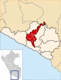 Location of Condesuyos in the Arequipa Region | |
| Country | Peru |
| Region | Arequipa |
| Capital | Chuquibamba |
| Government | |
| • Mayor | Miguel Angel Manchego Llerena (2007) |
| Area | |
| • Total | 6,958.4 km2 (2,686.7 sq mi) |
| Population | |
| • Total | 18,963 |
| • Density | 2.7/km2 (7.1/sq mi) |
| UBIGEO | 0406 |

Condesuyos Province is one of eight provinces in the Arequipa Region of Peru. Its seat is Chuquibamba.
Geography
The Andean Volcanic Belt and the Wansu mountain range traverse the province. Some of the highest peaks of the province are listed below:[1]
Political division
The province is divided into eight districts which are:
- Andaray (Andaray)
- Cayarani (Cayarani)
- Chichas (Chichas)
- Chuquibamba (Chuquibamba)
- Iray (Iray)
- Río Grande (Iquipi)
- Salamanca (Salamanca)
- Yanaquihua (Yanaquihua)
Ethnic groups
The province is inhabited by indigenous citizens of Quechua descent. Spanish, however, is the language which the majority of the population (73.02%) learnt to speak in childhood, 26.37% of the residents started speaking using the Quechua language (2007 Peru Census).[2]
See also
Sources
- ↑ escale.minedu.gob.pe - UGEL map of the La Unión Province (Arequipa Region)
- ↑ inei.gob.pe INEI, Peru, Censos Nacionales 2007
Coordinates: 15°50′21″S 72°39′05″W / 15.839264°S 72.651358°W