Comer Bridge
| B. B. Comer Bridge | |
|---|---|
 | |
| Crosses | Tennessee River |
| Characteristics | |
| Design | Warren Through Steel Truss |
| Total length | 2,143 ft |
| History | |
| Constructed by | Kansas City Bridge Company for the Alabama State Bridge Corporation |
| Opened | 1931 |
| Statistics | |
| Daily traffic | 8,150 (2009) |
| Toll | lifted 1936 |
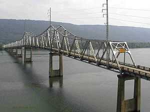
The B. B. Comer Bridge, is the two-lane, 2,143-foot (653 m) long,[1] Warren truss bridge spanning the Tennessee River along Alabama State Route 35 in Scottsboro, Alabama. The bridge is named after Alabama governor Braxton Bragg Comer, who served from 1907 to 1911. Construction of the bridge was carried out by the Kansas City Bridge Company for the Alabama State Bridge Corporation. Its construction commenced in 1929 and was complete by 1931.[2] As of 2013, this is the only remaining bridge of the 15 memorial toll bridges constructed by the Alabama State Bridge Corporation.[3]
By 2007, the aging structure was classified by the Alabama Department of Transportation as being a structurally deficient bridge with an overall rating of 7.7 out of 100.[1] Construction of a replacement bridge commenced in October 2007, and is expected to be completed in late 2015.[2][3] The Comer Bridge is scheduled to be demolished in 2015 although preservation efforts are underway and the Comer Bridge Foundation has been organized.[4] In April 2013, the bridge was named one of the top ten "Top Rated Unique Savable Structures" by BridgeHunter.com.[3] On October 31, 2013, the B. B. Comer Bridge was added to the Alabama Register of Landmarks and Heritage.
See also
References
- ↑ 1.0 1.1 Aldrich, Mazie (August 7, 2007). "B.B Comer differs from collapsed bridge". The Scottsboro Clarion.
- ↑ 2.0 2.1 Brewer, David (October 11, 2007). "Work begins on replacing Comer Bridge". The Huntsville Times.
- ↑ 3.0 3.1 3.2 Benton, Ben (April 8, 2013). "Preservationists eye saving the B.B. Comer Bridge over the Tennessee River". Chattanooga Times Free Press (Chattanooga, TN: WEHCO Media). Retrieved August 11, 2013.
- ↑ Kazak, Kelly (August 10, 2013). "Jackson County residents pledge to fight 'uphill battle' to save historic B.B. Comer Bridge". The Huntsville Times (Huntsville, AL: Advance Publications). Retrieved August 11, 2013.
| |||||||||
Coordinates: 34°38′29″N 85°58′39″W / 34.6414°N 85.9775°W