Colorado State Highway 65
| ||||
|---|---|---|---|---|
| Route information | ||||
| Maintained by CDOT | ||||
| Length: | 61.377 mi[1] (98.777 km) | |||
| Highway system | ||||
|
Colorado State Highways
| ||||

State Highway 65 is a highway in Colorado that crosses the Grand Mesa. The highway along with a road to Lands End Overlook were designated as the Grand Mesa Scenic and Historic Byway in 1996.[2]
Route description
SH 65 runs 61.4 miles (98.8 km), starting at a junction with State Highway 92 east of Delta. The highway heads north, crossing the Gunnison River, through Orchard City and Cedaredge. The highway then enters Grand Mesa National Forest climbing to the top of Grand Mesa. It then drops down the north side of Grand Mesa, ending at a junction with i-70 northeast of Palisade.
Major intersections
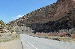
SH 65 near mile marker 58, about 3.5 miles (5.6 km) from Interstate 70
| County | Location | mi | km | Destinations | Notes |
|---|---|---|---|---|---|
| Delta | Saunders | 0.000 | 0.000 | ||
| Mesa | 51.203 | 82.403 | |||
| 61.377 | 98.777 | ||||
| 1.000 mi = 1.609 km; 1.000 km = 0.621 mi | |||||
References
- ↑ "Segment list for SH 65". Retrieved 2011-01-21.
- ↑ "Grand Mesa Scenic and Historic Byway". America's Byways. Retrieved 2011-01-21.