Colorado State Highway 170
| ||||
|---|---|---|---|---|
| Route information | ||||
| Maintained by CDOT | ||||
| Length: | 6.969 mi[1] (11.216 km) | |||
| Location | ||||
| Counties: | Boulder | |||
| Highway system | ||||
|
Colorado State Highways
| ||||

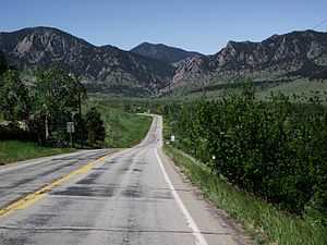
State Highway 170 approaching Eldorado Springs
State Highway 170 (SH 170) is a state highway in Colorado that connects Eldorado Springs and Superior.
Route description
The road begins at the edge of Eldorado Canyon State Park at El Dorado Springs. SH 170 then heads eastward, meeting County Road 67 before passing through a rural grassy area. The route then meets State Highway 93, where it becomes Marshall Drive, just north of Marshall Lake. The road then finds its eastern terminus at U.S. Highway 36, the Denver-Boulder Turnpike, passing through the city of Superior.[2]
Major intersections
The entire route is in Boulder County.
| Location | mi | km | Destinations | Notes | |
|---|---|---|---|---|---|
| Eldorado Springs | 0.000 | 0.000 | Eldorado Canyon State Park | ||
| 2.735 | 4.402 | ||||
| Superior | 6.969 | 11.216 | |||
| 1.000 mi = 1.609 km; 1.000 km = 0.621 mi | |||||