Colonel Light Gardens, South Australia
| Colonel Light Gardens Adelaide, South Australia | |||||||||||||
|---|---|---|---|---|---|---|---|---|---|---|---|---|---|
|
Lincoln Avenue | |||||||||||||
| Population | 3,237 (2006 census)[1] | ||||||||||||
| Postcode(s) | 5041 | ||||||||||||
| LGA(s) | City of Mitcham | ||||||||||||
| State electorate(s) | Waite | ||||||||||||
| Federal Division(s) | Boothby | ||||||||||||
| |||||||||||||
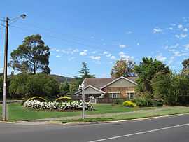
Colonel Light Gardens is a suburb featuring wide, tree-lined streets, well-maintained homes, rounded street corners, and lots of manicured, well maintained open space, located within the City of Mitcham in the greater City of Adelaide, capital of South Australia. The area is 1.58 km².
It contains Colonel Light Gardens Primary School, the Colonel Light Gardens RSL, a number of sporting clubs using the name Reade Park, and a multitude of historical parks and gardens. It also contains many paved and unpaved laneways, alleyways and bike tracks, most of which do not appear on maps.
Naming
Named after the first Surveyor-General of Adelaide, Colonel William Light.[2]
For many years residents in the northern section of the suburb adopted Reade Park as their address to distinguish themselves from the Thousand Homes Scheme area.
The school is named after William Light and is heritage listed. There are about 297 students at the school and each building is named after a historic South Australian figure. The buildings are Reade, Duncan, Mortlock and Holden. The school experienced a severe fire in 2011 but has rebuilt since. The focus on Italian language and culture is popular with local families.
The northern boundary of the suburb is Grange Road.
History
The part of the suburb east of Goodwood Road was used as an army training camp during World War I, and prior to this the area was known as Grange Farm.
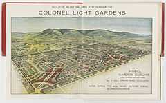
An area of 1.2 km² was purchased in June 1915 by the Vaughan Labor government from the estate of William Tennant Mortlock. The Government decided to establish it as a 'model garden suburb' following New Zealand town planner Charles Reade's 1914 Australian Town Planning Tour.
The Post Office on Goodwood Road originally opened as Light's Gardens, was renamed Colonel Light Gardens on 1 January 1929 and Daw Park in 1967.[3]
Until the 1970s the suburb was administered under the Garden Suburb Act and controlled by a South Australian government appointed Garden Suburb Commissioner, who carried out the functions of local government until it was eventually absorbed by the Mitcham Council.
The suburb contains many well preserved Bungalow homes, and in October 1999 was placed on the Register of The National Estate. In 2000, the suburb was declared a State Heritage Area. For the heritage significance of Colonel Light Gardens see the State Heritage Branch web page on Colonel Light Gardens.
Many Adelaide residents are confused by the unusual layout of Colonel Light Gardens, and its maze of laneways and curved streets. Part of the suburb is said to significantly resemble a rising sun (the symbol of the Australian military) or a Union Flag when viewed from the air. However, it was not designed this way. The Colonel Light Gardens Historical Society website suburb myths section explains in more detail.
Transport
The suburb is served by Adelaide Metro buses along Goodwood Road, East Parkway, Grange Road and Springbank Road.
The closest railway stations, Mitcham and Torrens Park on the Belair railway line, are situated some distance to the east on Belair Road. (Clapham station was closed in 1995).
Politics
Local government: City of Mitcham, Gault Ward
State government: Electoral district of Waite in the South Australian House of Assembly
Federal government: Seat of Boothby in the Australian House of Representatives
See also
References
- ↑ Australian Bureau of Statistics (25 October 2007). "Colonel Light Gardens (State Suburb)". 2006 Census QuickStats. Retrieved 16 July 2008.
- ↑ Naming of Colonel Light Gardens
- ↑ Premier Postal History. "Post Office List". Premier Postal Auctions. Retrieved 26 May 2011.
External links
- Entry in Australian Heritage database
- Mitcham Council's information page
- Colonel Light Gardens Historical Society
- "Entry AHD19429". Australian Heritage Database. Department of Sustainability, Environment, Water, Population and Communities.
- South Australian State Heritage Area-Colonel Light Gardens
Coordinates: 34°58′55″S 138°35′31″E / 34.982°S 138.592°E