Colle di Tora
| Colle di Tora | |
|---|---|
| Comune | |
| Comune di Colle di Tora | |
 Colle di Tora Location of Colle di Tora in Italy | |
| Coordinates: 42°13′N 12°57′E / 42.217°N 12.950°ECoordinates: 42°13′N 12°57′E / 42.217°N 12.950°E | |
| Country | Italy |
| Region | Latium |
| Province | Province of Rieti (RI) |
| Area | |
| • Total | 14.2 km2 (5.5 sq mi) |
| Elevation | 542 m (1,778 ft) |
| Population (Dec. 2004) | |
| • Total | 373 |
| • Density | 26/km2 (68/sq mi) |
| Demonym | Collepiccolesi |
| Time zone | CET (UTC+1) |
| • Summer (DST) | CEST (UTC+2) |
| Postal code | 02020 |
| Dialing code | 0765 |
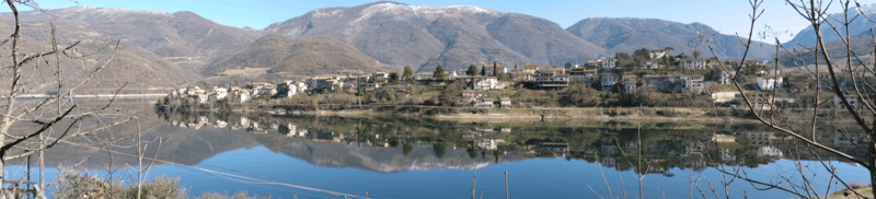
A landscape of Colle di Tora on a windless day
Colle di Tora is a comune (municipality) in the Province of Rieti in the Italian region Latium, located about 50 kilometres (31 mi) northeast of Rome and about 20 kilometres (12 mi) southeast of Rieti. As of 31 December 2004, it had a population of 373 and an area of 14.2 square kilometres (5.5 sq mi).[1]
Colle di Tora borders the following municipalities: Castel di Tora, Poggio Moiano, Pozzaglia Sabina, Rocca Sinibalda.
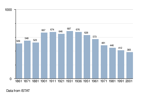
Demographic evolution