Coll de Nargó
Coll de Nargó is a municipality in the comarca of the Alt Urgell in
Catalonia, a region of Spain. It is situated in the Segre valley by the Oliana reservoir. The municipality
is served by the C-14 road between Ponts and La Seu d'Urgell, the L-511 road to Isona and the L-401 road to
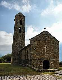
Sant Llorenç de Morunys. The Romanesque church of Sant Climent dates from the eleventh century,
and has a rectangular pre-Romanesque bell-tower.
Demography
| 1900 |
1930 |
1950 |
1970 |
1986 |
2005 |
| 1389 |
1565 |
1511 |
847 |
684 |
600 |
Subdivisions
The municipality of Coll de Nargó includes five outlying villages. Populations are given as of 2001, when the population of the village of Coll de Nargó was 463:
- Gavarra (26), bordering the comarca of the Noguera
- Les Masies de Nargó (30)
- Montanissell (28), at the foot of the Sant Joan range
- Sallent (38), on the south side of the Sant Joan range, linked with Montanissell by a forest track
- Valldarques (15)
References
- Panareda Clopés, Josep Maria; Rios Calvet, Jaume; Rabella Vives, Josep Maria (1989). Guia de Catalunya, Barcelona:Caixa de Catalunya. ISBN 84-87135-01-3 (Spanish). ISBN 84-87135-02-1 (Catalan).