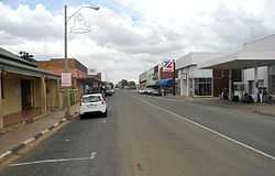
Coligny, North West
| Coligny | |
|---|---|
|
Street in Coligny | |
 Coligny
| |
| Coordinates: 26°20′S 26°19′E / 26.333°S 26.317°ECoordinates: 26°20′S 26°19′E / 26.333°S 26.317°E | |
| Country | South Africa |
| Province | North West |
| District | Ngaka Modiri Molema |
| Municipality | Ditsobotla |
| Area[1] | |
| • Total | 4.36 km2 (1.68 sq mi) |
| Population (2011)[1] | |
| • Total | 2,271 |
| • Density | 520/km2 (1,300/sq mi) |
| Racial makeup (2011)[1] | |
| • Black African | 43.2% |
| • Coloured | 3.4% |
| • Indian/Asian | 1.9% |
| • White | 49.8% |
| • Other | 1.7% |
| First languages (2011)[1] | |
| • Afrikaans | 50.6% |
| • Tswana | 34.6% |
| • English | 6.6% |
| • Xhosa | 1.4% |
| • Other | 6.8% |
| Postal code (street) | 2725 |
| PO box | 2725 |
| Area code | 018 |
Coligny is a maize farming town situated next to the railway line between Lichtenburg and Johannesburg in North West Province of South Africa.
Town some 27 km south-east of Lichtenburg. Originally named as Treurfontein ("spring of sadness"), it was renamed Coligny when it became a town on 23 July 1923, after Gaspard de Coligny, a Huguenot leader who died in the Massacre of St Bartholomew in 1572.[2] Scene of sporadic diamond mining activities.
References
- ↑ 1.0 1.1 1.2 1.3 "Main Place Coligny". Census 2011.
- ↑ Raper, Peter E. (1987). Dictionary of Southern African Place Names. Internet Archive. p. 122. Retrieved 28 August 2013.
| |||||||||||||||||||||||||||||

.svg.png)