Colbert County, Alabama
| Colbert County, Alabama | |
|---|---|
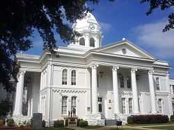 Colbert County Courthouse in Tuscumbia | |
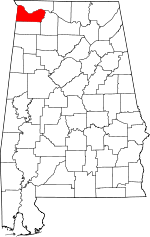 Location in the state of Alabama | |
 Alabama's location in the U.S. | |
| Founded | February 6, 1867 |
| Named for | George and Levi Colbert |
| Seat | Tuscumbia |
| Largest city | Muscle Shoals |
| Area | |
| • Total | 622 sq mi (1,611 km2) |
| • Land | 593 sq mi (1,536 km2) |
| • Water | 30 sq mi (78 km2), 4.7% |
| Population | |
| • (2010) | 54,428 |
| • Density | 91/sq mi (35/km²) |
| Congressional district | 4th |
| Time zone | Central: UTC-6/-5 |
| Website |
www |
Colbert County (/kɒlˈbɜrt/ kol-BURT, with stress on the final syllable)[1] is a county of the U.S. state of Alabama. As of the 2010 census the county's population was 54,428.[2] The county seat is Tuscumbia.[3] Its name is in honor of brothers George and Levi Colbert, Chickasaw Indian chiefs.[4]
Colbert County is part of the Florence-Muscle Shoals, AL Metropolitan Statistical Area, also known as "The Shoals".
History
Colbert County was originally established on February 6, 1867 after it split from Franklin County over political issues after the American Civil War. It was abolished eight months later on November 29, 1867[5] by an Alabama constitutional convention and then reestablished on February 24, 1870.[4] It is also the location of Ivy Green, the birthplace of noted author Helen Keller.[4] Colbert County is also home of the towns Sheffield and Muscle Shoals where many popular musicians such as Aretha Franklin and the Rolling Stones recorded music. Colbert County is the home of the Key Underwood Coon Dog Memorial Graveyard established in 1937.[6]
Geography
According to the U.S. Census Bureau, the county has a total area of 622 square miles (1,610 km2), of which 593 square miles (1,540 km2) is land and 30 square miles (78 km2) (4.7%) is water.[7]
National protected area
- Natchez Trace Parkway (part)
River
Adjacent Counties
- Lauderdale County, Alabama - north
- Lawrence County, Alabama - southeast
- Franklin County, Alabama - south
- Tishomingo County, Mississippi - west
Transportation
Major Highways
 U.S. Highway 43
 U.S. Highway 72
 State Route 20
 State Route 157
 State Route 247
- Natchez Trace Parkway
Rail
- Norfolk Southern Railway - freight lines going South, East, and West.[8]
Demographics
| Historical population | |||
|---|---|---|---|
| Census | Pop. | %± | |
| 1870 | 12,537 | — | |
| 1880 | 16,153 | 28.8% | |
| 1890 | 20,189 | 25.0% | |
| 1900 | 22,341 | 10.7% | |
| 1910 | 24,802 | 11.0% | |
| 1920 | 31,997 | 29.0% | |
| 1930 | 29,860 | −6.7% | |
| 1940 | 34,093 | 14.2% | |
| 1950 | 39,561 | 16.0% | |
| 1960 | 46,506 | 17.6% | |
| 1970 | 49,632 | 6.7% | |
| 1980 | 54,519 | 9.8% | |
| 1990 | 51,666 | −5.2% | |
| 2000 | 54,984 | 6.4% | |
| 2010 | 54,428 | −1.0% | |
| Est. 2013 | 54,520 | 0.2% | |
| U.S. Decennial Census[9] 1790-1960[10] 1900-1990[11] 1990-2000[12] 2010-2013[2] | |||
As of the census[13] of 2000, there were 54,984 people, 22,461 households, and 16,037 families residing in the county. The population density was 92 people per square mile (36/km2). There were 24,980 housing units at an average density of 42 per square mile (16/km2). The racial makeup of the county was 78.52% White or European American (non-Hispanic), 16.62% Black or African American, 0.37% Native American, 0.24% Asian, 0.02% Pacific Islander, 0.34% from other races, and 0.89% from two or more races. 1.12% of the population were Hispanic or Latino of any race.
2010
According to the 2010 U.S. Census Bureau:
- 80.4% White (non-Hispanic)
- 14.0% Black
- 0.4% Native American
- 0.7% Asian
- 0.0% Native Hawaiian or Pacific Islander
- 0.91% Two or more races
- 2.0% Hispanic or Latino (of any race)
There were 22,461 households out of which 30.50% had children under the age of 18 living with them, 56.00% were married couples living together, 12.10% had a female householder with no husband present, and 28.60% were non-families. 26.10% of all households were made up of individuals and 11.50% had someone living alone who was 65 years of age or older. The average household size was 2.42 and the average family size was 2.92.
In the county the population was spread out with 23.80% under the age of 18, 8.10% from 18 to 24, 27.80% from 25 to 44, 24.90% from 45 to 64, and 15.40% who were 65 years of age or older. The median age was 39 years. For every 100 females there were 91.80 males. For every 100 females age 18 and over, there were 88.10 males.
The median income for a household in the county was $31,954, and the median income for a family was $39,294. Males had a median income of $32,112 versus $20,107 for females. The per capita income for the county was $17,533. About 11.10% of families and 14.00% of the population were below the poverty line, including 18.40% of those under age 18 and 11.90% of those age 65 or over.
Communities
Cities
Towns
Unincorporated communities
In popular culture
- Colbert County was featured in a three-part comedy feature on Comedy Central's The Colbert Report from November 28–30, 2006.
See also
- National Register of Historic Places listings in Colbert County, Alabama
- Properties on the Alabama Register of Landmarks and Heritage in Colbert County, Alabama
References
- ↑ Place Names in Alabama - Virginia O. Foscue - Google Books. Books.google.com. Retrieved 2014-08-04.
- ↑ 2.0 2.1 "State & County QuickFacts". United States Census Bureau. Retrieved May 16, 2014.
- ↑ "Find a County". National Association of Counties. Retrieved 2011-06-07.
- ↑ 4.0 4.1 4.2 "Colbert County Website". Retrieved 2007-05-16.
- ↑ "Alabama Counties: Colbert County". Alabama Department of Archives and History. Montgomery, AL: Alabama Department of Archives and History. 2009-11-20. Retrieved 2012-04-30.
- ↑ Kazek, Kelly (August 19, 2014). "Legendary Coon Dog Cemetery to once again host Labor Day celebration with live music, crafts, barbecue". The Huntsville Times (Huntsville, AL). Retrieved August 20, 2014.
- ↑ "US Gazetteer files: 2010, 2000, and 1990". United States Census Bureau. 2011-02-12. Retrieved 2011-04-23.
- ↑ Alabama Railway Map. 2008. Alabama Department of Transportation. Accessed 2012-03-15.
- ↑ "U.S. Decennial Census". United States Census Bureau. Retrieved May 16, 2014.
- ↑ "Historical Census Browser". University of Virginia Library. Retrieved May 16, 2014.
- ↑ "Population of Counties by Decennial Census: 1900 to 1990". United States Census Bureau. Retrieved May 16, 2014.
- ↑ "Census 2000 PHC-T-4. Ranking Tables for Counties: 1990 and 2000" (PDF). United States Census Bureau. Retrieved May 16, 2014.
- ↑ "American FactFinder". United States Census Bureau. Retrieved 2008-01-31.
External links
 |
Lauderdale County | | ||
| Tishomingo County, Mississippi | |
|||
| ||||
| | ||||
| Franklin County | Lawrence County |
| |||||||||||||||||||||
| ||||||||||||||||||||||||||||||||||
Coordinates: 34°40′36″N 87°49′02″W / 34.67667°N 87.81722°W