Cockpit Country
| Cockpit Country | |
|---|---|
| Geographical Region | |
 | |
 Cockpit Country | |
| Coordinates: 18°17′43″N 77°41′43″W / 18.295209°N 77.695313°W | |
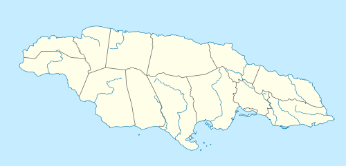
| Country | Jamaica |
| Parish | Trelawny |
| Named for | Topology reminiscent of the shape of cock fighting dens. |
| Time zone | EST (UTC-5) |
Cockpit Country is an area in Jamaica, specifically Trelawny, which provided a natural defensive area used by Maroons to establish communities outside the control of Spanish or British colonialists.
Cockpit Country is pockmarked with steep-sided hollows, as much as 120 metres (390 ft) deep in places, which are separated by conical hills and ridges.
On the north, the main defining feature is the fault-based "Escarpment", a long ridge that extends from Flagstaff in the west, through Windsor in the centre, to Campbells and the start of the Barbecue Bottom Road (B10). The Barbecue Bottom Road, which runs north-south, high along the side of a deep, fault-based valley in the east, is the only drivable route across the Cockpit Country. However, there are two old, historical trails that cross further west, the Troy Trail, and the Quick Step Trail, both of which are seldom used as of 2006 and difficult to find. (Note: The Barbecue Bottom/Burnt Hill road is blocked toward the south end by large fallen rocks as of 11 December 2011.)
In the southwest, near Quick Step, is the district known as the "Land of Look Behind," so named because Spanish horsemen venturing into this region of hostile runaway slaves were said to have ridden two to a mount, one rider facing to the rear to keep a precautionary watch.
Where the ridges between sinkholes in the plateau area have dissolved, flat-bottomed basins or valleys have been formed that are filled with terra rosa soils, some of the most productive on the island. The largest basin is the Vale of Clarendon, 80 kilometres (50 mi) long and 32 kilometres (20 mi) wide. Queen of Spains Valley, Nassau Valley, and Cave Valley were formed by the same process.
Environment
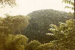
The Cockpit Country is Jamaica's largest remaining contiguous rainforest. In 1979 an unpublished paper proposed the possibility of a National Park[1] In 1994 the geographer Alan Eyre[2] proposed that the Cockpit Country be zoned a World Heritage Site. A petition for protection of the area was submitted to Prime Minister Bruce Golding in 2006.
As of April, 2013, public consultations have begun on the definition of the boundary proposed in a recently released study by Mitchell, Miller, Ganapathy, and Spence of the University of the West Indies (UWI).
Eleutherodactylus sisyphodemus, a small critically endangered frog species, is only known from the Cockpit Country.[3][4]
In popular culture
- 1957: In the Horatio Hornblower novel Hornblower in the West Indies, by C. S. Forester, the protagonist is kidnapped by pirates and taken to a hideout in Cockpit Country
References
- ↑ Cotterell "The proposed development of the Cockpit Country." Unpublished. NRCD, Kingston, Jamaica. 1979.
- ↑ Eyre Slow death of a tropical rainforest: The Cockpit Country of Jamaica, West Indies 1994
- ↑ Hedges, B., Koenig, S. & Wilson, B. (2004). "Eleutherodactylus sisyphodemus". IUCN Red List of Threatened Species. Version 2014.3. International Union for Conservation of Nature. Retrieved 18 April 2015.
- ↑ Frost, Darrel R. (2015). "Eleutherodactylus sisyphodemus Crombie, 1977". Amphibian Species of the World: an Online Reference. Version 6.0. American Museum of Natural History. Retrieved 18 April 2015.
See also
External links
| Wikimedia Commons has media related to Cockpit Country. |
Coordinates: 18°17′43″N 77°41′43″W / 18.2952094°N 77.6953125°W
| ||||||||||||||||||||||||||||||||||||||||||||||||||||||||||||||||||||||||||||||||||||||||||