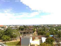
Coari
| Coari | |||
|---|---|---|---|
| Municipality | |||
 | |||
| |||
| Nickname(s): Cidade do Gás | |||
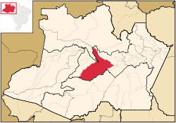 Coari municipality (red) in Amazonas state | |||
| Coordinates: 04°05′06″S 63°08′27″W / 4.08500°S 63.14083°WCoordinates: 04°05′06″S 63°08′27″W / 4.08500°S 63.14083°W | |||
| Government | |||
| • Mayor | Manoel Adail Amaral Pinheiro (PRP) | ||
| Area | |||
| • Municipality | 57,921.646 km2 (22,363.673 sq mi) | ||
| Elevation | 40 m (120 ft) | ||
| Population (2014) | |||
| • Density | 1.334/km2 (3.46/sq mi) | ||
| • Metro | 82,209 | ||
| Time zone | AST(UTC-4 (UTC-4) | ||
| • Summer (DST) | DST no longer used (UTC-4) | ||
| ZIP code | 69460-000 | ||
| Website | http://www.coari.am.gov.br/ | ||


Coari (Choary) is a Brazilian municipality in the Amazon region. It is also one of the largest cities of the Amazonas state. It is the seat of the Roman Catholic Diocese of Coari. The area has reserves of oil and natural gas.
Coari is served by Coari Airport located 6 km from downtown Coari. Porto Urucu Airport located in the district of Porto Urucu 470 km away serves the population residing and working for Petrobras.