Cloverdale Municipal Airport
| Cloverdale Municipal Airport | |||||||||||
|---|---|---|---|---|---|---|---|---|---|---|---|
 | |||||||||||
| IATA: none – ICAO: none – FAA LID: O60 | |||||||||||
| Summary | |||||||||||
| Airport type | City of Cloverdale | ||||||||||
| Operator | Cloverdale, California | ||||||||||
| Location | 272 | ||||||||||
| Elevation AMSL | 82.9 ft / 25 m | ||||||||||
| Coordinates | 38°46′34″N 122°59′33″W / 38.77611°N 122.99250°WCoordinates: 38°46′34″N 122°59′33″W / 38.77611°N 122.99250°W | ||||||||||
| Runways | |||||||||||
| |||||||||||
Cloverdale Municipal Airport (FAA LID: O60) is a public airport located three miles (4.8 km) southeast of Cloverdale, serving Sonoma County, California, USA. The airport is mostly used for general aviation.[1] There are additional activities on the airport: Skydiving, ultralight and experimental activities; it is home to Quality Sport Planes, the western representative for Zenith Aircraft Company since 2005.
Facilities
Cloverdale Municipal Airport covers 58 acres (230,000 m2) and has one runway:
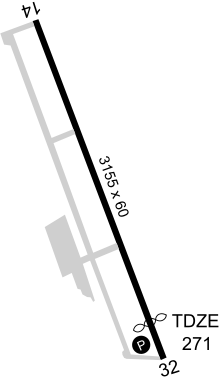
- Runway 14/32: 3,155 x 60 ft (962 x 18 m), Surface: Asphalt
References
- ↑ "Cloverdale Municipal Airport". Geographic Names Information System. United States Geological Survey. Retrieved 2009-05-04.
External links
- Quality Sport Planes, LLC
- NorCal Skydiving activities on airport
- FAA Airport Master Record for O60 (Form 5010 PDF)
- Resources for this airport:
- FAA airport information for O60
- AirNav airport information for O60
- FlightAware airport information and live flight tracker
- SkyVector aeronautical chart for O60
| ||||||||||||||||||||||