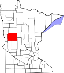
Clitherall, Minnesota
| Clitherall, Minnesota | |
|---|---|
| City | |
 Location of Clitherall, Minnesota | |
| Coordinates: 46°16′31″N 95°37′48″W / 46.27528°N 95.63000°W | |
| Country | United States |
| State | Minnesota |
| County | Otter Tail |
| Area[1] | |
| • Total | 0.20 sq mi (0.52 km2) |
| • Land | 0.20 sq mi (0.52 km2) |
| • Water | 0 sq mi (0 km2) |
| Elevation | 1,348 ft (411 m) |
| Population (2010)[2] | |
| • Total | 112 |
| • Estimate (2012[3]) | 112 |
| • Density | 560.0/sq mi (216.2/km2) |
| Time zone | Central (CST) (UTC-6) |
| • Summer (DST) | CDT (UTC-5) |
| ZIP code | 56524 |
| Area code(s) | 218 |
| FIPS code | 27-12088[4] |
| GNIS feature ID | 0641341[5] |
Clitherall is a city in Otter Tail County, Minnesota, United States. The population was 112 at the 2010 census.[6]
Geography
According to the United States Census Bureau, the city has a total area of 0.20 square miles (0.52 km2), all of it land.[1]
Minnesota State Highway 210 serves as a main route in the community.
History
Clitherall was founded in 1864 by members of the Church of Jesus Christ (Cutlerite), a small Latter Day Saint faction started in 1853 by Alpheus Cutler, a former associate of Joseph Smith, Jr., founder of the original Latter Day Saint church in 1830. This group relocated to the area from Manti, Iowa following Cutler's death in 1864, and included Cutler's widow, Lois. Although the area had been ravaged by the Sioux uprising of 1862 and wasn't considered safe for settlement, the Cutlerites got along well with the local Native Americans and the town thrived for several years.
Ultimately the majority of Cutlerites chose to relocate to Independence, Missouri during the 1920s, where their church headquarters (and sole branch) remains today. The Cutlerite remnant in Minnesota slowly dwindled over the following years, being only briefly revived by an attempt by Clitherall resident Clyde Fletcher to found his own Cutlerite faction from 1953-69. This faction was headquartered in the old Cutlerite meetinghouse in town, but ceased to exist upon Fletcher's death, when his few remaining adherents chose to reunite with the mainline Independence, Missouri congregation. The last known Cutlerite resident of Clitherall died during the 1990s, though the church still owns property in the area including their old meetinghouse, which once served as the headquarters of Fletcher's breakaway denomination.
Demographics
2010 census
As of the census[2] of 2010, there were 112 people, 52 households, and 30 families residing in the city. The population density was 560.0 inhabitants per square mile (216.2/km2). There were 64 housing units at an average density of 320.0 per square mile (123.6/km2). The racial makeup of the city was 98.2% White, 0.9% African American, and 0.9% from two or more races.
There were 52 households of which 25.0% had children under the age of 18 living with them, 40.4% were married couples living together, 9.6% had a female householder with no husband present, 7.7% had a male householder with no wife present, and 42.3% were non-families. 36.5% of all households were made up of individuals and 15.4% had someone living alone who was 65 years of age or older. The average household size was 2.04 and the average family size was 2.60.
The median age in the city was 50.5 years. 20.5% of residents were under the age of 18; 4.6% were between the ages of 18 and 24; 19.8% were from 25 to 44; 28.6% were from 45 to 64; and 26.8% were 65 years of age or older. The gender makeup of the city was 50.0% male and 50.0% female.
2000 census
As of the census[4] of 2000, there were 118 people, 51 households, and 32 families residing in the city. The population density was 586.2 people per square mile (227.8/km²). There were 62 housing units at an average density of 308.0 per square mile (119.7/km²). The racial makeup of the city was 94.92% White, 4.24% Native American, and 0.85% from two or more races.
There were 51 households out of which 23.5% had children under the age of 18 living with them, 58.8% were married couples living together, 2.0% had a female householder with no husband present, and 35.3% were non-families. 29.4% of all households were made up of individuals and 15.7% had someone living alone who was 65 years of age or older. The average household size was 2.31 and the average family size was 2.91.
In the city the population was spread out with 23.7% under the age of 18, 8.5% from 18 to 24, 24.6% from 25 to 44, 22.0% from 45 to 64, and 21.2% who were 65 years of age or older. The median age was 38 years. For every 100 females there were 107.0 males. For every 100 females age 18 and over, there were 104.5 males.
The median income for a household in the city was $26,667, and the median income for a family was $30,625. Males had a median income of $25,625 versus $17,813 for females. The per capita income for the city was $15,113. There were 6.5% of families and 10.0% of the population living below the poverty line, including no under eighteens and 9.1% of those over 64.
References
- ↑ 1.0 1.1 "US Gazetteer files 2010". United States Census Bureau. Retrieved 2012-11-13.
- ↑ 2.0 2.1 "American FactFinder". United States Census Bureau. Retrieved 2012-11-13.
- ↑ "Population Estimates". United States Census Bureau. Retrieved 2013-05-28.
- ↑ 4.0 4.1 "American FactFinder". United States Census Bureau. Retrieved 2008-01-31.
- ↑ "US Board on Geographic Names". United States Geological Survey. 2007-10-25. Retrieved 2008-01-31.
- ↑ "2010 Census Redistricting Data (Public Law 94-171) Summary File". American FactFinder. U.S. Census Bureau, 2010 Census. Retrieved 23 April 2011.
| |||||||||||||||||||||||||||||
Coordinates: 46°16′30″N 95°37′52″W / 46.27500°N 95.63111°W
