Clinton Township, Vermillion County, Indiana
| Clinton Township | |
|---|---|
| Township | |
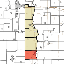 Location in Vermillion County | |
| Coordinates: 39°38′56″N 87°27′26″W / 39.64889°N 87.45722°WCoordinates: 39°38′56″N 87°27′26″W / 39.64889°N 87.45722°W | |
| Country | United States |
| State | Indiana |
| County | Vermillion |
| Government | |
| • Type | Indiana township |
| Area | |
| • Total | 46.35 sq mi (120.0 km2) |
| • Land | 45.25 sq mi (117.2 km2) |
| • Water | 1.1 sq mi (3 km2) 2.37% |
| Elevation | 551 ft (168 m) |
| Population (2010) | |
| • Total | 9,119 |
| • Density | 201.5/sq mi (77.8/km2) |
| ZIP codes | 47842, 47884 |
| GNIS feature ID | 0453234 |
Clinton Township is one of five townships in Vermillion County, Indiana, United States. As of the 2010 census, its population was 9,119 and it contained 4,281 housing units.[1]
Geography
According to the 2010 census, the township has a total area of 46.35 square miles (120.0 km2), of which 45.25 square miles (117.2 km2) (or 97.63%) is land and 1.1 square miles (2.8 km2) (or 2.37%) is water.[1]
Cities
Unincorporated towns
Extinct towns
- Crompton Hill
- Easytown
- Klondyke
- Needmore
- Rhodes
- Sandytown
- Tighe
Cemeteries
The township contains eight cemeteries: Bono, Gorton, Hall, Jackson, Riverview, Shirley, Spangler and Walnut Grove.
Lakes
- Mc Donald Lake
Landmarks
- Sportland Park
School districts
- South Vermillion Community School Corporation
Political districts
- Indiana's 8th congressional district
- State House District 42
- State Senate District 38
References
- ↑ 1.0 1.1 "Population, Housing Units, Area, and Density: 2010 - County -- County Subdivision and Place -- 2010 Census Summary File 1". United States Census. Retrieved 2013-05-10.
External links

| |||||||||||||||||||||||||||||||||