Claydon, Suffolk

Coordinates: 52°06′26″N 1°06′32″E / 52.10729°N 1.10898°E
Claydon is a small village just north of Ipswich in Suffolk, England. The meaning of the name is 'clay-on-the-hill'.
The village gives its name to the hundred of Bosmere-and-Claydon, one of the 21 districts into which Suffolk was divided for administrative purposes between Saxon and Victorian times.[1]
Geography
The countryside around Claydon is set among low-lying hills and lies next to the River Gipping. It is close to the intersection of the A14 and the B1113. Between the A14 and the B1113 (former A45) is the Ipswich to Ely Line.
Amenities
The village offers two pubs for the traveller and locals, The Crown and The Greyhound. There is also a post office, hairdressers, car dealership and travel agency. It also has a primary school and a high school. The high school on Church Lane is now a specialist Humanities College since September 2004, it also has a sixth form centre alongside with Thurleston. There are regular bus connections to Ipswich, Bramford and Stowmarket from the centre of the village.
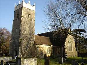
At the top of the hill on Lane can be found the Church of St Peter, which has been partially restored. It is one of the few pre-Norman churches in Suffolk. The interior is attractive with a very fine wooden fan vaulted ceiling.
Nearby villages include Barham, Bramford, Great Blakenham and the hamlet of Akenham.
Notable residents
- Stuart Hill (sailor)
References
- ↑ Walter Skeat (1913). The Place-names of Suffolk.
External links
| Wikimedia Commons has media related to Claydon, Suffolk. |