Clark Township, Marion County, Kansas
| Clark Township Marion County, Kansas | |
|---|---|
| Township | |
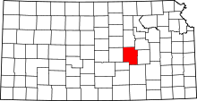
 Location within Marion County | |
 Clark Township Marion County, Kansas Location within the state of Kansas | |
| Coordinates: 38°28′17″N 097°6′4″W / 38.47139°N 97.10111°WCoordinates: 38°28′17″N 097°6′4″W / 38.47139°N 97.10111°W | |
| Country | United States |
| State | Kansas |
| County | Marion |
| Area | |
| • Total | 36 sq mi (90 km2) |
| Dimensions | |
| • Length | 6.0 mi (9.7 km) |
| • Width | 6.0 mi (9.7 km) |
| Elevation | 1,391 ft (424 m) |
| Population (2010)[1] | |
| • Total | 147 |
| • Density | 4.1/sq mi (1.6/km2) |
| Time zone | CST (UTC-06:00) |
| • Summer (DST) | CDT (UTC-05:00) |
| Area code(s) | 620 |
| FIPS code | 20-13500 [2] |
| GNIS feature ID | 477130 [3] |
| Website | County Website |
|
| |
Clark Township is a township in Marion County, Kansas, United States. As of the 2010 census, the township population was 147, including the west side of Pilsen.[1]
Geography
Clark Township covers an area of 36 square miles (93.2 km2).
Cities and towns
The township contains the following settlements:
- Unincorporated community of Pilsen (west of Remington Road). The east part is located in Clear Creek Township.
Cemeteries
The township contains the following cemeteries:
- No cemeteries.
Further reading
References
- ↑ 1.0 1.1 "2010 Total Population - Township of Clark". U.S. Census Bureau. Retrieved June 18, 2013.
- ↑ "American FactFinder". United States Census Bureau. Retrieved 2011-05-14.
- ↑ U.S. Geological Survey Geographic Names Information System: Township of Clark
External links
- Marion County Website
- City-Data.com
- Marion County Maps: Current, Historic, KDOT
 |
Blaine Township | Colfax Township | Lost Springs Township | |
| Durham Park Township | |
Clear Creek Township | ||
| ||||
| | ||||
| Risley Township | Gale Township | Center Township |
| |||||||||||||||||||||||||||||