Claira
| Claira | ||
|---|---|---|
|
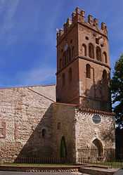
The church of Saint-Vincent, in Claira | ||
| ||
 Claira | ||
|
Location within Languedoc-Roussillon region  Claira | ||
| Coordinates: 42°45′40″N 2°57′22″E / 42.7611°N 2.9561°ECoordinates: 42°45′40″N 2°57′22″E / 42.7611°N 2.9561°E | ||
| Country | France | |
| Region | Languedoc-Roussillon | |
| Department | Pyrénées-Orientales | |
| Arrondissement | Perpignan | |
| Canton | Saint-Laurent-de-la-Salanque | |
| Intercommunality | Salanque-Méditerranée | |
| Government | ||
| • Mayor (2008–2014) | Joseph Puig | |
| Area1 | 19.34 km2 (7.47 sq mi) | |
| Population (2006)2 | 3,422 | |
| • Density | 180/km2 (460/sq mi) | |
| INSEE/Postal code | 66050 / 66530 | |
| Elevation |
5–20 m (16–66 ft) (avg. 10 m or 33 ft) | |
|
1 French Land Register data, which excludes lakes, ponds, glaciers > 1 km² (0.386 sq mi or 247 acres) and river estuaries. 2 Population without double counting: residents of multiple communes (e.g., students and military personnel) only counted once. | ||

Claira (Catalan: Clairà) is a commune in the Pyrénées-Orientales department in southern France.
Geography
Claira is located in the canton of Saint-Laurent-de-la-Salanque and in the arrondissement of Perpignan.
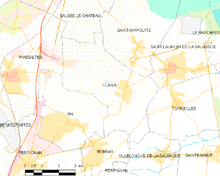
Map of Claira and its surrounding communes
Claira is located 5 km from Perpignan.
See also
References
External links
| Wikimedia Commons has media related to Claira. |