Civil parishes in Cheshire
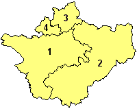
A map of Cheshire, showing the Boroughs : (1) Cheshire West and Chester; (2) Cheshire East; (3) Warrington; and (4) Halton.

A civil parish is a country subdivision, forming the lowest unit of local government in England. There are 332 civil parishes in the ceremonial county of Cheshire, most of the county being parished. At the 2001 census, there were 565,259 people living in the 332 parishes, accounting for 57.5 per cent of the county's population.

History

Parishes arose from Church of England divisions, and were originally purely ecclesiastical divisions. Over time they acquired civil administration powers.[1]

The Highways Act 1555 made parishes responsible for the upkeep of roads. Every adult inhabitant of the parish was obliged to work four days a year on the roads, providing their own tools, carts and horses; the work was overseen by an unpaid local appointee, the Surveyor of Highways.[2]

The poor were looked after by the monasteries, until their dissolution. In 1572, magistrates were given power to 'survey the poor' and impose taxes for their relief. This system was made more formal by the Poor Law Act 1601, which made parishes responsible for administering the Poor Law; overseers were appointed to charge a rate to support the poor of the parish.[3] The 19th century saw an increase in the responsibility of parishes, although the Poor Law powers were transferred to Poor Law Unions.[4] The Public Health Act 1872 grouped parishes into Rural Sanitary Districts, based on the Poor Law Unions; these subsequently formed the basis for Rural Districts.[5]

Parishes were run by vestries, meeting annually to appoint officials, and were generally identical to ecclesiastical parishes,[6] although some townships in large parishes administered the Poor Law themselves; under the Divided Parishes and Poor Law Amendment Act 1882, all extra-parochial areas and townships that levied a separate rate became independent civil parishes.[7]

Civil parishes in their modern sense date from the Local Government Act 1894, which abolished vestries; established elected parish councils in all rural parishes with more than 300 electors; grouped rural parishes into Rural Districts; and aligned parish boundaries with county and borough boundaries.[7] Urban civil parishes continued to exist, and were generally coterminous with the Urban District, Municipal Borough or County Borough in which they were situated; many large towns contained a number of parishes, and these were usually merged into one. Parish councils were not formed in urban areas, and the only function of the parish was to elect guardians to Poor Law Unions; with the abolition of the Poor Law system in 1930 the parishes had only a nominal existence.[8]

The Local Government Act 1972 retained civil parishes in rural areas, and many former Urban Districts and Municipal Boroughs that were being abolished, were replaced by new successor parishes; urban areas that were considered too large to be single parishes became unparished areas.[9]

The current position

Recent governments have encouraged the formation of town and parish councils in unparished areas, and the Local Government and Rating Act 1997 gave local residents the right to demand the creation of a new civil parish.[10]

A parish council can become a town council unilaterally, simply by resolution;[9] and a civil parish can also gain city status, but only if that is granted by the Crown.[9] The chairman of a town or city council is called a mayor.[9] The Local Government and Public Involvement in Health Act 2007 introduced alternative names: a parish council can now choose to be called a community; village; or neighbourhood council.[11]

List of civil parishes and unparished areas

Image Name Status Population District Former local authority [12] Refs
Acton Civil parish 311 Cheshire East Nantwich
Rural District
[13]
[14]
Adlington Civil parish 1,081 Cheshire East Macclesfield
Rural District
[15]
[16]
Agden Civil parish 146 Cheshire East Bucklow
Rural District
[17]
[16]
Alderley Edge Civil parish 4,409 Cheshire East Alderley Edge
Urban District
[18]
[16]
Alpraham Civil parish 373 Cheshire East Nantwich
Rural District
[13]
[14]
Alsager Town 12,578 Cheshire East Alsager
Urban District
[19]
[20]
Arclid Civil parish 199 Cheshire East Congleton
Rural District
[21]
[20]
Ashley Civil parish 261 Cheshire East Bucklow
Rural District
[17]
[16]
Aston by Budworth Civil parish 281 Cheshire East Bucklow
Rural District
[17]
[16]
Aston juxta Mondrum Civil parish 133 Cheshire East Nantwich
Rural District
[13]
[14]
Audlem Civil parish 1,790 Cheshire East Nantwich
Rural District
[13]
[14]
Austerson Civil parish 145 Cheshire East Nantwich
Rural District
[13]
[14]
Baddiley Civil parish 226 Cheshire East Nantwich
Rural District
[13]
[14]
Baddington Civil parish 98 Cheshire East Nantwich
Rural District
[13]
[14]
Barthomley Civil parish 202 Cheshire East Nantwich
Rural District
[13]
[14]
Basford Civil parish 266 Cheshire East Nantwich
Rural District
[13]
[14]
Batherton Civil parish 36 Cheshire East Nantwich
Rural District
[13]
[14]
Betchton Civil parish 620 Cheshire East Congleton
Rural District
[21]
[20]
Bexton Civil parish 9 Cheshire East Bucklow
Rural District
[17]
[16]
Bickerton Civil parish 234 Cheshire East Nantwich
Rural District
[13]
[14]
Blakenhall Civil parish 125 Cheshire East Nantwich
Rural District
[13]
[14]
Bollington Town 7,095 Cheshire East Bollington
Urban District
[22]
[16]
Bosley Civil parish 406 Cheshire East Macclesfield
Rural District
[15]
[16]
Bradwall Civil parish 166 Cheshire East Congleton
Rural District
[21]
[20]
Brereton Civil parish 1,012 Cheshire East Congleton
Rural District
[21]
[20]
Bridgemere Civil parish 133 Cheshire East Nantwich
Rural District
[13]
[14]
Brindley Civil parish 134 Cheshire East Nantwich
Rural District
[13]
[14]
Broomhall Civil parish 206 Cheshire East Nantwich
Rural District
[13]
[14]
Buerton Civil parish 492 Cheshire East Nantwich
Rural District
[13]
[14]
Bulkeley Civil parish 240 Cheshire East Nantwich
Rural District
[13]
[14]
Bunbury Civil parish 1,308 Cheshire East Nantwich
Rural District
[13]
[14]
Burland Civil parish 582 Cheshire East Nantwich
Rural District
[13]
[14]
Calveley Civil parish 269 Cheshire East Nantwich
Rural District
[13]
[14]
Checkley cum Wrinehill Civil parish 104 Cheshire East Nantwich
Rural District
[13]
[14]
Chelford Civil parish 1,254 Cheshire East Macclesfield
Rural District
[15]
[16]
Cholmondeley Civil parish 136 Cheshire East Nantwich
Rural District
[13]
[14]
Cholmondeston Civil parish 153 Cheshire East Nantwich
Rural District
[13]
[14]
Chorley Civil parish 100 Cheshire East Nantwich
Rural District
[13]
[14]
Chorley Civil parish 399 Cheshire East Macclesfield
Rural District
[15]
[16]
Chorlton Civil parish 113 Cheshire East Nantwich
Rural District
[13]
[14]
Church Lawton Civil parish 2,201 Cheshire East Congleton
Rural District
[21]
[20]
Church Minshull Civil parish 431 Cheshire East Nantwich
Rural District
[13]
[14]
Congleton Town 25,750 Cheshire East Congleton
Municipal Borough
[23]
[20]
Coole Pilate Civil parish 60 Cheshire East Nantwich
Rural District
[13]
[14]
Cranage Civil parish 1,130 Cheshire East Congleton
Rural District
[21]
[20]
Crewe Town 48,592 Cheshire East Crewe
Municipal Borough
[24]
[25]
[26]
Crewe Green Civil parish 140 Cheshire East Nantwich
Rural District
[13]
[14]
Disley Civil parish 4,301 Cheshire East Disley
Rural District
[27]
[16]
Dodcott cum Wilkesley Civil parish 380 Cheshire East Nantwich
Rural District
[13]
[14]
Doddington Civil parish 44 Cheshire East Nantwich
Rural District
[13]
[14]
Eaton Civil parish 289 Cheshire East Macclesfield
Rural District
[15]
[16]
Edleston Civil parish 53 Cheshire East Nantwich
Rural District
[13]
[14]
Egerton Civil parish 81 Cheshire East Nantwich
Rural District
[13]
[14]
Faddiley Civil parish 163 Cheshire East Nantwich
Rural District
[13]
[14]
Gawsworth Civil parish 1,673 Cheshire East Macclesfield
Rural District
[15]
[16]
Goostrey Civil parish 2,201 Cheshire East Congleton
Rural District
[21]
[20]
Great Warford Civil parish 615 Cheshire East Macclesfield
Rural District
[15]
[16]
Hankelow Civil parish 272 Cheshire East Nantwich
Rural District
[13]
[14]
Haslington Civil parish 6,781 Cheshire East Nantwich
Rural District
[13]
[14]
Hassall Civil parish 281 Cheshire East Congleton
Rural District
[21]
[20]
Hatherton Civil parish 344 Cheshire East Nantwich
Rural District
[13]
[14]
Haughton Civil parish 223 Cheshire East Nantwich
Rural District
[13]
[14]
Henbury Civil parish 594 Cheshire East Macclesfield
Rural District
[15]
[16]
Henhull Civil parish 71 Cheshire East Nantwich
Rural District
[13]
[14]
High Legh Civil parish 1,632 Cheshire East Bucklow
Rural District
[17]
[16]
Higher Hurdsfield Civil parish 688 Cheshire East Macclesfield
Rural District
[15]
[16]
Holmes Chapel Civil parish 5,669 Cheshire East Congleton
Rural District
[21]
[20]
Hough Civil parish 783 Cheshire East Nantwich
Rural District
[13]
[14]
Hulme Walfield Civil parish 140 Cheshire East Congleton
Rural District
[21]
[20]
Hunsterson Civil parish 156 Cheshire East Nantwich
Rural District
[13]
[14]
Hurleston Civil parish 64 Cheshire East Nantwich
Rural District
[13]
[14]
Kettleshulme Civil parish 315 Cheshire East Macclesfield
Rural District
[15]
[16]
Knutsford Town 12,656 Cheshire East Knutsford
Urban District
[28]
[16]
Lea Civil parish 25 Cheshire East Nantwich
Rural District
[13]
[14]
Leighton Civil parish 4,863 Cheshire East Nantwich
Rural District
[13]
[14]
Little Bollington Civil parish 162 Cheshire East Bucklow
Rural District
[17]
[16]
Little Warford Civil parish 275 Cheshire East Bucklow
Rural District
[17]
[16]
Lower Withington Civil parish 492 Cheshire East Macclesfield
Rural District
[15]
[16]
Lyme Handley Civil parish 151 Cheshire East Macclesfield
Rural District
[15]
[16]
Macclesfield Unparished area 49,531 Cheshire East Macclesfield
Municipal Borough
[29]
[30]
Macclesfield Forest and Wildboarclough Civil parish 201 Cheshire East Macclesfield
Rural District
[15]
[16]
Marbury cum Quoisley Civil parish 244 Cheshire East Nantwich
Rural District
[13]
[14]
Marthall Civil parish 165 Cheshire East Bucklow
Rural District
[17]
[16]
Marton Civil parish 222 Cheshire East Macclesfield
Rural District
[15]
[16]
Mere Civil parish 601 Cheshire East Bucklow
Rural District
[17]
[16]
Middlewich Town 13,101 Cheshire East Middlewich
Urban District
[31]
[20]
Millington Civil parish 244 Cheshire East Bucklow
Rural District
[17]
[16]
Minshull Vernon Civil parish 224 Cheshire East Nantwich
Rural District
[13]
[14]
Mobberley Civil parish 2,546 Cheshire East Bucklow
Rural District
[17]
[16]
Moreton cum Alcumlow Civil parish 150 Cheshire East Congleton
Rural District
[21]
[20]
Moston Civil parish 375 Cheshire East Congleton
Rural District
[21]
[20]
Mottram St Andrew Civil parish 629 Cheshire East Macclesfield
Rural District
[15]
[16]
Nantwich Town 12,515 Cheshire East Nantwich
Urban District
[32]
[14]
Nether Alderley Civil parish 571 Cheshire East Macclesfield
Rural District
[15]
[16]
Newbold Astbury Civil parish 475 Cheshire East Congleton
Rural District
[21]
[20]
Newhall Civil parish 669 Cheshire East Nantwich
Rural District
[13]
[14]
Norbury Civil parish 190 Cheshire East Nantwich
Rural District
[13]
[14]
North Rode Civil parish 178 Cheshire East Macclesfield
Rural District
[15]
[16]
Odd Rode Civil parish 5,552 Cheshire East Congleton
Rural District
[21]
[20]
Ollerton Civil parish 323 Cheshire East Bucklow
Rural District
[17]
[16]
Over Alderley Civil parish 335 Cheshire East Macclesfield
Rural District
[15]
[16]
Peckforton Civil parish 116 Cheshire East Nantwich
Rural District
[13]
[14]
Peover Inferior Civil parish 102 Cheshire East Bucklow
Rural District
[17]
[16]
Peover Superior Civil parish 658 Cheshire East Bucklow
Rural District
[17]
[16]
Pickmere Civil parish 541 Cheshire East Bucklow
Rural District
[17]
[16]
Plumley Civil parish 649 Cheshire East Bucklow
Rural District
[17]
[16]
Poole Civil parish 101 Cheshire East Nantwich
Rural District
[13]
[14]
Pott Shrigley Civil parish 220 Cheshire East Macclesfield
Rural District
[15]
[16]
Poynton with Worth Town 14,433 Cheshire East Macclesfield
Rural District
[15]
[16]
Prestbury Civil parish 3,324 Cheshire East Macclesfield
Rural District
[15]
[16]
Rainow Civil parish 1,282 Cheshire East Macclesfield
Rural District
[15]
[16]
Ridley Civil parish 120 Cheshire East Nantwich
Rural District
[13]
[14]
Rope Civil parish 2,155 Cheshire East Nantwich
Rural District
[13]
[14]
Rostherne Civil parish 160 Cheshire East Bucklow
Rural District
[17]
[16]
Sandbach Town 17,630 Cheshire East Sandbach
Urban District
[33]
[20]
Shavington cum Gresty Civil parish 4,849 Cheshire East Nantwich
Rural District
[13]
[14]
Siddington Civil parish 376 Cheshire East Macclesfield
Rural District
[15]
[16]
Smallwood Civil parish 491 Cheshire East Congleton
Rural District
[21]
[20]
Snelson Civil parish 157 Cheshire East Macclesfield
Rural District
[15]
[16]
Somerford Civil parish 343 Cheshire East Congleton
Rural District
[21]
[20]
Somerford Booths Civil parish 175 Cheshire East Congleton
Rural District
[21]
[20]
Sound Civil parish 233 Cheshire East Nantwich
Rural District
[13]
[14]
Spurstow Civil parish 394 Cheshire East Nantwich
Rural District
[13]
[14]
Stapeley Civil parish 1,048 Cheshire East Nantwich
Rural District
[13]
[14]
Stoke Civil parish 201 Cheshire East Nantwich
Rural District
[13]
[14]
Sutton Civil parish 2,464 Cheshire East Macclesfield
Rural District
[15]
[16]
Swettenham Civil parish 248 Cheshire East Congleton
Rural District
[21]
[20]
Tabley Inferior Civil parish 137 Cheshire East Bucklow
Rural District
[17]
[16]
Tabley Superior Civil parish 316 Cheshire East Bucklow
Rural District
[17]
[16]
Tatton Civil parish 35 Cheshire East Bucklow
Rural District
[17]
[16]
Toft Civil parish 81 Cheshire East Bucklow
Rural District
[17]
[16]
Twemlow Civil parish 168 Cheshire East Congleton
Rural District
[21]
[20]
Walgherton Civil parish 121 Cheshire East Nantwich
Rural District
[13]
[14]
Wardle Civil parish 181 Cheshire East Nantwich
Rural District
[13]
[14]
Warmingham Civil parish 175 Cheshire East Nantwich
Rural District
[13]
[14]
Weston Civil parish 969 Cheshire East Nantwich
Rural District
[13]
[14]
Wettenhall Civil parish 135 Cheshire East Nantwich
Rural District
[13]
[14]
Willaston Civil parish 2,973 Cheshire East Nantwich
Rural District
[13]
[14]
Wilmslow Unparished area 30,326 Cheshire East Wilmslow
Urban District
[34]
[35]
Wincle Civil parish 164 Cheshire East Macclesfield
Rural District
[15]
[16]
Wirswall Civil parish 76 Cheshire East Nantwich
Rural District
[13]
[14]
Wistaston Civil parish 8,222 Cheshire East Nantwich
Rural District
[13]
[14]
Woolstanwood Civil parish 723 Cheshire East Nantwich
Rural District
[13]
[14]
Worleston Civil parish 404 Cheshire East Nantwich
Rural District
[13]
[14]
Wrenbury cum Frith Civil parish 1,060 Cheshire East Nantwich
Rural District
[13]
[14]
Wybunbury Civil parish 1,474 Cheshire East Nantwich
Rural District
[13]
[14]
Acton Bridge Civil parish 602 Cheshire West and Chester Northwich
Rural District
[36]
[37]
Agden Civil parish 42 Cheshire West and Chester Tarvin
Rural District
[38]
[39]
Aldersey Civil parish 72 Cheshire West and Chester Tarvin
Rural District
[38]
[39]
Aldford Civil parish 213 Cheshire West and Chester Chester
Rural District
[40]
[39]
Allostock Civil parish 783 Cheshire West and Chester Northwich
Rural District
[36]
[37]
Alvanley Civil parish 485 Cheshire West and Chester Runcorn
Rural District
[41]
[37]
Anderton with Marbury Civil parish 582 Cheshire West and Chester Northwich
Rural District
[36]
[37]
Antrobus Civil parish 832 Cheshire West and Chester Runcorn
Rural District
[41]
[37]
Ashton Hayes Civil parish 919 Cheshire West and Chester Tarvin
Rural District
[38]
[39]
[42]
Aston Civil parish 111 Cheshire West and Chester Runcorn
Rural District
[41]
[37]
Bache Civil parish 158 Cheshire West and Chester Chester
Rural District
[40]
[39]
Backford Civil parish 109 Cheshire West and Chester Chester
Rural District
[40]
[39]
Barnton Civil parish 5,527 Cheshire West and Chester Northwich
Rural District
[36]
[37]
Barrow Civil parish 943 Cheshire West and Chester Chester
Rural District
[40]
[39]
Barton Civil parish 71 Cheshire West and Chester Tarvin
Rural District
[38]
[39]
Beeston Civil parish 199 Cheshire West and Chester Tarvin
Rural District
[38]
[39]
Bickley Civil parish 498 Cheshire West and Chester Tarvin
Rural District
[38]
[39]
Bostock Civil parish 229 Cheshire West and Chester Northwich
Rural District
[36]
[37]
Bradley Civil parish 61 Cheshire West and Chester Tarvin
Rural District
[38]
[39]
Bridge Trafford Civil parish 33 Cheshire West and Chester Chester
Rural District
[40]
[39]
Broxton Civil parish 390 Cheshire West and Chester Tarvin
Rural District
[38]
[39]
Bruen Stapleford Civil parish 66 Cheshire West and Chester Tarvin
Rural District
[38]
[39]
Buerton Civil parish 22 Cheshire West and Chester Chester
Rural District
[40]
[39]
Burton Civil parish 50 Cheshire West and Chester Tarvin
Rural District
[38]
[39]
Burton Unparished area 715 Cheshire West and Chester Neston
Urban District
[43]
[44]
Burwardsley Civil parish 167 Cheshire West and Chester Tarvin
Rural District
[38]
[39]
Byley Civil parish 202 Cheshire West and Chester Northwich
Rural District
[36]
[37]
Caldecott Civil parish 24 Cheshire West and Chester Tarvin
Rural District
[38]
[39]
Capenhurst Civil parish 237 Cheshire West and Chester Chester
Rural District
[40]
[39]
Carden Civil parish 69 Cheshire West and Chester Tarvin
Rural District
[38]
[39]
Caughall Civil parish 29 Cheshire West and Chester Chester
Rural District
[40]
[39]
Chester Unparished area 58,220 Cheshire West and Chester Chester
County Borough
[45]
[46]
Chester Castle Civil parish 0 Cheshire West and Chester Chester
Rural District
[40]
[39]
Chidlow Civil parish 8 Cheshire West and Chester Tarvin
Rural District
[38]
[39]
Chorlton Civil parish 68 Cheshire West and Chester Tarvin
Rural District
[38]
[39]
Chorlton by Backford Civil parish 80 Cheshire West and Chester Chester
Rural District
[40]
[39]
Chowley Civil parish 23 Cheshire West and Chester Tarvin
Rural District
[38]
[39]
Christleton Civil parish 2,112 Cheshire West and Chester Chester
Rural District
[40]
[39]
Church Shocklach Civil parish 113 Cheshire West and Chester Tarvin
Rural District
[38]
[39]
Churton by Aldford Civil parish 136 Cheshire West and Chester Tarvin
Rural District
[38]
[39]
Churton by Farndon Civil parish 146 Cheshire West and Chester Tarvin
Rural District
[38]
[39]
Churton Heath Civil parish 8 Cheshire West and Chester Chester
Rural District
[40]
[39]
Claverton Civil parish 7 Cheshire West and Chester Chester
Rural District
[40]
[39]
Clotton Hoofield Civil parish 308 Cheshire West and Chester Tarvin
Rural District
[38]
[39]
Clutton Civil parish 259 Cheshire West and Chester Tarvin
Rural District
[38]
[39]
Coddington Civil parish 78 Cheshire West and Chester Tarvin
Rural District
[38]
[39]
Comberbach Civil parish 1,002 Cheshire West and Chester Northwich
Rural District
[36]
[37]
Cotton Abbotts Civil parish 3 Cheshire West and Chester Tarvin
Rural District
[38]
[39]
Cotton Edmunds Civil parish 25 Cheshire West and Chester Tarvin
Rural District
[38]
[39]
Crewe by Farndon Civil parish 16 Cheshire West and Chester Tarvin
Rural District
[38]
[39]
Croughton Civil parish 47 Cheshire West and Chester Chester
Rural District
[40]
[39]
Crowton Civil parish 429 Cheshire West and Chester Northwich
Rural District
[36]
[37]
Cuddington Civil parish 180 Cheshire West and Chester Tarvin
Rural District
[38]
[39]
Cuddington Civil parish 5,223 Cheshire West and Chester Northwich
Rural District
[36]
[37]
Darnhall Civil parish 214 Cheshire West and Chester Northwich
Rural District
[36]
[37]
Davenham Civil parish 5,655 Cheshire West and Chester Northwich
Rural District
[36]
[37]
Delamere Civil parish 1,028 Cheshire West and Chester Northwich
Rural District
[36]
[37]
Dodleston Civil parish 777 Cheshire West and Chester Chester
Rural District
[40]
[39]
Duckington Civil parish 59 Cheshire West and Chester Tarvin
Rural District
[38]
[39]
Duddon Civil parish 473 Cheshire West and Chester Tarvin
Rural District
[38]
[39]
Dunham on the Hill Civil parish 534 Cheshire West and Chester Chester
Rural District
[40]
[39]
Dutton Civil parish 403 Cheshire West and Chester Runcorn
Rural District
[41]
[37]
Eaton Civil parish 51 Cheshire West and Chester Chester
Rural District
[40]
[39]
Eccleston Civil parish 184 Cheshire West and Chester Chester
Rural District
[40]
[39]
Edge Civil parish 164 Cheshire West and Chester Tarvin
Rural District
[38]
[39]
Edgerley Civil parish 7 Cheshire West and Chester Tarvin
Rural District
[38]
[39]
Ellesmere Port Unparished area 62,664 Cheshire West and Chester Ellesmere Port
Municipal Borough
[47]
[48]
Elton Civil parish 3,528 Cheshire West and Chester Chester
Rural District
[40]
[39]
Farndon Civil parish 1,517 Cheshire West and Chester Tarvin
Rural District
[38]
[39]
Foulk Stapleford Civil parish 156 Cheshire West and Chester Tarvin
Rural District
[38]
[39]
Frodsham Town 8,982 Cheshire West and Chester Runcorn
Rural District
[41]
[37]
Golborne Bellow Civil parish 89 Cheshire West and Chester Tarvin
Rural District
[38]
[39]
Golborne David Civil parish 55 Cheshire West and Chester Tarvin
Rural District
[38]
[39]
Grafton Civil parish 3 Cheshire West and Chester Tarvin
Rural District
[38]
[39]
Great Boughton Civil parish 8,682 Cheshire West and Chester Chester
Rural District
[40]
[39]
Great Budworth Civil parish 373 Cheshire West and Chester Runcorn
Rural District
[41]
[37]
Guilden Sutton Civil parish 1,525 Cheshire West and Chester Chester
Rural District
[40]
[39]
Hampton Civil parish 409 Cheshire West and Chester Tarvin
Rural District
[38]
[39]
Handley Civil parish 149 Cheshire West and Chester Tarvin
Rural District
[38]
[39]
Hapsford Civil parish 129 Cheshire West and Chester Chester
Rural District
[40]
[39]
Hartford Civil parish 5,515 Cheshire West and Chester Northwich
Rural District
[36]
[37]
Harthill Civil parish 44 Cheshire West and Chester Tarvin
Rural District
[38]
[39]
Hatton Civil parish 120 Cheshire West and Chester Tarvin
Rural District
[38]
[39]
Helsby Civil parish 4,701 Cheshire West and Chester Runcorn
Rural District
[41]
[37]
Hockenhull Civil parish 19 Cheshire West and Chester Tarvin
Rural District
[38]
[39]
Hoole Village Civil parish 233 Cheshire West and Chester Chester
Rural District
[40]
[39]
Horton by Malpas Civil parish 62 Cheshire West and Chester Tarvin
Rural District
[38]
[39]
Horton cum Peel Civil parish 15 Cheshire West and Chester Tarvin
Rural District
[38]
[39]
Huntington Civil parish 1,961 Cheshire West and Chester Chester
Rural District
[40]
[39]
Huxley Civil parish 220 Cheshire West and Chester Tarvin
Rural District
[38]
[39]
Iddinshall Civil parish 42 Cheshire West and Chester Tarvin
Rural District
[38]
[39]
Ince Civil parish 209 Cheshire West and Chester Ellesmere Port
Municipal Borough
[47]
[49]
Kelsall Civil parish 2,520 Cheshire West and Chester Tarvin
Rural District
[38]
[39]
Kings Marsh Civil parish 30 Cheshire West and Chester Tarvin
Rural District
[38]
[39]
Kingsley Civil parish 2,026 Cheshire West and Chester Runcorn
Rural District
[41]
[37]
Lach Dennis Civil parish 233 Cheshire West and Chester Northwich
Rural District
[36]
[37]
Larkton Civil parish 28 Cheshire West and Chester Tarvin
Rural District
[38]
[39]
Lea by Backford Civil parish 191 Cheshire West and Chester Chester
Rural District
[40]
[39]
Lea Newbold Civil parish 8 Cheshire West and Chester Chester
Rural District
[40]
[39]
Ledsham Civil parish 88 Cheshire West and Chester Chester
Rural District
[40]
[39]
Little Budworth Civil parish 649 Cheshire West and Chester Northwich
Rural District
[36]
[37]
Little Leigh Civil parish 575 Cheshire West and Chester Northwich
Rural District
[36]
[37]
Little Stanney Civil parish 181 Cheshire West and Chester Chester
Rural District
[40]
[39]
Littleton Civil parish 644 Cheshire West and Chester Chester
Rural District
[40]
[39]
Lostock Gralam Civil parish 2,317 Cheshire West and Chester Northwich
Rural District
[36]
[37]
Lower Kinnerton Civil parish 119 Cheshire West and Chester Chester
Rural District
[40]
[39]
Macefen Civil parish 81 Cheshire West and Chester Tarvin
Rural District
[38]
[39]
Malpas Civil parish 1,628 Cheshire West and Chester Tarvin
Rural District
[38]
[39]
Manley Civil parish 548 Cheshire West and Chester Runcorn
Rural District
[41]
[37]
Marlston cum Lache Civil parish 112 Cheshire West and Chester Chester
Rural District
[40]
[39]
Marston Civil parish 525 Cheshire West and Chester Northwich
Rural District
[36]
[37]
Mickle Trafford Civil parish 1,831 Cheshire West and Chester Chester
Rural District
[40]
[39]
Mollington Civil parish 663 Cheshire West and Chester Chester
Rural District
[40]
[39]
Moston Civil parish 680 Cheshire West and Chester Chester
Rural District
[40]
[39]
Mouldsworth Civil parish 302 Cheshire West and Chester Tarvin
Rural District
[38]
[39]
Moulton Civil parish 2,442 Cheshire West and Chester Northwich
Rural District
[36]
[37]
Neston Town 15,162 Cheshire West and Chester Neston
Urban District
[43]
[50]
[51]
Nether Peover Civil parish 417 Cheshire West and Chester Northwich
Rural District
[36]
[37]
Newton by Malpas Civil parish 11 Cheshire West and Chester Tarvin
Rural District
[38]
[39]
Newton by Tattenhall Civil parish 116 Cheshire West and Chester Tarvin
Rural District
[38]
[39]
Norley Civil parish 1,186 Cheshire West and Chester Runcorn
Rural District
[41]
[37]
Northwich Town 19,259 Cheshire West and Chester Northwich
Urban District
[52]
[37]
Oakmere Civil parish 543 Cheshire West and Chester Northwich
Rural District
[36]
[37]
Oldcastle Civil parish 54 Cheshire West and Chester Tarvin
Rural District
[38]
[39]
Overton Civil parish 68 Cheshire West and Chester Tarvin
Rural District
[38]
[39]
Picton Civil parish 58 Cheshire West and Chester Chester
Rural District
[40]
[39]
Poulton Civil parish 92 Cheshire West and Chester Chester
Rural District
[40]
[39]
Prior's Heys Civil parish 10 Cheshire West and Chester Tarvin
Rural District
[38]
[39]
Puddington Civil parish 325 Cheshire West and Chester Chester
Rural District
[40]
[39]
Pulford Civil parish 395 Cheshire West and Chester Chester
Rural District
[40]
[39]
Rowton Civil parish 497 Cheshire West and Chester Chester
Rural District
[40]
[39]
Rudheath Civil parish 3,822 Cheshire West and Chester Northwich
Rural District
[36]
[37]
Rushton Civil parish 419 Cheshire West and Chester Northwich
Rural District
[36]
[37]
Saighton Civil parish 192 Cheshire West and Chester Chester
Rural District
[40]
[39]
Saughall Civil parish 3,084 Cheshire West and Chester Chester
Rural District
[40]
[39]
Shocklach Oviatt Civil parish 78 Cheshire West and Chester Tarvin
Rural District
[38]
[39]
Shotwick Civil parish 58 Cheshire West and Chester Chester
Rural District
[40]
[39]
Shotwick Park Civil parish 56 Cheshire West and Chester Chester
Rural District
[40]
[39]
Sproston Civil parish 197 Cheshire West and Chester Northwich
Rural District
[36]
[37]
Stanthorne Civil parish 136 Cheshire West and Chester Northwich
Rural District
[36]
[37]
Stockton Civil parish 21 Cheshire West and Chester Tarvin
Rural District
[38]
[39]
Stoke Civil parish 145 Cheshire West and Chester Chester
Rural District
[40]
[39]
Stretton Civil parish 51 Cheshire West and Chester Tarvin
Rural District
[38]
[39]
Sutton Civil parish 457 Cheshire West and Chester Runcorn
Rural District
[41]
[37]
Tarporley Civil parish 2,634 Cheshire West and Chester Northwich
Rural District
[36]
[37]
Tarvin Civil parish 2,693 Cheshire West and Chester Tarvin
Rural District
[38]
[39]
Tattenhall Civil parish 1,986 Cheshire West and Chester Tarvin
Rural District
[38]
[39]
Thornton le Moors Civil parish 260 Cheshire West and Chester Chester
Rural District
[40]
[39]
Threapwood Civil parish 285 Cheshire West and Chester Tarvin
Rural District
[38]
[39]
Tilston Civil parish 627 Cheshire West and Chester Tarvin
Rural District
[38]
[39]
Tilstone Fearnall Civil parish 99 Cheshire West and Chester Tarvin
Rural District
[38]
[39]
Tiverton Civil parish 406 Cheshire West and Chester Tarvin
Rural District
[38]
[39]
Tushingham cum Grindley Civil parish 166 Cheshire West and Chester Tarvin
Rural District
[38]
[39]
Upton by Chester Civil parish 7,800 Cheshire West and Chester Chester
Rural District
[40]
[39]
Utkinton Civil parish 651 Cheshire West and Chester Northwich
Rural District
[36]
[37]
Waverton Civil parish 1,560 Cheshire West and Chester Tarvin
Rural District
[38]
[39]
Weaverham Civil parish 6,589 Cheshire West and Chester Northwich
Rural District
[36]
[37]
Wervin Civil parish 118 Cheshire West and Chester Chester
Rural District
[40]
[39]
Whitegate and Marton Civil parish 971 Cheshire West and Chester Northwich
Rural District
[36]
[37]
Whitley Civil parish 508 Cheshire West and Chester Runcorn
Rural District
[41]
[37]
Wigland Civil parish 104 Cheshire West and Chester Tarvin
Rural District
[38]
[39]
Willaston Unparished area 2,922 Cheshire West and Chester Neston
Urban District
[43]
[53]
Willington Civil parish 113 Cheshire West and Chester Tarvin
Rural District
[38]
[39]
Wimbolds Trafford Civil parish 97 Cheshire West and Chester Chester
Rural District
[40]
[39]
Wimboldsley Civil parish 135 Cheshire West and Chester Northwich
Rural District
[36]
[37]
Wincham Civil parish 2,289 Cheshire West and Chester Northwich
Rural District
[36]
[37]
Winsford Town 29,683 Cheshire West and Chester Winsford
Urban District
[54]
[37]
Woodbank Civil parish 62 Cheshire West and Chester Chester
Rural District
[40]
[39]
Wychough Civil parish 11 Cheshire West and Chester Tarvin
Rural District
[38]
[39]
Daresbury Civil parish 216 Halton Runcorn
Rural District
[41]
[55]
Hale Civil parish 1,898 Halton Whiston
Rural District
[56]
[55]
Halebank Civil parish 1,046 Halton Widnes
Municipal Borough
[57]
[58]
[59]
Moore Civil parish 807 Halton Runcorn
Rural District
[41]
[55]
Preston Brook Civil parish 716 Halton Runcorn
Rural District
[41]
[55]
Runcorn Unparished area 58,503 Halton Runcorn
Urban District
[60]
[61]
Sandymoor Civil parish 1,761 Halton Runcorn
Urban District
[60]
[62]
[59]
Widnes Unparished area 53,261 Halton Widnes
Municipal Borough
[57]
[63]
Appleton Civil parish 10,477 Warrington Runcorn
Rural District
[41]
[64]
Birchwood Town 11,395 Warrington Warrington
Rural District
[65]
[64]
Burtonwood and Westbrook Civil parish 11,265 Warrington Warrington
Rural District
[65]
[64]
Croft Civil parish 2,920 Warrington Warrington
Rural District
[65]
[64]
Cuerdley Civil parish 105 Warrington Warrington
Rural District
[65]
[64]
Culcheth and Glazebury Civil parish 8,534 Warrington Golborne
Urban District
[66]
[64]
Grappenhall and Thelwall Civil parish 9,377 Warrington Runcorn
Rural District
[41]
[64]
Great Sankey Civil parish 24,211 Warrington Warrington
Rural District
[65]
[64]
Hatton Civil parish 316 Warrington Runcorn
Rural District
[41]
[64]
Lymm Civil parish 10,552 Warrington Lymm
Urban District
[67]
[64]
Penketh Civil parish 8,699 Warrington Warrington
Rural District
[65]
[64]
Poulton with Fearnhead Civil parish 17,019 Warrington Warrington
Rural District
[65]
[64]
Rixton with Glazebrook Civil parish 1,884 Warrington Warrington
Rural District
[65]
[64]
Stockton Heath Civil parish 6,396 Warrington Runcorn
Rural District
[41]
[64]
Stretton Civil parish 1,009 Warrington Runcorn
Rural District
[41]
[64]
Walton Civil parish 1,594 Warrington Runcorn
Rural District
[41]
[64]
Warrington Unparished area 53,093 Warrington Warrington
County Borough
[68]
[69]
Winwick Civil parish 4,366 Warrington Warrington
Rural District
[65]
[64]
Woolston Civil parish 7,868 Warrington Warrington
Rural District
[65]
[64]

See also

References

  1. Angus Winchester, 2000, Discovering Parish Boundaries. Shire Publications. Princes Risborough, 96 pages ISBN 978-0-7478-0470-3
  2. RAC Foundation : What Went Wrong? British Highway Development Before Motorways Retrieved 2009-08-22
  3. The Victorian Web : The Poor Law : Introduction Retrieved 2009-08-22
  4. Staffordshire University : Poor Law Unions and Registration Districts Retrieved 2009-08-22
  5. A Vision of Britain Through Time : Status Details for Rural Sanitary District Retrieved 2009-08-22
  6. Robert Tittler, The Reformation and the Towns in England, 1998, Oxford University Press, 395 pages, ISBN 978-0-19-820718-4
  7. 7.0 7.1 Modern British Surnames : Selected Events in the History of Civil Registration and Boundary Changes 1801-1996 Retrieved 2009-08-22
  8. Alex MacMorran and T R Colquhoun Dill, The Local Government Act 1894 and the Subsequent Statutes Affecting Parish Councils, 1907, Butterworth and Co, London, 626 pages
  9. 9.0 9.1 9.2 9.3 Office of Public Sector Information : Local Government Act 1972 Retrieved 2009-08-22
  10. Office of Public Sector Information : Local Government and Rating Act 1997 Retrieved 2009-08-22
  11. Office of Public Sector Information : Local Government and Public Involvement in Health Act 2007 Retrieved 2009-08-22
  12. From 1974 to 2009 Cheshire East was divided into boroughs: Congleton, formed from Alsager Urban District, Congleton Municipal Borough, Congleton Rural District, Middlewich Urban District and Sandbach Urban District; Crewe and Nantwich, formed from Crewe Municipal Borough, Nantwich Rural District and Nantwich Urban District; and Macclesfield, formed from Alderley Edge Urban District, Bollington Urban District, Bucklow Rural District (part), Disley Rural District, Knutsford Urban District, Macclesfield Municipal Borough, Macclesfield Rural District and Wilmslow Urban District. Cheshire West and Chester was divided into Chester, formed from Chester County Borough, Chester Rural District and Tarvin Rural District; Ellesmere Port and Neston, formed from Ellesmere Port Municipal Borough and Neston Urban District; and Vale Royal, formed from Northwich Rural District, Northwich Urban District, Runcorn Rural District (part) and Winsford Urban District
  13. 13.0 13.1 13.2 13.3 13.4 13.5 13.6 13.7 13.8 13.9 13.10 13.11 13.12 13.13 13.14 13.15 13.16 13.17 13.18 13.19 13.20 13.21 13.22 13.23 13.24 13.25 13.26 13.27 13.28 13.29 13.30 13.31 13.32 13.33 13.34 13.35 13.36 13.37 13.38 13.39 13.40 13.41 13.42 13.43 13.44 13.45 13.46 13.47 13.48 13.49 13.50 13.51 13.52 13.53 13.54 13.55 13.56 13.57 13.58 13.59 13.60 13.61 13.62 13.63 13.64 13.65 13.66 13.67 A Vision of Britain Through Time : Nantwich Rural District Retrieved 2009-11-25
  14. 14.0 14.1 14.2 14.3 14.4 14.5 14.6 14.7 14.8 14.9 14.10 14.11 14.12 14.13 14.14 14.15 14.16 14.17 14.18 14.19 14.20 14.21 14.22 14.23 14.24 14.25 14.26 14.27 14.28 14.29 14.30 14.31 14.32 14.33 14.34 14.35 14.36 14.37 14.38 14.39 14.40 14.41 14.42 14.43 14.44 14.45 14.46 14.47 14.48 14.49 14.50 14.51 14.52 14.53 14.54 14.55 14.56 14.57 14.58 14.59 14.60 14.61 14.62 14.63 14.64 14.65 14.66 14.67 14.68 Office for National Statistics : Census 2001 : Parish Headcounts : Crewe and Nantwich Retrieved 2009-11-25
  15. 15.0 15.1 15.2 15.3 15.4 15.5 15.6 15.7 15.8 15.9 15.10 15.11 15.12 15.13 15.14 15.15 15.16 15.17 15.18 15.19 15.20 15.21 15.22 15.23 15.24 15.25 A Vision of Britain Through Time : Macclesfield Rural District Retrieved 2009-11-25
  16. 16.0 16.1 16.2 16.3 16.4 16.5 16.6 16.7 16.8 16.9 16.10 16.11 16.12 16.13 16.14 16.15 16.16 16.17 16.18 16.19 16.20 16.21 16.22 16.23 16.24 16.25 16.26 16.27 16.28 16.29 16.30 16.31 16.32 16.33 16.34 16.35 16.36 16.37 16.38 16.39 16.40 16.41 16.42 16.43 16.44 16.45 16.46 16.47 16.48 16.49 16.50 Office for National Statistics : Census 2001 : Parish Headcounts : Macclesfield Retrieved 2009-11-25
  17. 17.0 17.1 17.2 17.3 17.4 17.5 17.6 17.7 17.8 17.9 17.10 17.11 17.12 17.13 17.14 17.15 17.16 17.17 17.18 17.19 17.20 A Vision of Britain Through Time : Bucklow Rural District Retrieved 2009-11-25
  18. A Vision of Britain Through Time : Alderley Edge Urban District Retrieved 2009-11-25
  19. A Vision of Britain Through Time : Alsager Urban District Retrieved 2009-11-25
  20. 20.0 20.1 20.2 20.3 20.4 20.5 20.6 20.7 20.8 20.9 20.10 20.11 20.12 20.13 20.14 20.15 20.16 20.17 20.18 20.19 20.20 20.21 20.22 Office for National Statistics : Census 2001 : Parish Headcounts : Congleton Retrieved 2009-11-25
  21. 21.0 21.1 21.2 21.3 21.4 21.5 21.6 21.7 21.8 21.9 21.10 21.11 21.12 21.13 21.14 21.15 21.16 21.17 21.18 A Vision of Britain Through Time : Congleton Rural District Retrieved 2009-11-25
  22. A Vision of Britain Through Time : Bollington Urban District Retrieved 2009-11-28
  23. A Vision of Britain Through Time : Congleton Municipal Borough Retrieved 2009-11-29
  24. A Vision of Britain Through Time : Crewe Municipal Borough Retrieved 2009-11-25
  25. Office for National Statistics : Census 2001 : Table KS01 : Usual Resident Population Alexandra (part); Coppenhall; Delamere; Grosvenor; Leighton (part); Maw Green; St Barnabas (part); St John's; Valley; Waldron; and Wistaston Green wards. Retrieved 2009-11-25
  26. "Public Notice: Outcome of the Crewe Community Governance Review". Cheshire East Council. Retrieved 16 May 2013.
  27. A Vision of Britain Through Time : Disley Rural District Retrieved 2009-11-29
  28. A Vision of Britain Through Time : Knutsford Urban District Retrieved 2009-11-30
  29. A Vision of Britain Through Time : Macclesfield Municipal Borough Retrieved 2009-11-25
  30. Office for National Statistics : Census 2001 : Table KS01 : Usual Resident Population Macclesfield Bollinbrook; Macclesfield Broken Cross; Macclesfield Central; Macclesfield East; Macclesfield Hurdsfield; Macclesfield Ivy; Macclesfield Ryles; Macclesfield South (part); Macclesfield Tytherington; and Macclesfield West wards. Retrieved 2009-11-25
  31. A Vision of Britain Through Time : Middlewich Urban District Retrieved 2009-11-30
  32. A Vision of Britain Through Time : Nantwich Urban District Retrieved 2009-12-01
  33. A Vision of Britain Through Time : Sandbach Urban District Retrieved 2009-12-03
  34. A Vision of Britain Through Time : Wilmslow Urban District Retrieved 2009-11-25
  35. Office for National Statistics : Census 2001 : Table KS01 : Usual Resident Population Dean Row; Fulshaw; Handforth; Hough; Lacey Green; and Morley and Styal wards. Retrieved 2009-11-25
  36. 36.0 36.1 36.2 36.3 36.4 36.5 36.6 36.7 36.8 36.9 36.10 36.11 36.12 36.13 36.14 36.15 36.16 36.17 36.18 36.19 36.20 36.21 36.22 36.23 36.24 36.25 36.26 36.27 36.28 36.29 36.30 A Vision of Britain Through Time : Northwich Rural District Retrieved 2009-12-10
  37. 37.0 37.1 37.2 37.3 37.4 37.5 37.6 37.7 37.8 37.9 37.10 37.11 37.12 37.13 37.14 37.15 37.16 37.17 37.18 37.19 37.20 37.21 37.22 37.23 37.24 37.25 37.26 37.27 37.28 37.29 37.30 37.31 37.32 37.33 37.34 37.35 37.36 37.37 37.38 37.39 37.40 37.41 37.42 37.43 37.44 Office for National Statistics : Census 2001 : Parish Headcounts : Vale Royal Retrieved 2009-12-10
  38. 38.0 38.1 38.2 38.3 38.4 38.5 38.6 38.7 38.8 38.9 38.10 38.11 38.12 38.13 38.14 38.15 38.16 38.17 38.18 38.19 38.20 38.21 38.22 38.23 38.24 38.25 38.26 38.27 38.28 38.29 38.30 38.31 38.32 38.33 38.34 38.35 38.36 38.37 38.38 38.39 38.40 38.41 38.42 38.43 38.44 38.45 38.46 38.47 38.48 38.49 38.50 38.51 38.52 38.53 38.54 38.55 38.56 38.57 38.58 38.59 38.60 38.61 38.62 38.63 38.64 38.65 38.66 38.67 38.68 A Vision of Britain Through Time : Tarvin Rural District Retrieved 2009-12-10
  39. 39.0 39.1 39.2 39.3 39.4 39.5 39.6 39.7 39.8 39.9 39.10 39.11 39.12 39.13 39.14 39.15 39.16 39.17 39.18 39.19 39.20 39.21 39.22 39.23 39.24 39.25 39.26 39.27 39.28 39.29 39.30 39.31 39.32 39.33 39.34 39.35 39.36 39.37 39.38 39.39 39.40 39.41 39.42 39.43 39.44 39.45 39.46 39.47 39.48 39.49 39.50 39.51 39.52 39.53 39.54 39.55 39.56 39.57 39.58 39.59 39.60 39.61 39.62 39.63 39.64 39.65 39.66 39.67 39.68 39.69 39.70 39.71 39.72 39.73 39.74 39.75 39.76 39.77 39.78 39.79 39.80 39.81 39.82 39.83 39.84 39.85 39.86 39.87 39.88 39.89 39.90 39.91 39.92 39.93 39.94 39.95 39.96 39.97 39.98 39.99 39.100 39.101 39.102 39.103 39.104 39.105 39.106 39.107 39.108 39.109 39.110 39.111 39.112 39.113 39.114 39.115 39.116 39.117 Office for National Statistics : Census 2001 : Parish Headcounts : Chester Retrieved 2009-12-10
  40. 40.0 40.1 40.2 40.3 40.4 40.5 40.6 40.7 40.8 40.9 40.10 40.11 40.12 40.13 40.14 40.15 40.16 40.17 40.18 40.19 40.20 40.21 40.22 40.23 40.24 40.25 40.26 40.27 40.28 40.29 40.30 40.31 40.32 40.33 40.34 40.35 40.36 40.37 40.38 40.39 40.40 40.41 40.42 40.43 40.44 40.45 40.46 40.47 40.48 A Vision of Britain Through Time : Chester Rural District Retrieved 2009-12-10
  41. 41.0 41.1 41.2 41.3 41.4 41.5 41.6 41.7 41.8 41.9 41.10 41.11 41.12 41.13 41.14 41.15 41.16 41.17 41.18 41.19 41.20 A Vision of Britain Through Time : Runcorn Rural District Retrieved 2009-12-05
  42. Office of the Deputy Prime Minister : Bulletin of Changes to Local Authority Areas and Names in England : Orders Made Between 1 April 2004 and 31 March 2005 : District Council Notices of the Change of Name of a Parish Retrieved 2009-12-10
  43. 43.0 43.1 43.2 A Vision of Britain Through Time : Neston Urban District Retrieved 2009-12-09
  44. Office for National Statistics : Census 2001 : Table KS01 : Usual Resident Population Burton and Ness (part) ward. Retrieved 2009-12-09
  45. A Vision of Britain Through Time : Chester County Borough Retrieved 2009-12-09
  46. Office for National Statistics : Census 2001 : Table KS01 : Usual Resident Population Blacon Hall; Blacon Lodge; Boughton; Boughton Heath (part); City and St Anne's (part); College; Curzon and Westminster; Handbridge and St Mary's; Hoole All Saints; Hoole Groves; Lache Park; Newton Brook; Newton St Michaels; Upton Grange (part); and Vicars Cross (part) wards. Retrieved 2009-12-09
  47. 47.0 47.1 A Vision of Britain Through Time : Ellesmere Port Municipal Borough Retrieved 2009-12-09
  48. Office for National Statistics : Census 2001 : Table KS01 : Usual Resident Population Central; Grange; Groves; Ledsham; Pooltown; Rivacre; Rossmore; Strawberry Fields; Stanlow and Wolverham (part); Sutton; Sutton Green and Manor; Westminster; Whitby; and Willaston and Thornton (part) wards. Retrieved 2009-12-09
  49. Office for National Statistics : Census 2001 : Parish Headcounts : Ellesmere Port and Neston Retrieved 2009-12-19
  50. Office for National Statistics : Census 2001 : Table KS01 : Usual Resident Population Burton and Ness (part); Little Neston; Neston; Parkgate; and Riverside wards. Retrieved 2009-12-09
  51. Department for Communities and Local Government : Bulletin of Changes to Local Authority Electoral Arrangements, Areas and Names in England : Orders Made Between 1 April 2007 and 31 March 2008 : The Ellesmere Port and Neston (Parish) Order 2007 Retrieved 2009-12-23
  52. A Vision of Britain Through Time : Northwich Urban District Retrieved 2009-12-26
  53. Office for National Statistics : Census 2001 : Table KS01 : Usual Resident Population Willaston and Thornton (part) ward. Retrieved 2009-12-09
  54. A Vision of Britain Through Time : Winsford Urban District Retrieved 2010-01-02
  55. 55.0 55.1 55.2 55.3 Office for National Statistics : Census 2001 : Parish Headcounts : Halton Retrieved 2009-12-08
  56. A Vision of Britain Through Time : Whiston Rural District Retrieved 2009-12-08
  57. 57.0 57.1 A Vision of Britain Through Time : Widnes Municipal Borough Retrieved 2009-12-08
  58. Office for National Statistics : Census 2001 : Table KS01 : Usual Resident Population Ditton ward (part). Retrieved 2009-12-08
  59. 59.0 59.1 The Electoral Commission : The Halton (Parish Electoral Arrangements) Order 2008 Retrieved 2009-12-10
  60. 60.0 60.1 A Vision of Britain Through Time : Runcorn Urban District Retrieved 2009-12-08
  61. Office for National Statistics : Census 2001 : Table KS01 : Usual Resident Population Beechwood; Daresbury (part); Grange; Halton Brook; Halton Castle; Halton Lea; Heath; Mersey; Norton North; Norton South; and Windmill Hill wards. Retrieved 2009-12-08
  62. Office for National Statistics : Census 2001 : Table KS01 : Usual Resident Population Daresbury ward (part). Retrieved 2009-12-08
  63. Office for National Statistics : Census 2001 : Table KS01 : Usual Resident Population Appleton; Birchfield; Broadheath; Ditton (part); Farnworth; Halton View; Hough Green; Kingsway; and Riverside wards. Retrieved 2009-12-08
  64. 64.0 64.1 64.2 64.3 64.4 64.5 64.6 64.7 64.8 64.9 64.10 64.11 64.12 64.13 64.14 64.15 64.16 64.17 Office for National Statistics : Census 2001 : Parish Headcounts : Warrington Retrieved 2009-12-05
  65. 65.0 65.1 65.2 65.3 65.4 65.5 65.6 65.7 65.8 65.9 A Vision of Britain Through Time : Warrington Rural District Retrieved 2009-12-05
  66. A Vision of Britain Through Time : Golborne Urban District Retrieved 2009-12-05
  67. A Vision of Britain Through Time : Lymm Urban District Retrieved 2009-12-06
  68. A Vision of Britain Through Time : Warrington County Borough Retrieved 2009-11-25
  69. Office for National Statistics : Census 2001 : Table KS01 : Usual Resident Population Bewsey and Whitecross; Fairfield and Howley; Latchford East; Latchford West; Orford; and Poplars and Hulme (part) wards. Retrieved 2009-11-25

External links