Civic Hospital
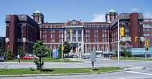
Civic Hospital is a neighbourhood in Kitchissippi Ward in central Ottawa, Canada. It is named after the Ottawa Civic Hospital, which is located in the neighbourhood.
Civic Hospital is bounded on the west by Island Park Drive, on the north by Queensway, on the east by Railway Street and on the south by Carling Avenue.[1] The population as of the Canada 2011 Census was 4,985.[2] The area is part of the Civic Hospital Neighbourhood Association.
The main streets in the neighbourhood are Parkdale Drive, Sherwood Drive, and Holland Avenue ending at Tunney's Pasture
The neighbourhood is served by Carling Station on the O-Train line. It is served by four schools, [Elmdale Public School (JK - Grade 6), Fisher Park Public/Summit Alternative School (Grades 7 -8), Devonshire Public School (JK - 6) and Connaught Public School (JK - 6)], all of which are in adjacent neighbourhoods.
 |
Island Park | Hintonburg | | |
| |
Centretown West | |||
| ||||
| | ||||
| Carlington | Central Experimental Farm |
References
- ↑ http://www.chnaottawa.ca/about-us.html
- ↑ Population calculated by combining Census Tract 5050034.00 with Dissemination area 35061760 and Dissemination Blocks 3506176102, 3506176101, 3506176201