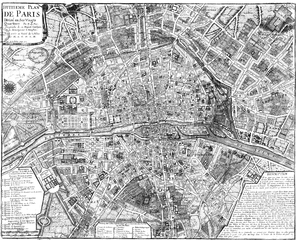
City walls of Paris

Over time, several city walls of Paris were built :
- a Gaulish enclosure (location unknown)
- a Gallo-Roman wall
- two medieval walls, one of which was the Wall of Philippe Auguste
- the Wall of Charles V, extending on the right bank
- the Louis XIII Wall, extending on the western part of the right bank
- the Wall of the Farmers-General, for tax purposes
- the Thiers wall.
Paris was surrounded by walls from ancient times until the twentieth century, except for roughly a century between 1670 (when Louis XIV ordered the demolition of the Louis XIII Wall) and 1785 (when construction began on the Farmers-General Wall).
The initial purpose of these walls was to defend the town and protect the inhabitants; later, with the building of the Farmers-General Wall, they also served to assess taxes for goods sold in Paris. The Philippe Auguste Wall marked the first time Paris had really been protected from attack in any substantial way, and allowed the town to both consolidate and expand, frequently to slightly more than could be contained by the existing walls.
As Paris grew, new houses were built both inside and outside the wall. With time, each wall would be destroyed and its site built up or transformed into a street or boulevard; a new wall would be built further out, to include both the original city and some more houses, and sometimes gardens or vegetable fields.
Only a few traces of these walls survive: a few sections of the Wall of Philippe Auguste, and some pavilions of Claude Nicolas Ledoux which formed part of the Farmers General Wall. However, the walls' influence on modern Paris can be seen in some of its major streets and concentric boulevards:
- The 'Grands boulevards' (main streets), built by replacing the Charles V and Louis XIII Walls;
- The outer boulevards, built in place of the Wall of the Farmers-General;
- The 'boulevards des Maréchaux' (Boulevards of the Marshals, a loop encircling the city consisting of boulevards named for the Marshals of France), built to replace the Thiers Wall;
- The Boulevard périphérique (ring road or beltway), built outside the boulevards des Maréchaux;
- The parallel streets Rue de Cléry and Rue d'Aboukir in the Second Arrondissement mark the route of the Charles V Wall.
Gaulish enclosure
In his Commentaries on the Gallic War, Julius Caesar wrote : "Id est oppidum Parisiorum, quod positum est in insula fluminis Sequanae", indicating that Lutetia (former name of Paris, the town of the tribe of Parisii) was a fortified camp on an island. The identification of this island with the Île de la Cité is possible, but disputed, because it could instead have been Nanterre. The first wall of Paris was therefore probably built by the Gauls and coupled with the natural protection of the river Seine.
Gallo-Roman wall
At the time of the Roman Empire, people and houses spread on the banks of the river, particularly the left one. During the first barbarian invasions, in 285, the people of Lutetia abandoned the left bank and took refuge on the Island of the City. The eastern half of the island was protected by a wall, constructed of rocks collected from the Arènes de Lutèce.
First medieval wall
The existence of an enclosure around the centre of Paris, on the right bank, around the tenth century is probable. During recent research, the INRAP has discovered traces of this enclosure at the corner of rue de l'Arbre-Sec and rue de Rivoli.
Wall of Philippe Auguste

The Wall of Philippe Auguste was built from 1190 to 1213, enclosing 253 hectares on both sides of the river Seine. Many elements were later incorporated into civil buildings or into the Charles V Wall.
Wall of Charles V
The Wall of Charles V was built from 1356 to 1383, during the reign of Charles V and his son and successor Charles VI. The region enclosed on the right bank increased, and now included among other things the mansions of the Marais and the Templar enclosure. The region enclosed on the left bank remained the same as with the Wall of Philippe Auguste. The new city limits totalled 439 hectares across the two banks. During the construction of the Wall of Louis XIII, this wall was partly incorporated into the new wall and partly destroyed.
Louis XIII Wall, sometimes called the "yellow ditches wall"

The Louis XIII Wall was designed by Jacques Lemercier and built between 1633 and 1636. It enlarges the Charles V Wall over the western part of the right bank (now the First and Second Arrondissements).
From 1670 onwards, Louis XIV believed that as a result of his conquests, Paris had been made a secure city. He ordered the wall destroyed and replaced it with the future grands boulevards.
Wall of the Farmers-General
The Wall of the Farmers-General was built in the years after 1785, under the direction of Claude Nicolas Ledoux and at the request of the Ferme Générale. It enclosed 3402 hectares, when the village of Austerlitz was incorporated into Paris in 1818.
Later, this wall was replaced by the second belt of boulevards : Charonne, Ménilmontant, Belleville, La Villette, La Chapelle, Clichy, Batignolles, Courcelles, avenue de Wagram and Iena, streets Benjamin Franklin and Alboni, boulevard de Grenelle, Garibaldi, Pasteur, Montparnasse, Edgar Quinet, Raspail, Saint-Jacques, Auguste Blanqui, Vincent Auriol, Bercy and Picpus. Unlike previous walls, the goal of this wall was not to defend Paris but only to force the payment of taxes on goods entering the capital. It was destroyed when Paris was extended up to the Thiers Walls in 1860.
Thiers Wall
The enclosure was constructed from 1841 to 1844 after a law enacted by Adolphe Thiers. It covered 7802 hectares, along the boulevards des Maréchaux of today and a glacis extending to the location of today's Boulevard Périphérique. It was demolished between 1919 and 1929.
-

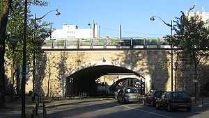
The poterne des Peupliers, the only remaining trace of the Thiers wall
-
The porte de Pantin about 1908
-
The fortifs zone, in Saint-Ouen
Sources
- This page is a translation of its French equivalent.
Bibliography
- Renaud Gagneux et Denis Prouvost, Sur les traces des enceintes de Paris, Parigramme, 2004.
- Jacques Hillairet, Dictionnaire historique des rues de Paris.
- Guy le Hallé, Histoire des fortifications de Paris et leur extension en Île-de-France, Éditions Horvath, 1995.
- Guy le Hallé, in « Paris aux cent villages », mensuel (mai 1975–janvier 1982) :
See also
External links
| Wikimedia Commons has media related to City walls of Paris. |
- (French) Paris walls (with a map)
- (French) Guy Le Hallé, The history of “fortifications” (Thiers wall) à Saint-Ouen
- (French) Malakoff Infos, idem in Malakoff

