City of St Albans
| City of St Albans | ||
|---|---|---|
| Non-metropolitan district, Borough, City | ||
|
| ||
| ||
 St Albans shown within Hertfordshire | ||
| Sovereign state | United Kingdom | |
| Constituent country | England | |
| Region | East of England | |
| Non-metropolitan county | Hertfordshire | |
| Status | Non-metropolitan district, Borough, City | |
| Admin HQ | St Albans | |
| Incorporated | 1 April 1974 | |
| Government | ||
| • Type | Non-metropolitan district council | |
| • Body | St Albans City and District Council | |
| • Leadership | Leader & Cabinet | |
| • MPs |
Anne Main Peter Lilley | |
| Area | ||
| • Total | 62.23 sq mi (161.18 km2) | |
| Area rank | 182nd (of 326) | |
| Population (2011 est.) | ||
| • Total | 141,200 | |
| • Rank | 136th (of 326) | |
| • Density | 2,300/sq mi (880/km2) | |
| • Ethnicity |
90.9% White 4.1% S.Asian 1.7% Black 1.9% Mixed Race 1.4% Chinese or Other | |
| Time zone | GMT (UTC0) | |
| • Summer (DST) | BST (UTC+1) | |
| ONS code |
26UG (ONS) E07000100 (GSS) | |
| OS grid reference | TL148073 | |
| Website |
www | |
The City of St Albans (/sɨnt ˈɔːlbənz/), also known as the City and District of St Albans or District of St Albans, is a local government district, in Hertfordshire, England. It was created in 1974 and since then has held the status of non-metropolitan district and city; the major settlement being St Albans. The local authority is St Albans City Council. It has routes to the M1 motorway via the A414 road (formerly the M10 motorway), and rail routes to London St Pancras and Watford via St Albans City railway station and St Albans Abbey railway station respectively.
History
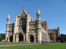
The district was created on 1 April 1974 as a merger of the Municipal Borough of St Albans, the Harpenden Urban District and most of St Albans Rural District. City status had been granted to the municipal borough of St Albans in 1877, following the elevation of St Albans Abbey to cathedral.[1] The status was granted to the entire district by letters patent dated 9 July 1974.[2]
Geography
The district includes the unparished area of St Albans and the civil parishes of Colney Heath, Harpenden, Harpenden Rural, London Colney, Redbourn, St Michael, St Stephen (including the villages of Chiswell Green and Bricket Wood), Sandridge and Wheathampstead.
Nearby places outside the district include Hatfield to the east, Welwyn Garden City to the northeast, Luton and Dunstable to the northwest, Hemel Hempstead to the west, Watford to the southwest and Borehamwood to the south.
Governance
The local authority is St Albans City and District Council, which is based in St Albans. As of the 2014 election no party has a majority, although the Conservative party has exactly half of the seats, with 29 of the 58 councillors.[3]
Civil parishes
Most of the population of the district is within one of nine civil parishes. St Albans is an unparished area in the middle of the district.[4] The unparished area of the City is now overseen by the City Neighbourhoods Committee.
| Parish | Council | Population (2011) | Area (2011) |
|---|---|---|---|
| Colney Heath | Colney Heath Parish Council | 5,962 | 1,119 hectares (4.32 sq mi) |
| Harpenden | Harpenden Town Council | 29,448 | 1,278 hectares (4.93 sq mi) |
| Harpenden Rural | Harpenden Rural Parish Council | 405 | 923 hectares (3.56 sq mi) |
| London Colney | London Colney Parish Council | 9,507 | 513 hectares (1.98 sq mi) |
| Redbourn | Redbourn Parish Council | 5,344 | 1,908 hectares (7.37 sq mi) |
| Sandridge | Sandridge Parish Council | 11,451 | 1,518 hectares (5.86 sq mi) |
| St Michael | St Michael Parish Council | 477 | 2,120 hectares (8.2 sq mi) |
| St Stephen | St Stephen Parish Council | 13,865 | 2,329 hectares (8.99 sq mi) |
| Wheathampstead | Wheathampstead Parish Council | 6,410 | 2,599 hectares (10.03 sq mi) |
| Total parishes | 82,869 | 14,307 hectares (55.24 sq mi) | |
| St Albans (unparished) | City Neighbourhood Committee | 57,795 | 1,811 hectares (6.99 sq mi) |
| Total City of St Albans | St Albans City Council | 140,664 | 16,118 hectares (62.23 sq mi) |
Economy
The City and District of St Albans has a strong local economy, a highly skilled workforce, an excellent location for rail, road and airports and is seen by many employers as a desirable place to be. The District also benefits from the proximity of the University of Hertfordshire, based close by at Hatfield, which is one of the country’s leading business orientated universities.
Well-known firms such as Deloitte, Spreadex, AECOM, PricewaterhouseCoopers and Premier Foods all have large office bases in the area. It also has many distributive industries such as the Sainsbury's Retail Distribution Centre at London Colney which employs over 600 staff.[5]
Demography
The 2001 census showed a population of 129,005 with a split of 50.84% to 49.16% female to male. The Office for National Statistics mid-2012 estimates the population at 138,800. The age split in the 2001 census recorded 20.5% children, 64,5% of working age (16-64) and 14.9% older people (65+).[6]
86.9% of St Albans residents are White British, with 4.3% identified as Other White, 2% Irish, and 1.3% Bangladeshi. The majoriy of St Albans residents identify themselves as Christians (71%), followed by no religion or religion not stated (24.1%), Muslim (2.6%) and Jewish (0.9%).[6]
In terms of employment, St Albans has a highly skilled workforce, having the 4th highest proportion of managers, senior officials and professional occupations in the country. It has lower than the national average unemployment figures, and the lowest level in Hertfordshire.[6]
St Albans has a very low proportion of people reporting they are permanently sick or disabled (2.8%) compared with the proportion nationally (5-6%).[6]
In 2001 nearly 50% of residents (aged 16–64) hold a degree or equivalent and the average weekly earnings of £724.40 is 44% higher than the national average.[6]
Twin towns
St Albans is twinned with:[7]
 Fano, Italy
 Nyíregyháza, Hungary
 Nevers, France
 Odense, Denmark
  Worms, Germany
 Nieuwleusen, Netherlands
 Sylhet, Bangladesh
In addition, there are friendship links with:
References
- ↑ The London Gazette: no. 24502. p. 5185. 11 September 1877. Retrieved 12 May 2010.
- ↑ The London Gazette: no. 46352. p. 7920. 24 September 1974. Retrieved 18 April 2008.
- ↑ "St Albans". BBC News Online. Retrieved 3 February 2015.
- ↑ http://www.stalbans.gov.uk/Images/A3_District_Parishes_VectorMapDistrict_tcm15-34201.pdf
- ↑ "Mapped: St Albans Econmoy Report 2011" (PDF). Retrieved 1 September 2012.
- ↑ 6.0 6.1 6.2 6.3 6.4 "Mapped: St Albans Community Profile". Retrieved 1 September 2012.
- ↑ http://www.stalbans.gov.uk/council-and-democracy/overview/town-twinning/
| ||||||||||||||||||||||||||||

| ||||||||||||||||||
| ||||||||||||||||||||||||||||||||||||||||||||||||||||||||||||||||||||||||||||||||