City of Canterbury
| City of Canterbury | |
|---|---|
| Non-metropolitan district, Borough, City | |
|
| |
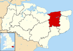 Canterbury shown within Kent | |
| Sovereign state | United Kingdom |
| Constituent country | England |
| Region | South East England |
| Non-metropolitan county | Kent |
| Status | Non-metropolitan district, Borough, City |
| Admin HQ | Canterbury |
| Incorporated | 1 April 1974 |
| Government | |
| • Type | Non-metropolitan district council |
| • Body | Canterbury City Council |
| • Leadership | Leader & Cabinet (Conservative) |
| • MPs |
Julian Brazier Roger Gale |
| Area | |
| • Total | 119.24 sq mi (308.84 km2) |
| Area rank | 137th (of 326) |
| Population (2011 est.) | |
| • Total | 150,600 |
| • Rank | 121st (of 326) |
| • Density | 1,300/sq mi (490/km2) |
| • Ethnicity |
93.4% White 2.2% S.Asian 1.6% Chinese and other 1.4% Mixed Race |
| Time zone | GMT (UTC0) |
| • Summer (DST) | BST (UTC+1) |
| ONS code |
29UC (ONS) E07000106 (GSS) |
| OS grid reference | TR145575 |
| Website |
www |
The City of Canterbury (RP: /ˈkæntəbərɪ/ or /ˈkæntəbrɪ/[1]) is a local government district with city status in Kent, England. The main settlement in the district is Canterbury.
History
The district was formed on April 1st, 1974 by the merger of the existing city of Canterbury with the Whitstable and Herne Bay Urban Districts, and Bridge-Blean Rural District. The latter district entirely surrounded the city; the urban districts occupied the coastal area to the north.
Politics
Elections to the city council are held every four years, all of the 50 seats on the council being elected. After being under no overall control for a number of years, the Conservative party gained a majority at the 2007 election and increased it in the 2011 election.
Following the United Kingdom local elections, 2011 and subsequent by-elections,[2][3][4] and defections between groups the political composition of Canterbury council is as follows:
| Year | Conservative | Liberal Democrat | Labour Party | UKIP |
|---|---|---|---|---|
| 2014 | 34 | 11 | 3 | 2 |
Geography
Within the district are the towns of Herne Bay and Whitstable, which with the parishes and the cathedral city itself, make up the 'City of Canterbury' district. There are 26 parishes within the district, as follows:[5]
- Adisham
- Barham
- Bekesbourne with Patrixbourne
- Bishopsbourne
- Blean
- Bridge
- Chartham
- Chestfield
- Chislet
- Fordwich: has town status
- Hackington
- Harbledown and Rough Common
- Herne and Broomfield
- Hoath
- Ickham
- Kingston
- Littlebourne
- Lower Hardres
- Petham
- Sturry
- Thanington Without
- Upper Hardres
- Waltham
- Westbere
- Wickhambreaux
- Womenswold
Swalecliffe is an unparished area within the district.
The area is largely rural, with a coastal strip taken up by the almost unbroken spread of seaside towns and beautiful beaches from Seasalter, west of Whitstable, to Herne Bay, Kent. Between them and the city, the hills rise into the well wooded historic Blean, south of which is the Great Stour flowing from its source beyond Ashford. The city of Canterbury stands upon this river.
Twin towns
The district participates in the Sister Cities programme, with links[6] to Bloomington-Normal, USA and Vladimir, Russia.
Several towns and villages within the City of Canterbury district have their own twinning arrangements;[6] see in particular Canterbury, Whitstable and Herne Bay.
See also
References
- ↑ "Canterbury". Collins Dictionary. n.d. Retrieved 24 September 2014.
- ↑
- ↑ "Declaration of Result of Poll : Canterbury : Election of a City Councillor for Seasalter" (PDF). Canterbury.gov.uk. 2 May 2013. Retrieved 2015-03-07.
- ↑ "Declaration of Result of Poll : Canterbury : Election of a City Councillor for Seasalter" (PDF). Canterbury.gov.uk. 19 September 2013. Retrieved 2015-03-07.
- ↑ "Parish Councils". Canterbury City Council. 2008. Retrieved 5 September 2010.
- ↑ 6.0 6.1
External links
- Canterbury City Council
- Population breakdown
- City of Canterbury councillors listed by ward, as of 2010
| ||||||||||||||||||||||||||||||||||||||||

| ||||||||||||||||||