Circle Drive
| Route information | |
|---|---|
| Maintained by City of Saskatoon | |
| Length: | 26.50 km (16.47 mi) |
| Existed: | 1961 – present |
| Major junctions | |
| Orbital around Saskatoon, Saskatchewan, Canada | |
| Saskatchewan Highway 5, Saskatchewan Highway 11, Saskatchewan Highway 12, Saskatchewan Highway 14, Saskatchewan Highway 16 | |
| Highway system | |
| Provincial highways in Saskatchewan | |

Circle Drive is a major road constructed as a ring road in Saskatoon, Saskatchewan, Canada. The northeastern portion of the road is part of the Yellowhead Highway. It was first conceived in 1913 by the city commissioner and completed exactly 100 years later in 2013.[1]
History
Construction of a ring road in Saskatoon was first proposed in 1913 by city commissioner Christopher J. Yorath. He conceived the first comprehensive town plan, which included inner and outer "encircling boulevards". Parts of the present-day roadway follow the course Yorath laid out, though some route proposals were rejected, such as one for the southern leg that would have taken the roadway over an island south of present-day Saskatoon that, years later, was named in honour of Yorath.[2] It wasn't until the 1950s as the city expanded outward that the present roadway corridor was established. Construction funding, originally estimated at $10 million, was allotted and construction began in 1961.[3]
Rather than the complete route being built at once, Circle Drive was built in sections, as required by traffic conditions and allowed by available funding. As a result, it would take 52 years for the project to be completed.
The first sections to be built were a northwest segment between Warman Road and 11th Street West, which initially included only a single interchange at Idylwyld Drive (formerly known as Avenue A); some of the route made use of a previously existing arterial commercial road, 42nd Street (as a result, the stretch of Circle Drive between Avenue C and Millar Avenue is often referred to as 42nd Street). The southeast segment, from Lorne Avenue to College Drive, was constructed concurrently with the Idylwyld Freeway, a connector from Circle Drive into the downtown core. Not including the Idylwyld Freeway, only two interchanges were initially built on the southeast leg: a limited-access one at 14th Street, and a large cloverleaf interchange at the junction of the realigned highways 16 and 11. In lieu of an interchange at 8th Street, a large traffic circle or roundabout was constructed.
1983 extension and north bridge
For more than a decade the two sections of Circle Drive sat apart. The next portion of the roadway completed was the northeast quadrant, from College Drive to Warman Road, connecting the two extant sections. This included the construction of the Circle Drive Bridge (aka the North Bridge) across the South Saskatchewan River and was completed in 1983 after several years of construction. The original project involved interchanges at Warman Road and 108th Street; over the next 20 years additional interchanges were constructed at Attridge Drive/Preston Avenue North and College Drive. Also during the 1980s, the northwest leg of Circle Drive added an interchange at 33rd Street, while the 8th Street traffic circle in the southeast was removed after years of complaints and accidents, and by the 1990s an interchange was constructed as a replacement. Also in the 1990s an interchange was added at Taylor Street's junction with Circle Drive.
A few years after its completion, the northeast extension was designated the through route for the Yellowhead Highway, replacing the previous route through downtown along Idylwyld Drive.
In the early 2000s, in preparation for construction of the southwest leg, a major interchange was added where Circle Drive intersected several major roads: 22nd Street West, Fairlight Drive and Confederation Drive, replacing a complex series of traffic lights. Also in partial preparation for the extension (as well as residential and commercial development), an interchange at Clarence Avenue South was added in the late 2000s.
2013 extension and south bridge
The last remaining southwest section of Circle Drive, between 11th Street West and Lorne Avenue, including the Circle Drive South Bridge, opened to traffic on July 31, 2013, after several years of construction and a delay of nearly a year. Approximately 7 km in length, it connects the C.N. Industrial area to the Holiday Park neighbourhood, travelling through property annexed from the Saskatoon Golf and Country Club.[4][5] It includes a new bridge, located just north and parallel to the Grand Trunk Bridge.[6][7]
The bridge has six traffic lanes and a pedestrian walkway suspended underneath, similar to the north bridge. National and provincial funding each amounted to $172 million and the City of Saskatoon committed $70.5 million towards the project.[8] The total cost of the project is estimated at $272.5 million.[6] The bridge has yet to be given a formal name, with the City announcing in June 2013 that it planned to hold a naming contest to determine a permanent name for the structure; for now, it is officially called the Circle Drive South Bridge.
The City of Saskatoon hired a private contractor to build the bridge. Three companies submitted proposals: PCL Construction, Peter Kiewet Sons and Graham Construction/Flatiron.[9] The Graham/Flatiron bid was selected on March 29, 2010. Construction of the bridge and associated roadways was expected to be complete by September 30, 2012.[6] However, record rainfall, high water tables and an early snowfall made that deadline unfeasible, and the roadway ultimately did not open until July 31, 2013.
Environment Canada and Fisheries and Ocean oversaw environmental impacts on the river. The project included four new interchanges: one at Secondary Highway 762 (aka Valley Road), one at 11th Street West which utilizes some of the land area given up by the Maple Leaf Foods building demolition in 2010,[9] and additional interchanges at Highway 219 (aka Lorne Avenue) and the Idylwyld Freeway. In the later stages of construction, construction began on an interchange along the older southeast section of Circle Drive at its intersection with Preston Avenue South; this was completed several months after the southwest extension and marked the completion of the Circle Drive project.
The Holiday Park golf course needed to re-landscape two holes on the golf course, as holes 6 and 7 were affected. The southwest and southern periphery of Diefenbaker Park was also impacted as that portion of the park was taken over by the freeway. Some roadways in Montgomery Place and Holiday Park Industrial were also realigned and the at-grade intersection at Circle and Clancy Drive was also revised. Another impact of the project is a new rail switching yard near 11th Street and Dundonald Avenue. In 2010, the City of Saskatoon signed a non-binding agreement in principle with the Canadian National Railway and Canadian Pacific Railway to move railcar switching out of the downtown Central Industrial neighbourhood.[10]
Additional road revisions were required as part of the project: 11th Street West, westbound from the new interchange with Circle, was replaced with the 11th Street West Bypass (the original road was converted into a cul-de-sac). Several streets within the South West Industrial and C.N. Industrial subdivisions were also realigned or shortened. The portion of Dundonald Avenue between Mountbatten Street and Valley Road was designated for closure; this required the construction of a new access road off Valley Road connecting to the city landfill while Valley Road itself was realigned to connect directly with Circle Drive (previously it had linked with Dundonald Avenue). Development of the Circle Drive/Valley Ridge interchange also required the permanent closure of the Fletcher Road access point into South West Industrial via Dundonald, leading to city planners adding a new roadway, Dawes Avenue to provide an extra access to 11th Street and, in turn, Circle Drive.
The first portion of the southwest extension to open was 11th Street to Valley Road, which was open by late spring of 2013.
Future development
Although the circle is now "closed", the City of Saskatoon is investigating future improvements to older parts of the freeway, including revisions to the aged Idylwyld Drive North/Circle Drive interchange and finding ways to deal with traffic congestion along the non-freeway "42nd Street" section of the road. As of October 2013 the City's Projected Growth Concept Plan map shows a proposed interchange at Airport Drive. There also remain several at-grade intersections along the freeway portion of Circle Drive at Laurier Drive and Clancy Drive which will need to be addressed in the future in order to create "freeflow" conditions along the non-42nd Street portion of the road.
In addition, as of the end of 2014 the south bridge has yet to be given its final name (with Circle Drive South being identified as only an interim identifier).
Interchanges
As of 2004, the Circle Drive Bridge portion of the road was carrying up to 50,000 vehicles per day, more than twice the volume from when it opened.[11] Due to the greatly increased traffic the bridge was significantly expanded in 2007.[12] Over the years, a number of at-grade intersections were converted to grade-separated interchanges to improve traffic flow.[13] They include:
- Idylwyld Drive North (formerly known as Avenue A) – 1960s
- 33rd Street – November 10, 1980 (expanded in summer 1992)
- Warman Road – July 1, 1983 (coinciding with the opening of Circle Drive Bridge)
- Taylor Street – September 16, 1996
- 8th Street – October 31, 1999 – initially constructed as a large traffic circle in the late 1960s, this traffic control device proved unpopular and was removed in the mid-1980s and eventually replaced by an interchange in 1999.
- Attridge Drive/Preston Avenue North – October 1, 2001
- 22nd Street/Confederation Drive/Fairlight Drive – October 28, 2002
- College Drive – October 4, 2006
- Clarence Avenue – November 20, 2007
- Preston Avenue – Completed in autumn of 2013[14]
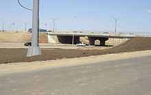
There are also purpose-built half-diamond interchanges at 14th Street East and 108th Street, and a cloverleaf interchange at highways 11 and 16. Between Millar Avenue and Avenue C North, Circle Drive downgrades from a freeway to an arterial road, with regular signalized intersections and driveway-accessed businesses. Additional at-grade intersections are located at Circle Place (no signals, eastbound access only), Airport Drive (signals; northeastbound traffic free-flow), Laurier Drive (signals; northbound traffic free-flow), and Clancy Drive (signals, northbound traffic free-flow). A short spur of Circle Drive between the Idylwyld Freeway and Lorne Avenue formerly included signals at Lorne and at-grade intersections at Jasper Avenue and Melville Street, but these were removed as part of the southwest construction (see below).
As noted above, the junction of 8th Street and Circle Drive was originally, in the late 1960s, constructed as a large roundabout dubbed the "Traffic Circle". The first such construction of its kind in Saskatchewan, motorists found it difficult to navigate, leading to local media airing advisories on how to use it. The site of many accidents over the years, and dubbed the most accident-prone location in the city,[15] the circle was ultimately dismantled in the 1980s and replaced with a standard at-grade intersection for a decade until a standard diamond interchange was constructed.
Exits and intersections
This is a diagram of present exits and intersections on Circle Drive, beginning clockwise from 11th Street West:
| Circle Drive Exits | ||||||||||||||||||||||||||||||||||||||||||||||||||||||||||||||||||||||||||||||||||||||||||||||||||||||||||||||||||||||||||||||||||||||||||||||||||||||||||||||||||||||||||||||||||||||||||||||||||||||||||||||||||||
|---|---|---|---|---|---|---|---|---|---|---|---|---|---|---|---|---|---|---|---|---|---|---|---|---|---|---|---|---|---|---|---|---|---|---|---|---|---|---|---|---|---|---|---|---|---|---|---|---|---|---|---|---|---|---|---|---|---|---|---|---|---|---|---|---|---|---|---|---|---|---|---|---|---|---|---|---|---|---|---|---|---|---|---|---|---|---|---|---|---|---|---|---|---|---|---|---|---|---|---|---|---|---|---|---|---|---|---|---|---|---|---|---|---|---|---|---|---|---|---|---|---|---|---|---|---|---|---|---|---|---|---|---|---|---|---|---|---|---|---|---|---|---|---|---|---|---|---|---|---|---|---|---|---|---|---|---|---|---|---|---|---|---|---|---|---|---|---|---|---|---|---|---|---|---|---|---|---|---|---|---|---|---|---|---|---|---|---|---|---|---|---|---|---|---|---|---|---|---|---|---|---|---|---|---|---|---|---|---|---|---|---|---|
| ||||||||||||||||||||||||||||||||||||||||||||||||||||||||||||||||||||||||||||||||||||||||||||||||||||||||||||||||||||||||||||||||||||||||||||||||||||||||||||||||||||||||||||||||||||||||||||||||||||||||||||||||||||
References
- ↑ Hamilton, Charles (2013-08-01). "Police christen bridge with ticket blitz". The StarPhoenix. Postmedia Network. Retrieved 2013-08-27.
- ↑ Kerr, Don; Stan Hanson (1982). Georgina Lewis, ed. Saskatoon: The First Half-Century. NeWest Press. p. 286. ISBN 0-920316-37-9.
- ↑ "Expect Early Start on Circle Drive Project". The StarPhoenix. 1961-04-22. Retrieved 2013-01-19.
- ↑ "Circle Drive South Bridge". Retrieved 2008-12-24.
- ↑ "River Crossing Studies". City of Saskatoon. Retrieved 2010-11-04.
- ↑ 6.0 6.1 6.2 "Circle Drive South Project". City of Saskatoon. Retrieved 2010-11-04.
- ↑ "Circle Drive South River Crossing – Complete Alignment" (PDF). City of Saskatoon – Infrastructure Services. March 12, 2009. Retrieved 2009-12-08.
- ↑ Nickel, Rod (June 21, 2008). "Bridge builders". The StarPhoenix. pp. A1. Retrieved 2010-11-04.
- ↑ 9.0 9.1 Hutton, David (2009-05-30). "Builders to receive details on bridge project". The StarPhoenix (CanWest). Retrieved 2010-11-04.
- ↑ Hutton, David (June 23, 2009). "City, CP agree to study move of downtown yard". The StarPhoenix (Canwest). p. A3. Retrieved 2010-11-04.
- ↑ "(pdf) Circle Drive South River Crossing, Questions and Answers" (PDF). City of Saskatoon. June 2004. Archived from the original (PDF) on October 12, 2007. Retrieved 2007-11-28.
- ↑ "Circle Drive Widening". City of Saskatoon. Retrieved 2007-11-29.
- ↑ "The City of Saskatoon Municipal Manual 2007" (PDF). City of Saskatoon. Archived from the original (PDF) on October 26, 2007. Retrieved 2007-12-12.
- ↑ "Circle Drive and Preston Avenue Interchange Information Session on October 19". City of Saskatoon. Retrieved 2010-11-04.
- ↑ Robinson, Art (December 29, 1979). "1980 to see start on long-awaited 42nd Street Bridge". The StarPhoenix. Retrieved 2013-01-19.