Cimarron River (Gunnison River)
| Cimarron River[1] | |
|---|---|
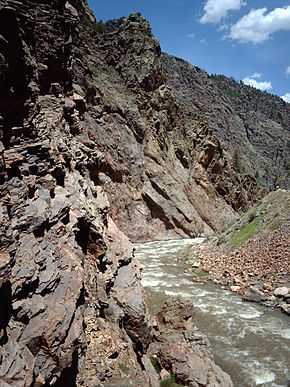 Cimarron River Gorge | |
| Origin |
Confluence of East Fork and Middle Fork 38°12′15″N 107°31′11″W / 38.20417°N 107.51972°W |
| Mouth |
Confluence with Gunnison River 38°27′11″N 107°32′38″W / 38.45306°N 107.54389°WCoordinates: 38°27′11″N 107°32′38″W / 38.45306°N 107.54389°W |
| Progression | Gunnison—Colorado |
| Source elevation | 9,022 ft (2,750 m) |
| Mouth elevation | 6,755 ft (2,059 m) |
The Cimarron River is a 22.0-mile-long (35.4 km)[2] tributary that joins the Gunnison River in Curecanti National Recreation Area near Cimarron, Colorado. The river's source is the confluence of two forks near Silver Jack Reservoir in the Uncompahgre National Forest.
A Denver & Rio Grande Western narrow gauge trestle is located near the confluence of the Cimarron and the Gunnison.
See also
References
- ↑ "Cimarron River". Geographic Names Information System. United States Geological Survey. Retrieved 2011-01-27.
- ↑ U.S. Geological Survey. National Hydrography Dataset high-resolution flowline data. The National Map, accessed March 18, 2011