Cima Valdritta
| Cima Valdritta | |
|---|---|
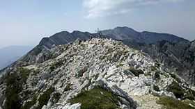 Cima Valdritta summit | |
| Elevation | 2,218 m (7,277 ft)[1] |
| Prominence | 1,950 m (6,400 ft)[2] |
| Listing | Ultra |
| Location | |
 Cima Valdritta | |
| Range | Alps, Brescia and Garda Prealps |
| Coordinates | 45°43′35″N 10°50′38″E / 45.72639°N 10.84389°ECoordinates: 45°43′35″N 10°50′38″E / 45.72639°N 10.84389°E[2] |
| Climbing | |
| Easiest route | rock/snow climb |
Cima Valdritta is the highest summit of the Monte Baldo mountain range and thereby part of the Garda Mountains in northern Italy.
Morphology
The Cima Valdritta summit is the highest peak of the Monte Baldo range,[3] that roughly extends from north to south. Other prominent peaks in the range are Punta Telegrafo to the south and Cima delle Pozzette to the north. On the western slopes is the impressive Valdritta cirque. The summit is rocky and just above the tree line.
Climbing
The summit can be reached from the south via Punta Telegrafo, from the north as a long hike over the Monte Baldo mountain ridge, from the west through the Valdritta cirque or fastest from the east, a steep track starting at the country road SP3.
-
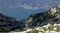
View into Valdritta cirque down to Lake Garda
See also
References
- ↑ "Cima Valdritta, Italy". Peakbagger.com. Retrieved 2014-07-28.
- ↑ 2.0 2.1 "European Ultra-Prominences". Peaklist.org. Retrieved 2014-07-28.
- ↑ Kompass topographical map 102, Lake Garda, Monte Baldo (http://www.kompass.at)
External links
![]() Media related to Cima Valdritta at Wikimedia Commons
Media related to Cima Valdritta at Wikimedia Commons