Churi Wiqu (Tacna)
For the mountain on the border of the Moquegua Region and the Puno Region, Peru, see Churi Wiqu (Moquegua-Puno).
| Churi Wiqu | |
|---|---|
 | |
| Elevation | 5,000 m (16,000 ft)[1] |
| Location | |
 Churi Wiqu Peru | |
| Location | Peru, Tacna Region, Candarave Province, Tarata Province |
| Range | Andes |
| Coordinates | 17°7′33″S 70°5′50″W / 17.12583°S 70.09722°WCoordinates: 17°7′33″S 70°5′50″W / 17.12583°S 70.09722°W |
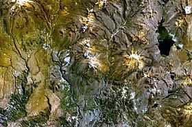
Churi Wiqu (Aymara churi dull yellow, wiqu a corner in a house, a mountain cove,[2] "dull yellow mountain cove", hispanicized spelling Choreveco) is a mountain in the Andes of southern Peru, about 5,000 metres (16,404 ft) high. It is located in the Tacna Region, Candarave Province, Candarave District, and in the Tarata Province, Susapaya District.[1] Churi Wiqu lies northeast of the volcano Yukamani. It is situated between the mountain Ch'iyar Jaqhi in the west and the lake Wilaquta in the east.
References
- ↑ 1.0 1.1 escale.minedu.gob.pe - UGEL map of the Candarave Province (Tacna Region)
- ↑ Radio San Gabriel, "Instituto Radiofonico de Promoción Aymara" (IRPA) 1993, Republicado por Instituto de las Lenguas y Literaturas Andinas-Amazónicas (ILLLA-A) 2011, Transcripción del Vocabulario de la Lengua Aymara, P. Ludovico Bertonio 1612 (Spanish-Aymara-Aymara-Spanish dictionary)