Chung-guyok
| Chung-guyŏk | |
|---|---|
| Korean transcription(s) | |
| • Hangul | 중구역 |
| • Hanja | 中區域 |
| • Revised Romanization | Jung-guyeok |
| • McCune–Reischauer | Chung-guyŏk |
|
| |
| Country | North Korea |
| Administrative divisions | 19 administrative dong |
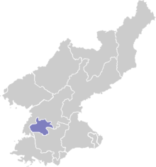
Chung-guyŏk (Central District) is one of the 19 guyok which constitute the city of Pyongyang, North Korea. The district is located in the center of the city, between the Potong and Taedong Rivers, and is bordered to the north by Moranbong-guyok, to the northwest by Potonggang-guyok, and to the south by Pyongchon-guyok.
Overview
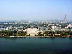
As the centre of Pyongyang, the district holds many of the city's most important buildings. The famous Kim Il-sung Square is located along the banks of the Taedong river, together with the Grand People's Study House, which is the national library of North Korea.[1] Chung-guyok was once the historical centre of Pyongyang, and was almost completely obliterated during the Korean War by American bombing. Vestiges of the old city can still be seen, and the district is home to several of North Korea's National Treasures, including the rebuilt Potong and Taedong Gates, the Pyongyang Bell, the Ryongwang Pavilion, and the Sungryong and Sungin Halls.[2] Other buildings include the Koryo Hotel, Taedonggang Hotel, Pyongyang First Department Store, The National Stamp museum of the DPRK, The Pyongyang Central Children's palace and Taedongmoon Cinema.
The Pyongyang Metro runs through this district, with stops at Yonggwang, Ponghwa and Sungri Stations.
Executive offices of the North Korean government and its industry are located in the area. This is also the headquarters borough of the Central Committee of the Workers' Party of Korea.
Economy
Air Koryo has a booking office in Tongsŏng-dong.[3]
Administrative divisions
Chung-guyok is divided into nineteen administrative districts known as dong.[4]
| Chosŏn'gŭl | Hancha | |
|---|---|---|
| Changgwang-dong | 창광동 | 蒼光洞 |
| Chongro-dong | 종로동 | 鍾路洞 |
| Chungsong-dong | 중성동 | 中城洞 |
| Haebangsan-dong | 해방산동 | 解放山洞 |
| Kyogu-dong | 교구동 | 橋口洞 |
| Kyongrim-dong | 경림동 | 敬臨洞 |
| Kyongsang-dong | 경상동 | 慶上洞 |
| Mansu-dong | 만수동 | 萬壽洞 |
| Oesong-dong | 외성동 | 外城洞 |
| Otan-dong | 오탄동 | 烏灘洞 |
| Potongmun-dong | 보통문동 | 普通門洞 |
| Ryonhwa-dong | 련화동 | 蓮花洞 |
| Ryusong-dong | 류성동 | 柳城洞 |
| Sochang-dong | 서창동 | 西蒼洞 |
| Somun-dong | 서문동 | 西門洞 |
| Taedongmun-dong | 대동문동 | 大同門洞 |
| Tongan-dong | 동안동 | 東岸洞 |
| Tonghung-dong | 동흥동 | 東興洞 |
| Tongsong-dong | 동성동 | 東城洞 |
| Yokjon-dong | 역전동 | 驛前洞 |
References
- ↑ The Grand People's Study House of the DPR of Korea. UN System Depository Libraries. Retrieved on August 31, 2008.
- ↑ http://north.nricp.go.kr/nrth/kor/cul/cul_lis.jsp?area_cd=11000000
- ↑ "Contact." Air Koryo. Retrieved on August 6, 2009.
- ↑ http://nk.joins.com/map/i002.htm
| ||||||||||||
Coordinates: 39°00′00″N 125°44′24″E / 39.00000°N 125.74000°E

