Chott el Hodna
| Chott el Hodna شط الحضنة | |
|---|---|
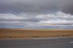 Landscape of the Chott el Hodna | |
| Location | Hodna |
| Coordinates | 35°26′N 4°46′E / 35.44°N 4.76°ECoordinates: 35°26′N 4°46′E / 35.44°N 4.76°E |
| Type | Endorheic salt lake |
| Basin countries | Algeria |
| Max. length | 77 km (48 mi) |
| Max. width | 16 km (9.9 mi) |
| Surface area | 76,000 ha |
| Surface elevation | 394 m above sea level |
The Chott el Hodna (Arabic: شط الحضنة) is a very shallow saline lake in Algeria. It is located within an endorheic basin in the Hodna region, towards the eastern end of the Hautes Plaines.[1] The Chott el Hodna includes seasonal brackish and saline pools and marshes, but the central zone of the lake is characterized by a complete absence of vegetation.
J. Despois argues that the Chott el Hodna is not a proper Chott, but a Sebkha.[2]
Ecology
The chott area provides an important habitat for certain endangered species such as the Cuvier's gazelle, the marbled duck and different kinds of bustards, as well as indigenous fish species. The Chott el Hodna was declared a Ramsar site on 2 February 2001.[3]
See also
References
- ↑ "Chott el-Hodna (lake, Algeria)". Encyclopaedia Britannica. Retrieved 21 June 2013.
- ↑ J. Despois, Le Hodna (Algérie)
- ↑ The Annotated Ramsar List: Algeria