Chopicalqui
| Chopicalqui | |
|---|---|
 | |
| Elevation | 6,354 m (20,846 ft) |
| Translation | Fits in the center (Quechua) |
| Location | |
 Chopicalqui Peru | |
| Location | Yungay Province, Peru |
| Range | Cordillera Blanca (Andes) |
| Coordinates | 9°05′12″S 77°34′26″W / 9.08667°S 77.57389°WCoordinates: 9°05′12″S 77°34′26″W / 9.08667°S 77.57389°W |
| Climbing | |
| First ascent | August 3, 1932 by H. Hoerlin, E. Schneider, P. Borchers, E. Hein |
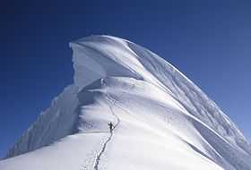
Chopicalqui (Ancash Quechua kallki ravine)[1] is a mountain in the Cordillera Blanca (Spanish for "white range") in the Andes of Peru. With a summit elevation of 6,354 meters (20,846 feet) above sea level it is one of the highest peaks of the Cordillera Blanca.
It lies in the Yungay Province of the Ancash Region between the mountains Huascarán and Yanarahu.
Climbing
The standard climbing route is the Southwest Ridge, a moderate snow climb that is popular with climbers and can be crowded at times. It possesses a difficulty rating of PD+/AD- on the French System for grading alpine routes but deep snow on the summit slopes causes most failures for parties attempting the ridge.
Other established climbing routes include the following:
- Southeast Ridge (alpine grade TD-).
- East Face Direct (alpine grade TD).[2]
References
- ↑ Leonel Alexander Menacho López, Yachakuqkunapa Shimi Qullqa, Anqash Qhichwa Shimichaw (Ministerio de Educación), Wordbook Ancash Quechua-Spanish: Kallki. - Encañada.
- ↑ B. Johnson, Classic Climbs of the Cordillera Blanca Peru, 2009