Chixoy River
| Chixoy River (Río Negro) | |
|---|---|
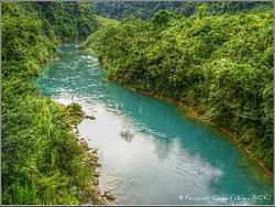
|
Chixoy river in Alta Verapaz (2009) | |
| Origin |
Guatemala (Huehuetenango, El Quiché) |
| Mouth | Tributary of the Salinas river |
| Basin countries | Guatemala |
| Source elevation |
2,000 m (6,600 ft) 15°16′13″N 91°24′49″W / 15.27028°N 91.41361°W |
| Mouth elevation |
160 m (520 ft) 16°4′7″N 90°26′28″W / 16.06861°N 90.44111°W |
| Avg. discharge |
551 m3/s (19,500 cu ft/s) at San Agustín Chixoy |
| Basin area | 1,250 km2 (480 sq mi)[1] |
The Chixoy River or Río Negro is a river in Guatemala. The river is called Río Negro from its sources in the highlands of Huehuetenango and El Quiché until it reaches the Chixoy hydroelectric dam (located at 15°16′54″N 90°29′27″W / 15.281536°N 90.490952°W), where the Río Salamá and Rio Carchela converge with the Río Negro. After the Chixoy dam, the river is called Río Chixoy and flows northwards, marking the departmental limits between Alta Verapaz and El Quiché, until it reaches the border with Mexico. From there on it continues along the border for another 113 km as the Salinas river until it finally converges with the Río la Pasión (at 16°28′52″N 90°32′39″W / 16.481193°N 90.544167°W) to form the Usumacinta river which flows into the Gulf of Mexico.
The Chixoy river's water discharge of 551 m3/s is Guatemala's highest. This was one of the main reasons for selecting this river for the construction of the Chixoy Hydroelectric dam. Guatemala's National Institute for Electricity (INDE) is planning the construction of another hydroelectric dam on the Chixoy river. The proposed location of the Xalalá hydroelectric dam is situated at 15°41′34″N 90°47′11″W / 15.692833°N 90.786361°W.[2] in the municipality of Ixcán, El Quiché.
See also
- Chixoy hydroelectric dam
- Río Negro Massacre
References
- ↑ INSIVUMEH. "Principales ríos de Guatemala".
- ↑ INDE. "Proyecto Hidroeléctrico Xalalá".