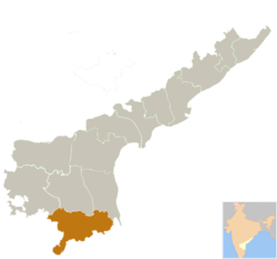
Chittoor district
| Chittoor district చిత్తూరు జిల్లా | |
|---|---|
| District | |
 | |
| Country | India |
| State | Andhra Pradesh |
| Region | Rayalaseema |
| Area | |
| • Total | 15,359 km2 (5,930 sq mi) |
| Population (2011) | |
| • Total | 4,170,468[1] |
| Languages | |
| • Official | Telugu |
| Time zone | IST (UTC+5:30) |
| ISO 3166 code | ISO 3166-2:IN |
| Headquarters | Chittoor |
| Largest city | Tirupati |
| Sex ratio | M-50%/F-40% ♂/♀ |
| Literacy | 72.96% |
| Lok Sabha seats | 2 |
| Vidhan Sabha seats | 14 |
Chittoor district (![]() pronunciation ), also known as Chittur, is a district in Rayalaseema region of Andhra Pradesh, India. The district headquarters is Chittoor and the largest city is Tirupati. The district has a population of 4,170,468 according to 2011 census of India.[2] Chittoor district has many major temples including Tirupati, Kanipakam and Sri Kalahasti temples. It lies in the Poini river valley of southernmost Andhra Pradesh along the Chennai - Bangalore section Chennai-Mumbai highway. It is a major market center for mangoes, grains, sugarcane, and peanuts.
pronunciation ), also known as Chittur, is a district in Rayalaseema region of Andhra Pradesh, India. The district headquarters is Chittoor and the largest city is Tirupati. The district has a population of 4,170,468 according to 2011 census of India.[2] Chittoor district has many major temples including Tirupati, Kanipakam and Sri Kalahasti temples. It lies in the Poini river valley of southernmost Andhra Pradesh along the Chennai - Bangalore section Chennai-Mumbai highway. It is a major market center for mangoes, grains, sugarcane, and peanuts.
Etymology
The word Chittoor is combination of two Tamil words Chit (=small) and ooru (=place), which translates to small town. In ancient days, Chittoor was part of Tamil country of Thondai Nadu.[3]
History
Chittoor District was formed on 1 April 1911, taking Chittoor, Palamaneru, Chandragiri from the then North Arcot District of Madras State and Madanapalli, Vayalpadu from Kadapa and Punganur, Sri Kalahasti, Karvetinagar from Zamindari provinces to form united Chittoor district. Chandragiri, a suburban area of Tirupati served as fourth capital of Vijayanagar empire.
Geography

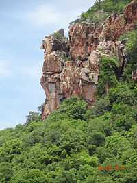
Chittoor is a part of Rayalaseema region of Andhra Pradesh.[4] The district occupies an area of 15,359 square kilometres (5,930 sq mi).[5][6] The district is bounded by Anantapur District to the northwest, Kadapa District to the north, Nellore District to the northeast, Krishnagiri District, Vellore District and Tiruvallur District of Tamil Nadu state to the south, and Kolar District of Karnataka state to the west. Chittoor district lies extreme south of the Andhra Pradesh state approximately between 12°37′ - 14°8′ north latitudes and 78°3′ - 79°55′ east longitudes. Thirty percent of the total land area is covered by forests in the district.[7] Mango and tamarind groves surround the city of Chittoor, and cattle are raised in the district. The soils in the district constitute red loamy 57%, red sandy 34% and the remaining 9% is covered by black clay black loamy, black sandy and red clay[7] Chittoor is 160 km from Chennai, 180 km from Bangalore and 590 km from Hyderabad.
Hydrology
The important rivers in the district are Ponnai and Swarnamukhi rivers which originate in eastern ghats. Other rivers include Kusasthali, Beema, Bahuda, Pincha, Kalyani, Araniyar and Pedderu. None of the rivers are perennial. Main rivers include Swarnamukhi, Kalangi, Papaghni, Koundinya, Paleru, Arani, Pinchcha, Cheyyeru, Neeva and Kusasthali
Climate
The temperature in the western parts of the district like Punganur, Madanapalle, Horsley Hills are relatively lower than the eastern parts of the Chittoor District. This is because of the higher altitude of the western parts compared to the eastern parts. The summer temperatures touches 46 °C in the eastern parts whereas in the western parts it ranges around 36º to 38 °C. Similarly the winter temperatures of the western parts are relatively low ranging around 12 °C to 14 °C and in eastern parts it is 16 °C to 18 °C.[8]
Chittoor district receives an annual rainfall of 918.1 mm. The South West Monsoon and North East Monsoon are the major sources of rainfall for the district. On average the district receives 438.0 mm of rainfall through the South West Monsoon (From June to September) and 396.0 mm from North East Monsoon (From October to December). The rainfall received by the district in the years 2002 and 2003 are 984.2 mm and 934 mm respectively.[9]
Demographics
According to the 2011 census Chittoor district has a population of 4,170,468.[10][11][12] This gives it a ranking of 47th in India (out of a total of 640)and 6th in its state.[10] The district has a population density of 275 inhabitants per square kilometre (710/sq mi) .[10] Its population growth rate over the decade 2001–2011 was 11.33%.[10] Chittoor has a sex ratio of 1002 females for every 1000 males,[10] and a literacy rate of 72.36%.[10]
Telugu is the native as well as official language in the district. Urdu is second official language in the district[13] Tamil is widely spoken due to its proximity to Tamil Nadu.
In 2007–2008 the International Institute for Population Sciences interviewed 1010 households in 38 villages across the district.[14] They found that 92.7% had access to electricity, 99.6% had drinking water, 33.3% toilet facilities, and 53.8% lived in a pucca (permanent) home.[14] 29.3% of girls wed before the legal age of 18[15] and 88.2% of interviewees carried a BPL card.[14]
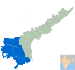
Administrative divisions
The district is divided into 3 revenue divisions viz., Chittoor, Tirupati and Madanapalle.[16] The district has 66 mandals under these 3 revenue divisions, with 2 Municipal Corporations of Chittoor and Tirupati and 6 municipalities of Madanapalle, Punganur, Palamaner, Nagari, Srikalahasti and Puttur.[17] Each revenue divisions are divided into mandals.[18] There are a total of 66 Mandals in Chittoor district.[19] There are 14 Andhra Pradesh Legislative Assembly MLA constituencies in Chittoor district.[20]
Economy
In 2006 the Indian government named Chittoor one of the country's 250 most backward districts (out of a total of 640).[21] It is one of the thirteen districts in Andhra Pradesh currently receiving funds from the Backward Regions Grant Fund Programme (BRGF).[21]
Notable people
- Chittor V. Nagaiah, film actor
- Jiddu Krishnamurti, philosopher.
- Madabhushi Ananthasayanam Ayyangar, first deputy speaker and second Speaker of Lok Sabha
- Madhurantakam Rajaram, writer, sahitya academy award winner
- Mumtaz Ali, phiosopher and educationist.
- Mohan Babu, film actor
- Nara Chandrababu Naidu, current Chief Minister of Andhra Pradesh
- N. Kiran Kumar Reddy, ex-Chief Minister of Andhra Pradesh
- P. Chinnamma Reddy, politician
- Pratap C Reddy,founder of Apollo Hospitals
- Raj Reddy, a Computer Scientist and winner of Turing Award
- Sir C.R. Reddy, educationalist, founder and vice-chancellor of Andhra University
- Dr S Venkata Mohan, a Environmental Engineer (SVUCE) and recipient of Shanti Swarup Bhatnagar (SSB) Prize, 2014
Education
Tirupati is home to multiple institutions of higher learning. Sri Venkateswara University, AP's first women's university Sri Padmavati Mahila Visvavidyalayam, Rashtriya Sanskrit Vidyapeetha are located in Tirupati. Additionally Tirupati urban area is home to several colleges and educational institutions. Kuppam houses the Dravidian University.[22] Chittoor district is home to the National Atmospheric Research Laboratory (NARL) of the Department of Space. The lab is involved in carrying out fundamental and applied research in Atmospheric and Space Sciences.
See also
- List of Hindu temples in Chittoor district
References
- ↑ "Chittoor district profile". Andhra Pradesh State Portal.
- ↑ "Census of India 2011" (PDF). http://censusindia.gov.in.
- ↑ Gazetteer of South India, Volume 1 By W. Francis.
- ↑ "The District Of Seven Hills - Tirumala".
- ↑ Srivastava, Dayawanti et al. (ed.) (2010). "States and Union Territories: Andhra Pradesh: Government". India 2010: A Reference Annual (54th ed.). New Delhi, India: Additional Director General, Publications Division, Ministry of Information and Broadcasting (India), Government of India. pp. 1111–1112. ISBN 978-81-230-1617-7.
- ↑ "Island Directory Tables: Islands by Land Area". United Nations Environment Program. 1998-02-18. Retrieved 2011-10-11.
Nordaustlandet 14,467
- ↑ 7.0 7.1 "National Informatics Center, Chittoor". Chittoor.nic.in. 2005-06-28. Retrieved 4 November 2012.
- ↑ "Chittoor district". Atmachittoor.com. Retrieved 2012-11-04.
- ↑ "Irrigation". Irrigation.cgg.gov.in. Retrieved 2012-11-04.
- ↑ 10.0 10.1 10.2 10.3 10.4 10.5 "District Census 2011". Census2011.co.in. 2011. Retrieved 2011-09-30.
- ↑ US Directorate of Intelligence. "Country Comparison:Population". Retrieved 2011-10-01.
Lebanon 4,143,101 July 2011 est.
- ↑ "2010 Resident Population Data". U. S. Census Bureau. Retrieved 2011-09-30.
Kentucky 4,339,367
- ↑ "Language in India". Language in India. Retrieved 2012-08-08.
- ↑ 14.0 14.1 14.2 "District Level Household and Facility Survey (DLHS-3), 2007-08: India. Andhra Prades" (PDF). International Institute for Population Sciences and Ministry of Health and Family Welfare. 2010. Retrieved 2011-10-03.
- ↑ "How Do I? : Obtain Marriage Certificate". National Portal Content Management Team, National Informatics Centre. 2005. Retrieved 2011-10-03.
To be eligible for marriage, the minimum age limit is 21 for males and 18 for females.
- ↑ "Industrial Profile - Chittoor District" (PDF). Commissionerate of Industries - Government of Andhra Pradesh. p. 4. Retrieved 5 November 2014.
- ↑ "Municipalities of Andhra Pradesh". C&DMA Web Site of Government of Andhra Pradesh. Commissioner & Director of Municipal Administration. Retrieved 5 November 2014.
- ↑ "District Profile". Chittoor District Official website. Retrieved 4 November 2014.
- ↑ "Mandals in Chittoor district". AP State Portal. Retrieved 24 May 2014.
- ↑ "District-wise Assembly-Constituencies in Andhra Pradesh". Ceoandhra.nic.in. Retrieved 2012-11-04.
- ↑ 21.0 21.1 Ministry of Panchayati Raj (September 8, 2009). "A Note on the Backward Regions Grant Fund Programme" (PDF). National Institute of Rural Development. Retrieved September 27, 2011.
- ↑ http://www.grotal.com/e/Dravidian-University-Kuppam-C2158
External links
| Wikimedia Commons has media related to Chittoor district. |
 |
Anantapur district | YSR district | Nellore district | |
| Chikkaballapura district, Karnataka Kolar district, Karnataka |
|
|||
| ||||
| | ||||
| Krishnagiri district, Tamil Nadu | Vellore district, Tamil Nadu | Thiruvallur district, Tamil Nadu |
| ||||||||||||||||||||||||||||||||||||||

| ||||||||||||||||||||||||||