Chitral
| Chitral چترا ل کاشکر | |
|---|---|
| State | |
 Chitral Chitral Location in Pakistan | |
| Coordinates: 35°50′46″N 71°47′09″E / 35.84611°N 71.78583°ECoordinates: 35°50′46″N 71°47′09″E / 35.84611°N 71.78583°E | |
| Country | Pakistan |
| State | Khyber Pakhtunkhwa |
| District | Chitral District |
| Established | 1969 |
| Government | |
| • Type | Municipal corporation |
| Area | |
| • Total | 14,850 km2 (5,730 sq mi) |
| Elevation | 1,100 m (3,600 ft) |
| Population (2003) | |
| • Total | 600,000 |
| Languages | |
| • Official language | Chitrali, Urdu, English |
| Time zone | PST (UTC+5) |
| Post Codes | 1720 - 0xx[1] |
| Area code(s) | +943-7 |
| Website | Official Website |
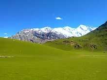
Chitral (Urdu: چترال, Khowar: چھترار also spelled as "Kashkar" or Chetrar, translated as field), is the capital of the Chitral District, situated on the western bank of the Chitral River (also called Kunar River), in Khyber Pakhtunkhwa, Pakistan. It also served as the capital of the princely state of Chitral until 1969.[2] The town is at the foot of Tirich Mir, the highest peak of the Hindu Kush, which is 25,289 ft (7,708 m) high. It has a population of 20,000. The elevation of the valley is 3,700 ft (1,100 m).
Geography and access
The easiest land access to Chitral, other than by air, is in the southwest along the Kunar Valley. However the Afghan-Pakistan border (Durand Line) and cross border tensions prevent this from being used as an internal route to the rest of the parts of Pakistan. The other routes are over high mountain passes. To the south, the 3,200 metres (10,500 ft) Lowari Pass leads 365 kilometres (227 mi) to Peshawar. In the north, the easiest route during summer runs over the 3,798 metres (12,461 ft) Broghol pass. To the east, there is a 405 kilometres (252 mi) route to Gilgit over the 3,719 metres (12,201 ft) Shandur Pass. The territory is cut off by snow from the rest of the country for up to six months a year, a problem soon to be relieved by the completion of the Lowari Tunnel.
History
Nothing definitive is recorded about the town’s first settlers. In the 3rd century AD, Kanishka, the Buddhist ruler of the Kushan empire, occupied Chitral. In the 4th century AD, the Chinese overran the valley. Raees rule over Chitral began in 1320 and came to an end in the 15th century. From 1571 onwards Chitral was the capital of the princely state of Chitral.[3]
Climate
In contrast to more southerly areas of Khyber Pakhtunkhwa, the town of Chitral has a dry Mediterranean climate (Köppen Csa) with almost no rainfall during summers. Precipitation occurs mainly from spring thunderstorms brought about by western frontal systems. In the winter the night time temperature occasionally drops to −10 C. Winter snowfall in the town can be quite heavy with an accumulation of up to two feet being quite common, at higher elevations snowfall can reach as high as 20 metres (70 ft).The weather is very cold during the winter .
| Climate data for Chitral | |||||||||||||
|---|---|---|---|---|---|---|---|---|---|---|---|---|---|
| Month | Jan | Feb | Mar | Apr | May | Jun | Jul | Aug | Sep | Oct | Nov | Dec | Year |
| Record high °C (°F) | 16.9 (62.4) |
21.0 (69.8) |
28.0 (82.4) |
34.3 (93.7) |
38.3 (100.9) |
42.5 (108.5) |
44.4 (111.9) |
42.2 (108) |
39.8 (103.6) |
34.4 (93.9) |
27.0 (80.6) |
20.7 (69.3) |
44.4 (111.9) |
| Average high °C (°F) | 8.8 (47.8) |
9.9 (49.8) |
15.1 (59.2) |
22.5 (72.5) |
28.2 (82.8) |
34.4 (93.9) |
35.9 (96.6) |
34.4 (93.9) |
31.1 (88) |
25.1 (77.2) |
18.7 (65.7) |
11.6 (52.9) |
23.0 (73.4) |
| Daily mean °C (°F) | 4.1 (39.4) |
5.3 (41.5) |
9.6 (49.3) |
15.5 (59.9) |
20.3 (68.5) |
26.1 (79) |
28.0 (82.4) |
26.5 (79.7) |
22.1 (71.8) |
16.2 (61.2) |
10.8 (51.4) |
5.9 (42.6) |
15.9 (60.6) |
| Average low °C (°F) | −0.6 (30.9) |
0.6 (33.1) |
4.2 (39.6) |
8.5 (47.3) |
12.5 (54.5) |
17.8 (64) |
20.2 (68.4) |
18.7 (65.7) |
13.1 (55.6) |
7.2 (45) |
2.9 (37.2) |
0.2 (32.4) |
8.8 (47.8) |
| Record low °C (°F) | −11.0 (12.2) |
−11.0 (12.2) |
−3.7 (25.3) |
0.0 (32) |
4.4 (39.9) |
8.9 (48) |
11.1 (52) |
10.6 (51.1) |
5.6 (42.1) |
1.1 (34) |
−3.0 (26.6) |
−12.2 (10) |
−12.2 (10) |
| Average precipitation mm (inches) | 38.4 (1.512) |
63.8 (2.512) |
97.3 (3.831) |
71.7 (2.823) |
43.9 (1.728) |
5.1 (0.201) |
4.9 (0.193) |
8.0 (0.315) |
7.3 (0.287) |
15.6 (0.614) |
20.4 (0.803) |
38.5 (1.516) |
414.9 (16.335) |
| Mean monthly sunshine hours | 134.0 | 133.7 | 150.4 | 188.6 | 247.0 | 286.3 | 285.4 | 258.6 | 231.0 | 214.0 | 182.5 | 130.7 | 2,442.2 |
| Source: NOAA (1971-1990) [4] | |||||||||||||
Demographics
| Chitral growth | |||
|---|---|---|---|
| Census | Pop. | %± | |
| 1981 | 303,351 | ||
| Source: Census of Pakistan, | |||
Khowar is the most widely spoken language, while English and Urdu are understood and spoken. And has a great Chitrali influence as it was the bastion of the 52.3% of Chitral's population is in the 15–59 years age category. Around 11% of the population is under 6 years of age.
Educational institutions
- University of Chitral
- Virtuall university of pakistan
- New City College
- Chitral University Campus
- Shaheed Benazir Bhutto University
- Qutaiba Public School Chitral Denin
- Chitral Model College Chitral
- Government Technical and Vocational College, Garum Chassma Road, Chitral
- Government Degree College
- Government Girls Degree College
- University of Booni
- Government Centennial Model High School
- Government Centennial Model School for Girls
- Government College of Commerce
- Frontier Corp Public School
- Chitral Public School & College, (Chitral's first English Medium School)
- Langlands School and College, formerly known as Sayurj Public School
- Pamir Public School
- Pearl College of Education
- Orion School Of learning Booni
- Oxford School And College Booni
- Iqra Model School
- AFAQ model school and college, denin chitral
- Terichmir Model School
- Al-Nasir Community Based School, Garam Chashma
- Chamber of Commerce College, Garam Chashma
- Al-Nasir Cbs School and Degree College, Garam Chashma
- Injigan Ideal Public school, (Garam chashma)
- Model School, Warijun Mullkhow
- Govt High School for Boys, Warijun Mullkhow
- Drosh Public School, Drosh
- Muslim Model School, Jughoor
- Jinnah Public School, Drosh
- Broze Public School & College, Broze Chitral
- Broze Model College For Girls, Broze Chitral
- Seen public school
- Oriental Model School, Booni
- Oriental Model College, Booni
- Frontier Corps Public Schools and Colleges (FCPS&C)
- Govt High School Koghuzi, Chitral
- Govt High School Kuju, Chitral
Administration
Chitral is represented in the National Assembly[5] and Provincial Assembly by one elected MNA and two elected MPAs.[6]
Population
As of July 2014, the Chitral population is above one million.
Sport
Unlike the rest of Pakistan where cricket dominates, polo and soccer are more popular in Chitral. A number of sport festivals and tournaments are held throughout the year. Chitral has also produced some national players such as Muhammad Rasool who plays for the national football team.
Newspapers
A few number of newspapers are published by Chitral Press
- Chitral Today
- Chitral Times
- Chitral News
- Awaaz-e-Chitral
- The Kalash Times
- Chitral Vision
- Weekly Chitral
Notes
- ↑ "Post Codes". Pakistan Post Office. Retrieved 17 March 2015.
- ↑ Gupta, Om. Town location&hl=en&sa=X&ei=ajdrUqqdGbCB7QbZn4DYAw&ved=0CDcQ6AEwAzgK#v=onepage&q=Chitral%20Town%20location&f=false Encyclopaedia of India, Pakistan and Bangladesh.
- ↑ "Chitral, a Study in Statecraft". IUCN.
- ↑ "Chitral Climate Normals 1971-1990". National Oceanic and Atmospheric Administration. Retrieved January 16, 2013.
- ↑ http://www2.ecp.gov.pk/vsite/ElectionResult/AllResults.aspx?assemblyid=NA
- ↑ Constituencies and MPAs - Website of the Provincial Assembly of the NWFP
References
- Decker, D. Kendall (1992). Languages of Chitral.
- Durand, Col. A. (1899). The Making of a frontier.
- Leitner, G. W. (1978). Dardistan in 1866, 1886 and 1893: Being An Account of the History, Religions, Customs, Legends, Fables and Songs of Gilgit, Chilas, Kandia (Gabrial) Yasin, Chitral, Hunza, Nagyr and other parts of the Hindukush, as also a supplement to the second edition of The Hunza and Nagyr Handbook. And An Epitome of Part III of the author’s The Languages and Races of Dardistan (First reprint ed.). New Delhi: Manjusri Publishing House. Check date values in:
|year= / |date= mismatch(help)
External links
| Wikivoyage has a travel guide for Chitral. |
| Wikimedia Commons has media related to Chitral. |