Chirat-l'Église
| Chirat-l'Église | |
|---|---|
|
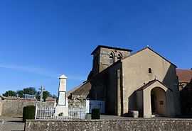
The church in Chirat-l'Eglise | |
 Chirat-l'Église | |
|
Location within Auvergne region  Chirat-l'Église | |
| Coordinates: 46°14′38″N 3°02′07″E / 46.2439°N 3.0353°ECoordinates: 46°14′38″N 3°02′07″E / 46.2439°N 3.0353°E | |
| Country | France |
| Region | Auvergne |
| Department | Allier |
| Arrondissement | Montluçon |
| Canton | Ébreuil |
| Intercommunality | Sioule, Colettes et Bouble |
| Government | |
| • Mayor (2008–2014) | André Theveniot |
| Area1 | 18.48 km2 (7.14 sq mi) |
| Population (2008)2 | 136 |
| • Density | 7.4/km2 (19/sq mi) |
| INSEE/Postal code | 03077 / 03330 |
| Elevation |
311–494 m (1,020–1,621 ft) (avg. 450 m or 1,480 ft) |
|
1 French Land Register data, which excludes lakes, ponds, glaciers > 1 km² (0.386 sq mi or 247 acres) and river estuaries. 2 Population without double counting: residents of multiple communes (e.g., students and military personnel) only counted once. | |
Chirat-l'Église is a commune in the Allier department in Auvergne in central France.
Geography
The river Bouble forms all of the commune's northwestern border and most of its northeastern border.
Population
| Historical population | ||
|---|---|---|
| Year | Pop. | ±% |
| 1962 | 175 | — |
| 1968 | 221 | +26.3% |
| 1975 | 162 | −26.7% |
| 1982 | 166 | +2.5% |
| 1990 | 129 | −22.3% |
| 1999 | 119 | −7.8% |
| 2008 | 136 | +14.3% |
See also
References
| Wikimedia Commons has media related to Chirat-l'Église. |