Chios
| Chios Χίος | |
|---|---|
 | |
 Chios | |
|
Location within the region  | |
| Coordinates: 38°24′N 26°01′E / 38.400°N 26.017°ECoordinates: 38°24′N 26°01′E / 38.400°N 26.017°E | |
| Country | Greece |
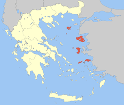
| Administrative region | North Aegean |
| Regional unit | Chios |
| Area | |
| • Municipality | 842.5 km2 (325.3 sq mi) |
| Highest elevation | 1,297 m (4,255 ft) |
| Lowest elevation | 0 m (0 ft) |
| Population (2011)[1] | |
| • Municipality | 51,930 |
| • Municipality density | 62/km2 (160/sq mi) |
| Time zone | EET (UTC+2) |
| • Summer (DST) | EEST (UTC+3) |
| Postal code | 82x xx |
| Area code(s) | 227x0 |
| Vehicle registration | ΧΙ |
| Website | www.chios.gr |
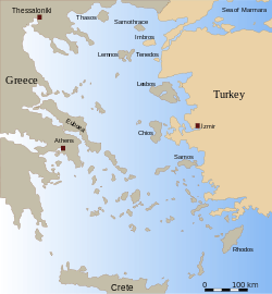
Chios (/ˈkaɪ.ɒs/; Greek: Χίος, pronounced [ˈçios]; Turkish: sakız alternative transliterations Khíos and Híos) is the fifth largest of the Greek islands, situated in the Aegean Sea, 7 kilometres (4.3 mi) off the Anatolian coast. The island is separated from Turkey by the Chios Strait. Chios is notable for its exports of mastic gum and its nickname is The mastic island. Tourist attractions include its medieval villages and the 11th-century monastery of Nea Moni, a UNESCO World Heritage Site.
Administratively, the island forms a separate municipality within the Chios regional unit, which is part of the North Aegean region. The principal town of the island and seat of the municipality is Chios town.[2] Locals refer to Chios town as "Chora" ("Χώρα" literally means land or country, but usually refers to the capital or a settlement at the highest point of a Greek island).
Geography
Chios island is crescent or kidney shaped, 50 kilometres (31 mi) long from north to south, 29 kilometres (18 mi) at its widest, and covers an area of 842 square kilometres (325 sq mi). The terrain is mountainous and arid, with a ridge of mountains running the length of the island. The two largest of these mountains, "Pelineon" (1,297 metres (4,255 ft)) and "Epos" (1,188 metres (3,898 ft)), are situated in the north of the island. The center of the island is divided between east and west by a range of smaller peaks, known as "Provatas".
Regions
Chios can be divided into five regions:
East coast

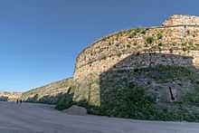
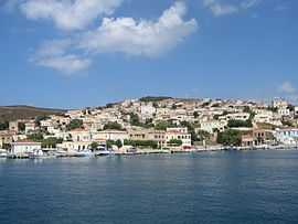
Midway up the east coast lie the main population centers, the main town of Chios, and the regions of Vrontados and Kambos. Chios Town, with a population of 32,400, is built around the island's main harbour and medieval castle. The current castle, with a perimeter of 1,400 metres (4,600 ft), was principally constructed during the time of Venetian and Ottoman rule, although remains have been found dating settlements there back to 2000 B.C. The town was substantially damaged by an earthquake in 1881, and only partially retains its original character.
North of Chios Town lies the large suburb of Vrontados (population 4,500), which claims to be the birthplace of Homer.[3] The suburb lies in the Omiroupoli municipality, and its connection to the poet is supported by an archaeological site known traditionally as "Teacher's Rock".[4]
Directly south of Chios Town lies the island's airport and the region of Kambos (Κάμπος, "plain"), a large fertile plain. Here there are stone mansions and walled orchards. At the southern edge of the Kambos plain lies the town of Thymiana.[5] Thymiana is the sole source of a beige-burgundy two-tone sandstone used both in the local mansions and much of the town itself. Inland lie a number of villages rising up into the central mountains culminating with the village of Ayios Georgios Sykoussis, perched at the peak dividing east from west. Along the coast lies Karfas (Καρφάς), a sandy beach, which along with the nearby village of Ayia Ermioni (Άγια Ερμιόνη) is now the main tourist centre, with a number of large and small hotels.
Southern region (Mastichochoria)


In the south of the island are the Mastichochoria,[6] literally: Mastic Villages, the seven villages of Mesta (Μεστά), Pyrgi (Πυργί), Olympi (Ολύμποι), Kalamoti (Καλαμωτń), Vessa (Βέσσα), Lithi (Λιθί) and Elata (Ελάτα), which together have controlled the production of mastic gum in the area since the Roman period. The villages, built between the 14th and 16th centuries, have a carefully designed layout with fortified gates and narrow streets to protect against the frequent raids by marauding pirates. Between Chios Town and the Mastichochoria lie a large number of historic villages including Armolia (Αρμόλια), Myrmighi (Μυρμήγκι), and Kalimassia (Καλλιμασιά). Along the east coast are the fishing villages of Kataraktis (Καταρράκτης) and to the south Nenita (Νένητα).
The south coast has two populated areas; the bay of Komi and the ancient village of "Emporio", inhabited since 1800 BC, and the site of the black volcanic beach of "Mavra Volia", believed to have been created by the explosion of Santorini island in 1600 BC.
West coast
The west coast, between the deep natural harbour of Limenas at the south and the town of Vollisos in the north, forms a crescent shaped series of almost uninhabited rocky bays. The nearest population centres are the two hillside villages of Lithi and Sidirounta, while further inland lie the villages of Elata, Vessa, Agio Giorgi, Avgonyma and the deserted village of Anavatos. There is a system of stone beacons that were built at regular intervals to signal the approach of ships, and warning the islanders against invasions by pirates.
Northern region
The north of the island contains two villages: Volissos on the west coast, and Kardamyla on the east. Further to the north, are three villages where cherries are grown—Amades, Viki and Kambia. In June Kambia holds an annual Cherry Festival—"Yiortí ton Kerrasión". Kambia holds several festivals during the summer months. Also located in the northern region is the island's tallest mountain, Mount Pelineon, at 1,297 metres (4,255 feet).
Spartounda and Fyta lie a few miles from Kambia. In the village of Fyta stands a watchtower dating back to the late 16th century, the time of the Genoese occupation.
The village of Kourounia lies 20 kilometres (12 mi) north of Volissos in the northwestern part of the island. Next to Kourounia is the village of Egrigoros.
Interior
Directly in the centre of the island, between the villages of Avgonyma to the west and Karyes to the east, is the 11th century monastery of Nea Moni, a UNESCO World Heritage Site. The monastery was built with funds given by the Byzantine Emperor Constantine IX, after three monks, living in caves nearby, had petitioned him while he was in exile on the island of Mytilene. The monastery had substantial estates attached, with a thriving community until the massacre of 1822. It was further damaged during the 1881 earthquake.[7] In 1952, due to the shortage of monks, Nea Moni was converted to a convent.
Further south is the region of Kambochoria. This is a collection of medieval villages (Halkios, Vavili, Vassileoniko, Ververato, Dafnonas, and Zifias) with a combined population of about 3,000 and an agricultural economy. In this region four varieties of wild tulips grow.
West of the Kambochoria on the central ridge of the island lies the 16th century village of Agios Geórgios Sikousis. The village is situated 400 metres (1,300 ft) above sea level, strategically overlooking both sides of the island, and was previously fortified with both a wall and a tower.
Geology

The Chios Basin is a hydrographic sub-unit of the Aegean Sea adjacent to the island of Chios.[8]
Climate
The island's climate is warm and moderate, categorised as Temperate, Mediterranean(Csa), with modest variation due to the stabilising effect of the surrounding sea. Average temperatures normally range from a summer high of 27 °C (81 °F) to a winter low of 11 °C (52 °F) in January, although temperatures of over 40 °C (104 °F) or below freezing can sometimes be encountered.
Rainfall while usually plentiful, varies greatly both throughout the year and between years. Rain is rare during the summer months, but the winters are changeable and wet. Sunshine is plentiful, as is typical of the Eastern Mediterranean, with almost no cloud cover in the summer months. Average humidity varies from 75% in winter to 60% in summer.
The island normally experiences steady breezes (average 3–5 m/s) throughout the year, with winds direction predominantly northerly ("Etesian" Wind—locally called the "Meltemi"), or south westerly (Sirocco).
| Climate data for Chios, Greece | |||||||||||||
|---|---|---|---|---|---|---|---|---|---|---|---|---|---|
| Month | Jan | Feb | Mar | Apr | May | Jun | Jul | Aug | Sep | Oct | Nov | Dec | Year |
| Average high °C (°F) | 11 (52) |
11 (52) |
13 (55) |
17 (63) |
22 (72) |
26 (79) |
28 (82) |
28 (82) |
25 (77) |
20 (68) |
16 (61) |
13 (55) |
19.2 (66.5) |
| Average low °C (°F) | 5 (41) |
5 (41) |
6 (43) |
9 (48) |
13 (55) |
17 (63) |
19 (66) |
19 (66) |
16 (61) |
12 (54) |
9 (48) |
6 (43) |
11.3 (52.4) |
| Average precipitation mm (inches) | 100 (3.94) |
78 (3.07) |
61 (2.4) |
44 (1.73) |
24 (0.94) |
4 (0.16) |
1 (0.04) |
0 (0) |
8 (0.31) |
23 (0.91) |
55 (2.17) |
122 (4.8) |
520 (20.47) |
| Source: www.weather-to-travel.com[9] | |||||||||||||
History

Etymology
Known as "Ophioussa" (Οφιούσσα, "snake island") and "Pityoussa" (Πιτυούσσα, "pine-tree island") in Antiquity, during the later Middle Ages the island was ruled by a number of non-Greek powers and was known as Scio (Genoese), Chio (Italian) and Sakız (صاقيز —Ottoman Turkish). The capital during that time was "Kastron" (Κάστρον, "castle").
Prehistoric period
Archaeological research on Chios has found evidence of habitation dating back at least to the Neolithic era. The primary sites of research for this period have been cave dwellings at Hagio(n) Galas, in the north, and a settlement and accompanying necropolis in modern-day Emporeio at the far south of the island. Scholars lack information on this period. The size and duration of these settlements have therefore not been well-established.
The British School at Athens excavated the Emporeio site in 1952–1955, and most current information comes from these digs.[10] The Greek Archaeological Service has also been excavating periodically on Chios since 1970, though much of its work on the island remains unpublished.
The noticeable uniformity in the size of houses at Emporeio leads some scholars to believe that there may have been little social distinction during the Neolithic era on the island. The inhabitants apparently all benefited from agricultural and livestock farming.[11]
It is also widely held by scholars that the island was not occupied by humans during the Middle Bronze Age (2300–1600), though researchers have recently suggested that the lack of evidence from this period may only demonstrate the lack of excavations on Chios and the northern Aegean.[12]
By at least the 11th century BC the island was ruled by a monarchy, and the subsequent transition to aristocratic (or possibly tyrannic) rule occurred sometime over the next four centuries. Future excavations may reveal more information about this period.[13] 9th-century Euboean and Cypriote presence on the island is attested by ceramics, while a Phoenician presence is noted at Erythrae, the traditional competitor of Chios on the mainland.[14]
Archaic and Classical periods
Pherecydes, native to the Aegean, wrote that the island was occupied by the Leleges,[15] aboriginal Greeks themselves reported to be subject to the Minoans on Crete.[16] They were eventually driven out by invading Ionians.
Chios was one of the original twelve member states of the Ionian League. As a result, Chios, at the end of the 7th century BC,[17] was one of the first cities to strike or mint coins, establishing the sphinx as its specific symbol. It maintained this tradition for almost 900 years.
In the 6th century BC Chios’ government adopted a constitution similar to that developed by Solon in Athens[18] and later developed democratic elements with a voting assembly and people’s magistrates called damarchoi.[19]
In 546 BC Chios became subject to the Persian Empire.[19] Chios joined the Ionian Revolt against the Persians in 499 BC. The naval power of Chios during this period is demonstrated by the fact that the Chians had the largest fleet (100 ships) of all the Ionians at the Battle of Lade in 494 BC. At Lade the Chian fleet continued doggedly fighting the Persian fleet even after the defection of the Samians and others but ultimately the Chians were forced to retreat and were again subject to Persian domination.[20]
The defeat of Persia at the Battle of Mycale in 479 BC meant the liberation of Chios from Persian rule. When the Athenians formed the Delian League Chios joined as one of the few members who did not have to pay tribute but instead supplied ships to the alliance.[21]
By the fifth to 4th centuries BC, the island had grown to an estimated population of over 120,000 (two to three times the estimated population in 2005), based on the huge necropolis at the main city of Chios. It is thought that the majority of the population lived in that area.[22]
In 412 BC during the Peloponnesian War Chios revolted against Athens and the Athenians besieged it. Relief only came the following year when the Spartans were able to raise the siege. In the 4th century BC Chios was a member of the Second Athenian Empire but revolted against Athens during the Social War (357–355 BC), and Chios became independent again until the rise of Macedonia.
Hellenistic period

In the decades immediately preceding Macedonia's domination of the Greek city-states, Chios was home to a school of rhetoric which Isocrates had founded,[23] as well as a faction aligned with Sparta. After the Battle of Leuctra, supporters of the Lacedaemonians were exiled. Among the exiled were Damasistratus and his son Theopompus, who had received instruction from the school and went on to study with Isocrates in Athens before becoming a historian.
Theopompus moved back to Chios with the other exiles in 333 BC after Alexander had invaded Asia Minor and decreed their return,[24] as well as the exile or trial of Persian supporters on the island. Theopompus was exiled again sometime after Alexander's death and took refuge in Egypt.[25]
During this period, the island also had become the largest exporter of Greek wine, which was noted for being of relatively high quality (see "Chian wine"). Chian amphoras, with a characteristic sphinx emblem and bunches of grape have been found in nearly every country that the ancient Greeks traded with from as far away as Gaul, Upper Egypt and Southern Russia.[26]
Roman period
During the Third Macedonian War, thirty-five vessels allied to Rome, carrying about 1,000 Galatian troops, as well as a number of horses, were sent by Eumenes II to his brother Attalus.
Leaving from Elaea, they were headed to the harbour of Phanae, planning to disembark from there to Macedonia. However, Perseus's naval commander Antenor intercepted the fleet between Erythrae (on the Western coast of Turkey) and Chios.
According to Livy,[27] they were caught completely off-guard by Antenor. Eumenes' officers at first thought the intercepting fleet were friendly Romans, but scattered upon realizing they were facing an attack by their Macedonian enemy, some choosing to abandon ship and swim to Erythrae. Others, crashing their ships into land on Chios, fled toward the city.
The Chians however closed their gates, startled at the calamity. And the Macedonians, who had docked closer to the city anyway, cut the rest of the fleet off outside the city gates, and on the road leading to the city. Of the 1,000 men, 800 were killed, 200 taken prisoner.'
After the Roman conquest Chios became part of the province of Asia.
Pliny remarks upon the islanders' use of variegated marble in their buildings, and their appreciation for such stone above murals or other forms of artificial decoration.[28]
Byzantine period

After the permanent division of the Roman Empire in 395 AD, Chios was for six centuries part of the Byzantine Empire. This came to an end when the island was briefly held (1090–97) by Tzachas, a Turkish bey in the region of Smyrna during the first expansion of the Turks to the Aegean coast.[29] However, the Turks were driven back from the Aegean coast by the Byzantines aided by the First Crusade, and the island was restored to Byzantine rule by admiral Constantine Dalassenos.
This relative stability was ended by the sacking of Constantinople by the Fourth Crusade (1204) and during the turmoil of the 13th century the island's ownership was constantly affected by the regional power struggles. After the Fourth Crusade, the Byzantine empire was divided up by the Latin emperors of Constantinople, with Chios nominally becoming a possession of the Republic of Venice. However, defeats for the Latin empire resulted in the island reverting to Byzantine rule in 1225.
Genoese period (1304–1566)


The Byzantine rulers had little influence and through the Treaty of Nymphaeum, authority was ceded to the Republic of Genoa (1261).[30] At this time the island was frequently attacked by pirates, and by 1302–1303 was a target for the renewed Turkish fleets. To prevent Turkish expansion, the island was reconquered and kept as a renewable concession, at the behest of the Byzantine emperor Andronicus II Palaeologus, by the Genovese Benedetto I Zaccaria (1304), then admiral to Philip of France. Zaccaria installed himself as ruler of the island, founding the short-lived Lordship of Chios. His rule was benign and effective control remained in the hands of the local Greek landowners. Benedetto Zacharia was followed by his son Paleologo and then his grandsons or nephews Benedetto II and Martino. They attempted to turn the island towards the Latin and Papal powers, and away from the predominant Byzantine influence. The locals, still loyal to the Byzantine Empire, responded to a letter from the emperor and, despite a standing army of a thousand infantrymen, a hundred cavalrymen and two galleys, expelled the Zacharia family from the island (1329) and dissolved the fiefdom.[31]
Local rule was brief. In 1346, a chartered company or Maona (the "Maona di Chio e di Focea") was set up in Genoa to reconquer and exploit Chios and the neighbouring town of Phocaea in Asia Minor. Although the islanders firmly rejected an initial offer of protection, the island was invaded by a Genoese fleet, led by Simone Vignoso, and the castle besieged. Again rule was transferred peacefully, as on 12 September the castle was surrendered and a treaty signed with no loss of privileges to the local landowners as long as the new authority was accepted.
The Genoese, being interested in profit rather than conquest, controlled the trade-posts and warehouses, in particular the trade of mastic, alum, salt and pitch. Other trades such as grain, wine oil and cloth and most professions were run jointly with the locals. After a failed uprising in 1347, and being heavily outnumbered (less than 10% of the population in 1395), the Latins maintained light control over the local population, remaining largely in the town and allowing full religious freedom. In this way the island remained under Genoese control for two centuries. By 1566, when Genoa lost Chios to the Ottoman Empire, there were 12.000 Greeks and 2.500 Genoese (or 17% of the total population) in the island.[32]
By the early 15th century, Asia Minor and the surrounding islands had fallen under Ottoman rule, but the Genoese families managed to maintain control over the island through the payment of a tribute to the Sultan. By the 16th century, as Genoese power waned, trade with Genoa had decreased and the local rulers become assimilated into the local population.
This largely independent rule of Genoese families continued until 1566, when, with tensions rising, the Sultan decided that the island could potentially be used as a base for Western attacks on Constantinople. The island was invaded by Ottoman troops and absorbed into the Ottoman Empire. Consequently, Greek Phanariotes gradually replaced these Genoese families as a protectorate of Chios and maintained relative autonomy despite the Ottoman occupation.
Ottoman period
During Ottoman rule, the government and tax gathering again remained in the hands of Greeks and the Turkish garrison was small and inconspicuous.[33]
As well as the Latin and Turkish influx, documents record a small Jewish population from at least 1049 AD.[34] The original Greek (Romaniote) Jews, thought to have been brought over by the Romans, were later joined by Sephardic Jews welcomed by the Ottomans during the Iberian expulsions of the 15th century.
The mainstay of the island's famous wealth was the mastic crop. Chios was able to make a substantial contribution to the imperial treasury while at the same time maintaining only a light level of taxation. The Ottoman government regarded it as one of the most valuable provinces of the Empire.[35]
Modern period
When the Greek War of Independence broke out, the island's leaders were reluctant to join the revolutionaries, fearing the loss of their security and prosperity. However, in March 1822, several hundred armed Greeks from the neighbouring island of Samos landed in Chios. They proclaimed the Revolution and launched attacks against the Turks, at which point islanders decided to join the struggle.
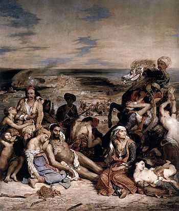
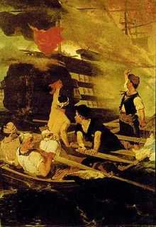
Ottomans landed a large force on the island consequently and put down the rebellion. The Ottoman massacre of Chios expelled, killed, or enslaved the inhabitants of the island.[36] It wiped out whole villages, and affected the Mastichochoria area, the mastic growing villages in the south of the island. It triggered negative public reaction in Western Europe, as portrayed by Eugène Delacroix, and in the writing of Lord Byron and Victor Hugo.
In 1881, an earthquake, estimated as 6.5 on the moment magnitude scale, damaged a large portion of the island's buildings and resulted in great loss of life. Reports of the time spoke of 5,500–10,000 fatalities.[37]
Chios rejoined the rest of independent Greece after the First Balkan War (1912). The Greek Navy liberated Chios in November 1912 in a hard fought but brief amphibious operation. Turkey recognized Greece's annexation of Chios and the other Aegean islands by the Treaty of London (1913).
It was affected by the population exchanges after the Greco–Turkish War of 1919–1922, the incoming Greek refugees settling in Kastro (previously Turkish) and in new settlements hurriedly built south of Chios Town.
During World War II, the island was occupied by Nazi Germany (1941–44), resulting in deprivation for the inhabitants. The larger part of the Jewish population had left earlier in the century, but as in all Nazi-occupied territories, the Jewish community was hunted down for arrest and trans-shipping to concentration camps for extermination. In 1943, the local government warned the Jewish population of the island that the Gestapo had orders to arrest them all and take them to Germany. Some families heeded the warning and were smuggled off the island. Others were protected by the local Greek villages, particularly in the southern towns with high elevation; i.e.: Tholopotami, St Georgios and Kalamoti. Local Greeks risked high penalties to protect Jewish inhabitants. The remainder were taken by the Gestapo and nothing more is known of their fate; they are assumed to have perished in one of the Nazi extermination camps.
The island saw some local violence during the Greek Civil War setting neighbour against neighbour. This ended when the final band of communist fighters was trapped and killed in the orchards of Kambos and their bodies driven through the main town on the back of a truck. In March 1948, the island was used as an internment camp for female political detainees (communists or relatives of guerillas) and their children, who were housed in military barracks near the town of Chios. Up to 1300 women and 50 children were housed in cramped and degrading conditions, until March 1949 when the camp was closed and the inhabitants moved to Trikeri.[38]
The production of mastic was threatened by the Chios forest fire that swept the southern half of the island in August 2012 and destroyed some mastic groves.
Demographics
According to the 2011 census, Chios has a permanent resident population of 52,674.[39]
According to the Greek Embassy in America, there are about 20,000 Chians in United States today.
Government
The present municipality Chios was formed at the 2011 local government reform by the merger of the following 8 former municipalities, that became municipal units:[2]
Economy

Commerce
The local merchant shipping community transports several locally grown products including mastic, olives, figs, wine, mandarins, and cherries.
Cuisine
Local specialities of the island include:
- Kordelia
- Malathropita
- Sfougato
- Mamoulia (dessert)
- Masourakia (dessert)
- Mastichato (drink)
Culture


- Nea Moni is a monastery with fine mosaics from Constantine IX's reign and a World Heritage Site.[40]
- There is reportedly a "small country church" on Chios that has a family memorial which lists 14 generations of a family, starting at the fifth century BC and going back to the tenth century BC, before there were any written records in Greece.[41]
- Forts
- Castle of Chios, a Byzantine fort built in the 10th century
- St. George's church
- Museums
- Traditions
- The town of Vrontados is home to a unique Easter celebration, where competing teams of locals gather at the town's two (rival) churches to fire tens of thousands of homemade rockets at the other church's bell tower while the Easter service is going on inside the churches, in what has become known as rouketopolemos.
- Sports
- F.C. Lailapas (Chios town)
International relations
Twin towns – Sister cities
Chios is twinned with:
 Brezno, Slovakia
.svg.png) Dinant, Belgium
Dinant, Belgium Ermoupoli, Greece
 Genoa, Italy (since 1985)[42]
 Guiyang, China
- Ortona, Italy
- Polykastro, Greece
Notable natives and inhabitants
A native of Chios is known in English as a Chian.[43]
Ancient

- Homer (8th century BC), poet
- Glaucus of Chios (7th–6th century BC), early welder; credited by Herodotus with inventing "the art of welding" (Histories, 1.25)
- Archermus (6th century BC), sculptor
- Athenis (6th century BC), sculptor
- Bupalus (6th century BC), sculptor
- Ion of Chios (c. 490–c. 420 BC), writer of prose and poetry, historian and philosopher
- Oenopides (c. 490–c. 420 BC), mathematician and geometer
- Hippocrates of Chios (c. 470–c. 410 BC), notable mathematician, geometer and astronomer
- Theopompus of Chios (378–c. 320 BC), rhetorical historian[44]
- Erasistratus of Chios (304–250 BC), pioneering anatomist, royal physician and founder of the ancient medical school of Alexandria, who discovered the linking between organs through the systems of veins, arteries and nerves[45]
- Aristo of Chios (c. 260 BC), Stoic philosopher
- Claudia Metrodora (c. 54-68 AD), public benefactor
Medieval
- Mavrocordatos family, noble Byzantine family
- Saint Markella (14th century), was born and suffered martyrdom on Chios
- Matrona of Chios (* 15th century, † before 1455), saint of the Orthodox church
- Andrea Bianco (15th century), Genoese cartographer resided on Chios
- Some claim Chios is Christopher Columbus's birthplace.[46] Columbus himself said he was from the Republic of Genoa, which included the island of Chios at the time. Columbus was friendly with a number of Chian Genoese families, referenced Chios in his writings and used the Greek language for some of his notes.[47] 'Columbus' remains a common surname on Chios. Other common Greek spellings are: Kouloumbis and Couloumbis.
- Francisco Albo (16th century), pilot of Magellan expedition, the first circumnavigation of the Earth
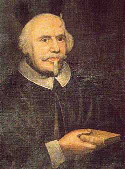
- Leo Allatius (Leone Allacci) (c. 1586–1669), Greek Catholic scholar and theologian
Modern
- Nikephoros of Chios (c.1750–1821), abbot of the monastery Nea Moni and theological writer
- Neophytos Vamvas (1770–1856), cleric and educator
- Alexandros Kontostavlos (1789–1865), politician
- Amvrosios Skaramagas (1790–1864), merchant
- George Colvocoresses (1816–1872), military officer
- Michel Emmanuel Rodocanachi (1821–1901), trader and banker of London
- Patriarch Constantine V of Constantinople (1833–?)
- Ralli Brothers (18th–19th century), founders of major 19th century trading enterprise
- Ibrahim Edhem Pasha (1819–1893), Ottoman Grand Vizier
- Namık Kemal (1840–1888), one of the principal founders of modern Turkish literature, served as a sub-prefect (exiled in practical terms) of Chios from 1886 to his death on the island in 1888
- Osman Hamdi Bey (1842–1910), Ottoman painter, archaeologist
- George I. Zolotas (1845–1906), local historian of the island and director of the high school of Chios; wrote a five volume History of Chios in Greek language
- Ioannis Psycharis (1854–1929), philologist, descented from Chios
- Konstantinos Amantos (1874–1960), Byzantine scholar, professor at the University of Athens, member of the Athens Academy
- Stavros Livanos (1891–1963), shipping magnate
- Philip Pandely Argenti (1891–1974), member of an old Chian aristocratic family, greatest historian of the island, wrote more than a dozen historical portrayals of the island of Chios
- Kostia Vlastos (1883-1967), banker
- Ioannis Despotopoulos (1903–1992), architect
- Kostas Perrikos (1905–1943), Greek Resistance figure, leader of PEAN
- Adamantios Lemos (1916-2006), actor
- Andreas Papandreou (1919–1996), politician, Prime Minister of Greece
- Patriarch Diodoros of Jerusalem (1923-2000), Patriarch of Jerusalem 1981–2000
- Mikis Theodorakis (1925), composer
- Jani Christou (1926–1970), composer
- Stamatios Krimigis (1938), NASA space scientist
- Takis Fotopoulos (1940), political writer
- Adamantios Vassilakis (1942), diplomat
- Dimitris Varos (1949), author, poet, journalist
- Mark Palios (1952, of Chian descent), former professional footballer and former chief executive of the English Football Association
- Matthew Mirones (1956), New York politician
- John Sitaras (1972), fitness professional
See also
References
- ↑ "Detailed census results 2011" (in Greek).
- ↑ 2.0 2.1 Kallikratis law Greece Ministry of Interior (Greek)
- ↑ John Boardman; C. E. Vaphopoulou-Richardson (1986). Chios: a conference at the Homereion in Chios, 1984. Clarendon Press. p. v. ISBN 9780198148647. Retrieved 30 July 2014.
- ↑ Δασκαλóπετρα
- ↑ Θυμιανά
- ↑ Μαστιχοχώρια
- ↑ 1881 Earthquake
- ↑ C.Michael Hogan. 2011. Aegean Sea. Eds. P.Saundry & C.J.Cleveland. Encyclopedia of Earth. National Council for Science and the Environment. Washington DC
- ↑ "Chios". July 2011. Retrieved 6 February 2009.
- ↑ Boardman, John Excavations in Chios, 1952–1955: Greek Emporio (London : British School of Archaeology at Athens; Thames and Hudson, 1967), cf. also Hood, Sinclair Excavations in Chios, 1938–1955: prehistoric Emporio and Ayio Gala (London : British School of Archaeology at Athens: Thames and Hudson, 1981–) ISBN 0-500-96017-8
- ↑ Merouses, Nikos Chios. Physiko periballon & katoikese apo te neolithike epoche mechri to telos tes archaiothtas. (Chios. Natural Environment & Habitation from the Neolithic Age to the end of Antiquity) pg. 80. Papyros, 2002
- ↑ Merouses 2002 ch. 4
- ↑ Merouses 2002 ch. 5, sect. 1
- ↑ I.S. Lemos, The Protogeometric Aegean 2002:240, and Euboean ceramics in the Archeological Museum, noted by Robin Lane Fox, Travelling Heroes in the Epic Age of Homer, 2008:60 note 59.
- ↑ Strabo 14.1.3
- ↑ Herodotus 1.171
- ↑ Agelarakis A., "Analyses of Cremated Human Skeletal Remains Dating to the Seventh Century BC, Chios, Greece". Horos: Ena Archaeognostiko Periodiko 4 (1986): 145–153.
- ↑ Murray, Oswyn (1993). Early Greece (2nd ed. ed.). London: Fontana. p. 188. ISBN 0006862497.
- ↑ 19.0 19.1 Grant, Michael (1989). The Classical Greeks. Guild Publishing London. p.149
- ↑ Herodotus, The Histories IV.15
- ↑ Thucydides, Peloponnesian War 3.10.
- ↑ Merouses 2002 ch. 5, sect. 3
- ↑ Cicero, De Oratore, 2, 13.22
- ↑ A translation of the decree can be viewed online
- ↑ Anthon, Charles A Manual of Greek Literature, p.251, 1853
- ↑ Hugh Johnson, Vintage: The Story of Wine pg 41. Simon and Schuster 1989
- ↑ Livy, 44.28
- ↑ "Pliny the Elder, The Natural History, BOOK XXXVI. THE NATURAL HISTORY OF STONES., CHAP. 5. (6.)—AT WHAT PERIOD MARBLE WAS FIRST USED IN BUILDINGS". Perseus.tufts.edu. Retrieved 2013-03-26.
- ↑ Brownworth, Lars (2009) Lost to the West: The Forgotten Byzantine Empire That Rescued Western Civilization, Crown Publishers, ISBN 978-0-307-40795-5: "...the Muslims captured Ephesus in 1090 and spread out to the Greek islands. Chios, Rhodes, and Lesbos fell in quick succession." p. 233.
- ↑ William Miller, "The Zaccaria of Phocaea and Chios. (1275–1329.)" The Journal of Hellenic Studies, Vol. 31, 1911 (1911), pp. 42–55; doi:10.2307/624735.
- ↑ Arbel, Benjamin, Bernard Hamilton, and David Jacob. Latins and Greeks in the Eastern Mediterranean After 1204. ISBN 0-7146-3372-0.
- ↑ Chios History
- ↑ William St. Clair, That Greece Might Still Be Free, The Philhellenes in the War of Independence, Oxford University Press, London, 1972, p.79. ISBN 0-19-215194-0.
- ↑ "The Sephardic Community of Chios". Sephardicstudies.org. Retrieved 22 March 2009.
- ↑ William St. Clair, p. 79
- ↑ Hellenic Genocide Events retrieved 19 May 2008
- ↑ Y. Altinok; B. Alpar B; N. Özer; C. Gazioglu (2005). "1881 and 1949 earthquakes at the Chios-Cesme Strait (Aegean Sea) and their relation to tsunamis" (PDF). Natural Hazards and Earth System Sciences 5: 717–725. doi:10.5194/nhess-5-717-2005. Retrieved 31 July 2010.
- ↑ Becoming a Subject: Political Prisoners During the Greek Civil War: Polymeris Voglis, Published 2002Berghahn Books ISBN 157181308X
- ↑ "2011 Population Census" (PDF). HELLENIC STATISTICAL AUTHORITY.
- ↑
- ↑ Wood, Michael (1998). In Search of the Trojan War. Berkeley and Los Angeles, CA: Univ of CA Press. ISBN 0-520-21599-0.
- ↑ Municipality of Genoa – Homepage.
- ↑ Dictionary.com
- ↑ Jona Lendering. "Theopompus of Chios". Livius.org. Retrieved 22 March 2009.
- ↑ להבין את המוח - Arthur S. Bard, Mitchell G. Bard - Google Boeken. Books.google.com. Retrieved 2013-03-26.
- ↑ A New Theory Clarifying the Identity OF Christopher Columbus: A Byzantine Prince from Chios, Greece. by Ruth G Durlacher-Wolper 1982(Published by The New World Museum, San Salvador, Bahamas)
- ↑ "The Chian Federation". Chianfed.org. Retrieved 2013-03-26.
Further reading
- Fanny Aneroussi, Leonidas Mylonadis: The Kampos of Chios in its Heyday: Houses and Surroundings. Translated from the Greek by Antonis Scotiniotis. (Aipos Series, no 12). Akritas Publications, Nea Smyrni 1992, ISBN 960-7006-87-9.
- Charalambos Th. Bouras: Chios. (Guides to Greece, no 4). National Bank of Greece, Athens 1974.
- Charalambos Th. Bouras: Greek Traditional Architecture: Chios. Melissa, Athens 1984.
- Athena Zacharou-Loutrari, Vaso Penna, Tasoula Mandala: Chios: History and Art. Translated from the Greek by Athena Dallas-Damis ... (The Monuments of Chios). The Chios Prefecture, Chios 1989. OCLC 31423355.
- Hubert Pernot: En Pays Turc: L’île de Chios. (Dijon, Imprimerie Darantière, Rue Chabot-Charny, 65). Avec 17 mélodies populaires et 118 simili-gravures. J. Maisonneuve, Libraire-Éditeur, Paris 1903. (online)
- Arnold C. Smith: The Architecture of Chios: Subsidiary Buildings, Implements and Crafts. Edited by Philip Pandely Argenti. Tison, London 1962.
- Michales G. Tsankares, Alkes X. Xanthakes: Chios: hekato chronia photographies, 1850–1950. (Chios: One Hundred Years of Photographs, 1850–1950). Synolo, Athens 1996, ISBN 960-85416-4-6.
- Eleftherios Yalouris: The Archeology and Early History of Chios. (From the Neolithic Period to the End of the Sixth Century B.C.). University of Oxford, Merton College, dissertation, 1976.
External links
| Wikimedia Commons has media related to Chios. |
| Wikivoyage has a travel guide for Chios. |
- Official Chios website—operated by Chios Prefecture (including tourist guide)
- Sarantakou Efi, Misailidou Anna, Beneki Eleni, Varlas Michael (20 April 2005). "Chios". Cultural Portal of the Aegean Archipelago. Foundation of the Hellenic World. Retrieved 2 April 2013.
- (Greek) / (English) History of Chios
- Chios in ancient sources @ attalus.org
| ||||||||||||||||||||||||||||||||||
| ||||||||||||||||||||||||||||||||||
| ||||||||||||||||||||
| ||||||