China–Russia border
 |
The Chinese–Russian border or the Sino–Russian border is the international border between China and Russia. It is the world's sixth-longest international border. It consists of two sections: the long eastern section and the much shorter western section.
The eastern border section is over 3500 kilometres in length, with its true length only having been established in 1999 following a joint venture, and measured as 4,195 kilometres (2,607 mi).[1] It starts at the eastern China–Mongolia–Russia tripoint (49°51′N 116°41′E / 49.850°N 116.683°E) and runs north-east, followed by south-east along the Argun and Amur rivers, and finally south-west along the Tumen River to the border with North Korea at (42°25′N 130°36′E / 42.417°N 130.600°E), only a few kilometres before the river flows into the Pacific Ocean.
The much shorter western border section is between Russia's Altai Republic and China's Xinjiang. Its western end is the China–Kazakhstan–Russia tripoint, and the eastern end, the tripoint with Mongolia.
History
Pre-1991
Today's Sino-Russian border line is mostly inherited by Russia (with minor adjustments) from the Soviet Union, while the Sino-Soviet border line was essentially the same as the border between the Russian and Qing Empires, settled by a number of treaties in 17th through 19th century. Below is the list of important border treaties, along with the indication as to which sections today's Sino-Russian border were largely set by them:
- Treaty of Nerchinsk (1689) (the border along the Argun River)
- Treaty of Aigun (1858) (the border along the Amur River)
- Convention of Peking (1860) (the border south of today's Khabarovsk)
- Protocol of Chuguchak (1864) (the western section of the border)[2]
- Treaty of Saint Petersburg (1881)
Post-1917, territorial and political expansion of Russia, as well as China, have been the occasion for mutual territorial claims:
During 1968, the Soviet Army had amassed along the 4,380 km (2,738 mi.) border with China — especially at the Xinjiang frontier, in north-west China, where the Soviets might readily induce Turkic separatists to insurrection. Militarily, in 1961, the USSR had 12 divisions and 200 aeroplanes at that border; in 1968, there were 25 divisions, 1,200 aeroplanes, and 120 medium-range missiles. Moreover, although China had exploded its first nuclear weapon (the 596 Test), in October 1964, at Lop Nur basin, the People's Liberation Army was militarily inferior to the Soviet Army. By March 1969, Sino-Russian border politics became the Sino-Soviet border conflict at the Ussuri River and on Damansky–Zhenbao Island; more small-scale warfare occurred at Tielieketi in August. In The Coming War Between Russia and China (1969), US journalist Harrison Salisbury reported that Soviet sources implied a possible first strike against the Lop Nur basin nuclear weapons testing site.[3] The John F. Kennedy and Lyndon B. Johnson administrations had considered attempting to destroy the Chinese program before it succeeded, but the USSR had refused to cooperate.[4] Now the U.S. warned the USSR that a nuclear attack against China would precipitate a world-wide war, and the USSR relented.[5] Aware of that possibility, China built large-scale underground shelters, such as Beijing’s Underground City, and military shelters such as the Underground Project 131 command center, in Hubei, and the "816 Project" nuclear research center in Fuling, Chongqing.
Heavily militarised following the Sino-Soviet split of the 1950s and 60s, culminating in the Sino-Soviet border conflict of 1969, the border slowly opened after 1982 allowing the first exchange of goods between the two countries. Between 1988 and 1992 the cross-border commerce between Russia and the Heilongjiang province increased threefold, with the number of legal Chinese workers in Russia increasing from 1286 to 18905.[1]
Post-1991
After the dissolution of the USSR, the four former Soviet republics — Russia, Kazakhstan, Kyrgyzstan, and Tajikistan — inherited various sections of the former Sino–Soviet border.
According to Russian media, the main problems today are the illegal labor migration of Chinese citizens, smuggling and illegal fishing by Chinese citizens in Russia, as well as an active construction, which the Chinese side is on the south bank of the river, causing erosion of the low-lying Russian river bank.
Border crossings
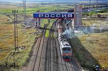
There are a number of highway and ferry border crossings on the eastern section of the binational border. There are also two railway crossings, at Zabaikalsk/Manzhouli and Suifenhe/Grodekovo; both are over a century old, brought into existence by the original design of Russia's Transsiberian Railway that took a shortcut across Manchuria (the Chinese Eastern Railway). The third railway crossing, near Hunchun/Makhalino, operated between 2000-2004, but is closed now; plans for its reopening are being considered.[6][7]
As of 2009, there were no border crossings of any kind on the two countries' short and remote western border section.[8]
References
- ↑ 1.0 1.1 Sébastien Colin, Le développement des relations frontalières entre la Chine et la Russie, études du CERI n°96, July 2003.
- ↑ НАЧАЛО РУССКО-КИТАЙСКОГО РАЗГРАНИЧЕНИЯ В ЦЕНТРАЛЬНОЙ АЗИИ. ЧУГУЧАКСКИЙ ПРОТОКОЛ 1864 г.
- ↑ Mueller, Jason: Evolution of the First Strike Doctrine in the Nuclear Era, Volume 3: 1965–1972
- ↑ Burr, W.; Richelson, J. T. (2000–2001). "Whether to "Strangle the Baby in the Cradle": The United States and the Chinese Nuclear Program, 1960-64". International Security 25 (3): 54–99. doi:10.2307/2626706 (inactive 2015-01-09). JSTOR 2626706.
- ↑ Andrew Osborn and Peter Foster, 13 May 2010, USSR planned nuclear attack on China in 1969, Telegraph UK
- ↑ Переход Махалино–Хуньчунь (Makhalino-Hunchun border crossing), 2011-08-12 (Russian)
- ↑ Россия и Китай реанимируют бездействующий погранпереход (Russia and China will revive a defunct border crossing), 20.09.2012 (Russian)
- ↑ See e.g. the apparently exhaustive list of China's border crossing in Xinjiang (新疆边贸口岸信息汇总, 2009-05-07), which includes no crossings on the border with Russia)
External links
| ||||||