Chewacla State Park
| Chewacla State Park | |
|---|---|
|
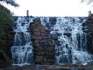
Chewacla Falls in late autumn | |
 Location of Chewacla State Park in Alabama | |
| Type | State park |
| Location | 124 Shell Toomer Parkway, Auburn, Alabama |
| Coordinates | 32°33′14.724″N 85°28′51.06″W / 32.55409000°N 85.4808500°WCoordinates: 32°33′14.724″N 85°28′51.06″W / 32.55409000°N 85.4808500°W |
| Area | 696 acres (282 ha) |
| Elevation | 472 feet (144 m) [1] |
| Operated by | Alabama Department of Conservation and Natural Resources |
Chewacla State Park is a 696-acre (282 ha) state park in Auburn, Alabama. It is located just south of Interstate 85 in Lee County and offers picnicking, hiking, swimming, camping, and lodging.[2]
Activities and amenities
- Lake Chewacla: Lake Chewacla's 26 acres (11 ha) provide opportunities for fishing, swimming, and non-motorized boating.
- Trails: The park offers a mountain bike trail, a tree identification trail, and eight hiking trails of varying degrees of difficulty:[3]
- The Sweet Shrub Trail features interpretative displays; it begins at the Lower Shelter, makes a loop and returns to the Lower Shelter.
- The Boy Scout Trail begins on the west side of the stone bridge and runs into the Sweet Shrub Trail.
- The Troop 30 Boy Scout Trail begins on the north side of the stone bridge on Murphy Drive. This trail follows Moore’s Mill Creek to the boundary of the park. It may be followed to the park boundary or the creek may be crossed on one of the rock dams to follow the trail back to Murphy Drive.
- The Eagle Scout Trail branches off from the Troop 30 Boy Scout Trail on the east side of Chewacla Lake and terminates on the logging road across from the Walnut Shelter.
- The Deer Rub Trail features steep terrain and begins at the Upper Pavilion and follows Chewacla Creek to the Walnut Shelter.
- The Loop Road Trail leads to Chewacla Falls and is a paved trail.
- The Mountain Laurel Trail begins at the Upper Pavilion area, goes down to Chewacla Falls and then follows Chewacla Lake.
- The Mountain Bike Trail loops around the upper portion of Murphy Drive.[3]
- Lodging: In addition to facilities for RV and tent camping, the park has six renovated Civilian Conservation Corps–era stone cabins with hardwood floors, stone fireplaces, bathrooms, TVs, modern kitchens, and central heating and cooling systems. The cabins are available year around and require reservations.[4]
References
- ↑ "Chewacla State Park". Geographic Names Information System. United States Geological Survey.
- ↑ "Chewacla State Park". Alabama State Parks. Alabama Department of Conservation and Natural Resources. Retrieved 2012-11-05.
- ↑ 3.0 3.1 "Chewacla State Park (Trails)". Alabama State Parks. Alabama Department of Conservation and Natural Resources. Retrieved 2012-11-05.
- ↑ "Chewacla State Park (Cabins)". Alabama State Parks. Alabama Department of Conservation and Natural Resources. Retrieved 2012-11-05.
External links
- Chewacla State Park Alabama Department of Conservation and Natural Resources
| ||||||||||||||||||||||||||||||||||||||||||