Chetton
| Chetton | |
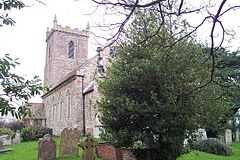 St Giles, Chetton |
|
 Chetton |
|
| Population | 304 |
|---|---|
| OS grid reference | SO6690 |
| District | Bridgnorth District |
| Shire county | Shropshire |
| Ceremonial county | Shropshire |
| Region | West Midlands |
| Country | England |
| Sovereign state | United Kingdom |
| Post town | WOLVERHAMPTON |
| Postcode district | WV16 |
| Police | West Mercia |
| Fire | Shropshire |
| Ambulance | West Midlands |
| EU Parliament | West Midlands |
|
|
Coordinates: 52°30′25″N 2°30′07″W / 52.507°N 2.502°W
Chetton is a small village and civil parish in Shropshire, England.[1] According to the 2001 census the parish had a population of 304.[2] It is about 20 miles (32 km) to the West of Wolverhampton in West Midlands and South of Telford. The parish church has a fine set of church bells[3]
Demographic
Population
Since the 1800s there has been regular data collected regarding the parishes's population. The total population has fluctuated over the years but has actually decreased by 23% over the last 200 years. However, the population has not always decreased. Records show that between 1801 and 1841 the population increased by 46%. In addition to this, in 1911 there was a sudden increase of 9%. Chetton's population does not follow suit of the English population; between 1801 and 1961 the total population of England had steadily increased by 460%. It is not unusual for small civil parishes such as Chetton to have dwindling populations. Many young people living in such areas find it hard to gain employment and social events for the younger generations are limited resulting in many migrating in search of better opportunities in the city.[4]
As the population of England and Wales has increased, so has the population density. Between 1800 and 1960 the population density of England and Wales has increased dramatically. In contrast to this Chetton's population density has not fluctuated at all, if anything it has very slightly decreased.[5]
The most recent Census data available for Chetton is the 2001 census and according to this census the parish had a total of 304 people. This has decreased since the first census data in 1801 where the population was 396. This is a total decrease of 23% since 1801, which for such a small parish is a considerable amount of decrease compared to other towns and villages in Shropshire. At the time of the 2001 census, the total headcount for Chetton was 304, 160 of these were males and 144 were females, with a total of 121 households.[6]
Population Density (Per Acre)
Since the data from the 1881 census was published the population density of Chetton has steadily increased ever since. Compared to the population density of England and Wales which has stayed the same and slightly decreased around the 1900 but then increased soon after.The density changes a lot from one census to another but that was also down the change of map boundaries.[7]
Occupation Structure
Even when the first census was produced it categorised into three categories, 'chiefly employed in agriculture', those 'chiefly employed in trade, manufacturers or handicraft', and 'others'. However, as time went on the censuses became more detailed, data was collected on people's occupations and were then used in the 1841 census whereby there was over 3,000 different occupational titles. This was not practical but at the time there was no advice on how to organise the job titles as they did not expect the vast number of job titles that were given. The 1881 census shows that Chetton was an agricultural parish but it was mainly males working in this sector as it also shows that the majority of the women were unemployed. Some women were employed but it was not in a manual profession, they were employed in a domestic service role or in an office.[8]
Housing
Census data has enabled us to have an insight to the way Chetton used to be. In 1831 the census began to gather more personal information about people's properties, the number of rooms, the number of people living there etc, but the statistical data gathered was the number of people occupying the house and the number of rooms. We are able to use this data and see that there were 123 houses of which 199 of these were occupied.[9] Every census since has asked similar questions. The number of houses in Chetton has fluctuated over the last 200 years but in 1961 the total number of houses had decreased to 180, however, all of these were occupied.[10] Between 1921 and 1961 the number of rooms in Chetton had increased by 3 despite the decrease in houses[11]
The types of houses in Chetton are a mixture of terraced houses, farm houses and detached houses. Many of these houses use to be owned by farmers who used to make their living out of agriculture, whether it would be growing and selling crops such as wheat, oats and grain or farming cattle, sheep or chickens. Chetton was very much an agricultural parish.
Transport
Car
Chetton is accessible by various country lanes but all these roads connect to the B4364 and the B4368. These join the A458 which joins Chetton to the nearest town, Bridgnorth.
Train
There are two main railway stations near Chetton, however, there are no stations in the parish itself. The nearest station is Shifnal railway station located around 11.86 miles away and then Telford Central railway station, 11.91 miles away.
The Opposed Wind Farm
There was a proposal in 2012 to raise two 750kwh Wind turbines across the Jack Mytton Way at Meadowley. At present the proposal is at a public 'consultation' stage with the local community and no concrete planning application to Shropshire Council has been put in yet. The small hamlet of Meadowley is the site for the proposed wind farm; it will be built on top of Meadowley and stretch out across the Jack Mytton Way. This area is one of Shropshire's most famous 'flagship' bridle paths enjoyed by tens of thousands of riders, walkers and bicyclists every year. The proposal states that each turbine will tower 80m high and will stand either side of a rough dirt road that will allow rides, walkers and cyclists to pass directly through the wind farm.[12]
However, the community of Chetton are incredibly concerned about the proposed wind farm. They believe that it will 'degrade' the local historic landscape. There have been huge campaigns to prevent the development in the area as they also believe that judging by past experiences elsewhere around Britain it could turn the parishes from Chetton to Morville and Upton Cressett into an unsightly forest of turbines.[12]
Notes
- ↑ Genuki details
- ↑ Census data
- ↑ Enthusiasts web-site
- ↑ "Vision of Britain". University of Portsmouth. Retrieved 7 March 2012.
- ↑ "Vision of Britain". University of Portsmouth. Retrieved 7 March 2012.
- ↑ "Neighbourhood Statistics – Chetton". Retrieved 7 March 2012.
- ↑ "Vision of Britain". Retrieved 24 April 2012.
- ↑ "Vision of Britain". Retrieved 24 April 2012.
- ↑ "Vision of Britain". University of Portsmouth. Retrieved 7 March 2012.
- ↑ "Vision of Britain". University of Portsmouth. Retrieved 7 March 2012.
- ↑ "Vision of Britain". University of Portsmouth. Retrieved 7 March 2012.
- ↑ 12.0 12.1 "Stop Bridgenorth Wind Farm". Retrieved 7 March 2012.
External links
![]() Media related to Chetton at Wikimedia Commons
Media related to Chetton at Wikimedia Commons
| ||||||||||||||||||||||