Chesterton, Huntingdonshire

Coordinates: 52°32′N 0°20′W / 52.54°N 0.34°W
Chesterton – in Huntingdonshire (now part of Cambridgeshire), England – is a village near Alwalton west of Yaxley. Chesterton is located 8 miles east of Peterborough. In the 17th Century, Chesterton was the home of John Dryden's family, who lived in Chesterton manor.[1]
In the 1870s, Chesterton was described as
- "a parish in the district of Peterborough and county of Huntingdon; on the verge of the county, and on Ermine-street and the river Nen, 2½ miles SE of Castor r. station, and 5½ SW of Peterborough. Post town, Castor, under Peterborough. Acres, 1, 330. Real property, £2, 447. Pop., 129. Houses, 22.[2]"
History
- Chesterton is rich in Roman history, with the name Chesterton meaning "Roman site farm/settlement[3]". MR A. Guest presents the Romans appearance as impressive, when he states "The Roman colonisation of the parish was impressive. Their first appearance was military, a five acre fort at Water Newton on the North border of Chesterton, which was built in the mid first century to guard the crossing of the Nene. A Civil settlement soon appeared at the gates of the fort, this became Chesterton with its North and West boundary being the River Nene and Billings Brook respectively. Durobrivae was contained within this boundary, with a Roman Signal Station at its highest point near its Southern border."[4] Another Roman feature in Chesterton is Chesterton mound, which is described as a 'Roman earthen barrow situated 380m north of Hill Farm on the crest of Chesterton Hill south of the remains of the Roman town Durobrivae.[5] "There have been suggestions that the mound was used as a "Roman signal station and a Medieval beacon.[6]"
- After the Romans left Chesterton, the village was drastically reduced in size with the Doomsday book, written in 1086, realving there were "a Lordship in two ploughs, 10 villagers and two smallholders who have three ploughs, a Church and a Priest."[7]

- St Michael's church, which is located on the north side of the village[8] dates back to the 13th Century and has monuments of the Lord of the Chesterton Manor, which belonged to the Beville family.[9] Also St Michael's is where the tomb of William Beville who died in 1487 is located.[10] The Beville family built Chesterton manor in the 1600s with Robert Beville building the manor, However the family acquired the land in which the manor was built in 1378 after "the Norman Conquest" and the marriage of John Beville and Agnes Walderchef, until the manor was passed onto to the Dryden family at a later date.[11]
- In 1933 Chesterton had electricity. However piped water was not installed into the village until 1939, which meant villagers had to use water from the local Billing Brook. This eventually led to a sewage system being completed in 1969.[12]
Demographics
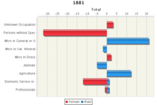
The occupational data of Chesterton in 1881, shown in the graph to the right, presents the majority of females as not having a " Specified Occupation". Compare this to the side which presents data for the male population in Chesterton in 1881, it presents all of the males within the village being in some sort of recognised occupation.[13]
:According to the 2011 Census, Chesterton had a population of 317,[14] with their main industry being in the Wholesale and Retail Trade.[15] Compare this to the Chesterton of 1831, where the population was only 105[16] and 66% of the industry in Chesterton was in the agricultural industry.:[17] In 2011, the total number of households in Chesterton was 139.[18] This compared to the number of households in the village in 1831, which was 21 households [19] shows clear signs of development in the village to increase the number of households. The population density in Chesterton was measured at 0.2 (Numbers of people per hectare) in the 2011 Census. This is seen to be drastically under the national average in England which is 4.1 ( Numbers of people per hectare).[20] Also in Chesterton, the percentage of people who stated their religion as Christian in the 2011 Census was also higher than the national average, with the percentage of the population who were Christians in Chesterton at 75.7% and the national average in England being 59.4%.[21]
Education
Chesterton has no schools in the village itself. However it has several schools located within the local area. It has 2 primary schools located within a radius 1.5 miles from the village. These schools are Orton Wistow Primary School and Matley Primary School. Both these schools are for children aged 4–11 years old.[22] An Ofsted report in 2011 gave Orton Wistow primary school a rating of "Good." [23] An Ofsted report in 2013 for Matley Primary school rated the school as "Requires Improvement."[24] The nearest secondary school is located 1.4 miles away from the village and is called Ormiston Bushfield Academy. The school is for children aged 11– 19 years old.[25] An Ofsted report in May 2012 rated the school as "Good"[26]
References
- ↑ "Chesterton: Huntingdonshire District Council". Town and Parishes. Huntingdonshire District Council. Retrieved 19 February 2014.
- ↑ Wilson, John Marius (1870–72). Imperial Gazetteer of England and Wales (1870-72). Edinburgh: A.Fullarton & Co.
- ↑ "Chesterton- Key to English Place-names". Chesterton- Key to English Place-names. University of Nottingham. Retrieved 27 February 2014.
- ↑ "Chesterton: Pre 1800 History". Pre 1800 History. Robin Peel. Retrieved 24 March 2014.
- ↑ "Gatehouse- Gazetteer: Chesterton Mound". Gatehouse- Gazetteer. Gatehouse- Gazetteer. Retrieved 24 February 2014.
- ↑ "Gatehouse- Gazetteer: Chesterton Mound". Gatehouse- Gazetteer. Gatehouse- Gazetteer. Retrieved 24 February 2014.
- ↑ "Chesterton: History Pre 1800". Chesterton: History Pre 1800. Robin Peel. Retrieved 24 March 2014.
- ↑ "Parish Church of St Michael, Chesterton". Parish Church of St Michael, Chesterton. English Heritage. Retrieved 25 March 2014.
- ↑ "POST ROMAN TIMES UNTIL 1800.". POST ROMAN TIMES UNTIL 1800. Robin Peel. Retrieved 25 March 2014.
- ↑ "POST ROMAN TIMES UNTIL 1800.". POST ROMAN TIMES UNTIL 1800. Robin Peel. Retrieved 25 March 2014.
- ↑ "Chesterton: Pre 1800 History: Post Roman times until 1800". Post Roman times until 1800. Robin Peel. Retrieved 26 March 2014.
- ↑ "Chesterton: More Modern times". More Modern times. Robin Peel. Retrieved 26 March 2014.
- ↑ "Chesterton CP/AP through time". Industry Statistics. Vision of Britain. Retrieved 27 April 2014.
- ↑ "Chesterton (parish) Key figure for 2011 Census: Key Statistics". Neighbourhood statistics. Office for National Statistics. Retrieved 25 March 2014.
- ↑ "Chesterton (parish) Key figures for 2011 Census: Industry 2011". Neighbourhood Statistics. Office for National Statistics. Retrieved 25 March 2014.
- ↑ "Historical Statistics". Historical Statistics: Population. Vision of Britain. Retrieved 25 March 2014.
- ↑ "Historical Statistics". Historical Statistics: Industry. Vision of Britain. Retrieved 25 March 2014.
- ↑ "Chesterton (parish): Key figures for 2011 Census: Household composition". Neighbourhood Statistics. Office for National Statistics. Retrieved 25 March 2014.
- ↑ "Historical Statistics: Housing". Historical Statistics. Vision of Britain. Retrieved 25 March 2014.
- ↑ "Chesterton (parish): Housing: Population Density". Neighbourhood Statistics. Office for National Statistics. Retrieved 26 March 2014.
- ↑ "Chesterton (parish): Key Figures for 2011 Census: Key Statistics". Neighbourhood Statistics. Office for National Statistics. Retrieved 26 March 2014.
- ↑ "School finder". School finder: Primary schools. RM at Home. Retrieved 25 March 2014.
- ↑ "Orton Wistow Primary school: Ofsted report". Ofsted report. Orton Wistow Primary school. Retrieved 25 March 2014.
- ↑ "Peterborough primary school announces academy plan". Peterborough primary school announces academy plan. David Seymour. Retrieved 25 March 2014.
- ↑ "School finder". School finder: Secondary schools. RM at Home. Retrieved 25 March 2014.
- ↑ "Ormiston Bushfield Academy celebrates good Ofsted inspection". Opportunity Peterborough: News. Opportunity Peterborough. Retrieved 25 March 2014.
External links
![]() Media related to Chesterton, Huntingdonshire at Wikimedia Commons
Media related to Chesterton, Huntingdonshire at Wikimedia Commons