Chertsey, Quebec
| Chertsey | |
|---|---|
| Municipality | |
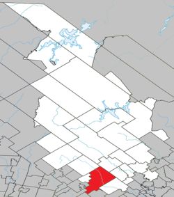
 Location within Matawinie RCM. | |
 Chertsey Location in central Quebec. | |
| Coordinates: 46°10′N 73°55′W / 46.167°N 73.917°WCoordinates: 46°10′N 73°55′W / 46.167°N 73.917°W[1] | |
| Country |
|
| Province |
|
| Region | Lanaudière |
| RCM | Matawinie |
| Constituted | November 13, 1991 |
| Government[2] | |
| • Mayor | Jocelyn Gravel |
| • Federal riding | Joliette |
| • Prov. riding | Rousseau |
| Area[2][3] | |
| • Total | 301.70 km2 (116.49 sq mi) |
| • Land | 287.36 km2 (110.95 sq mi) |
| Population (2011)[3] | |
| • Total | 4,836 |
| • Density | 16.8/km2 (44/sq mi) |
| • Pop 2006-2011 |
|
| • Dwellings | 4,309 |
| Time zone | EST (UTC−5) |
| • Summer (DST) | EDT (UTC−4) |
| Postal code(s) | J0K 3K0 |
| Area code(s) | 450 and 579 |
| Highways |
|
| Website |
www |
Chertsey is a municipality in the regional county municipality of Matawinie in Quebec, located in the administrative region of Lanaudière.
The diocesan shrine Mary Queen of Hearts (Marie-Reine-des-Coeurs) is in Chertsey.[4]
Lake Beaulac, the lake with the highest elevation in Lanaudière, was annexed by the municipality in 1991.
Demographics
Population
| Historical Census Data - Chertsey, Quebec[5] | ||||||||||||||||||||||||||
|---|---|---|---|---|---|---|---|---|---|---|---|---|---|---|---|---|---|---|---|---|---|---|---|---|---|---|
|
|
| ||||||||||||||||||||||||
Private dwellings occupied by usual residents: 2,351 (total dwellings: 4,309)
Language
Mother tongue:[6]
- English as first language: 3.2%
- French as first language: 94.4%
- English and French as first language: 0.8%
- Other as first language: 1.6%
See also
References
- ↑ Reference number 269410 of the Commission de toponymie du Québec (French)
- ↑ 2.0 2.1 Geographic code 62047 in the official Répertoire des municipalités (French)
- ↑ 3.0 3.1 Statistics Canada 2011 Census - Chertsey census profile
- ↑ Sanctuaire diocésain Marie-Reine-des-Coeurs
- ↑ Statistics Canada: 1996, 2001, 2006, 2011 census
- ↑ Statistics Canada 2006 Census - Chertsey community profile
External links
- (French) Municipalité de Chertsey
 |
Notre-Dame-de-la-Merci | Saint-Côme |  | |
| Entrelacs Sainte-Marguerite-du-Lac-Masson Estérel |
|
Saint-Alphonse-Rodriguez | ||
| ||||
| | ||||
| Sainte-Adèle, Saint-Hippolyte | Saint-Calixte | Rawdon |
| ||||||||||||||||||