Cheney Reservoir
| Cheney Reservoir | |
|---|---|
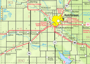 2005 KDOT Map of Reno County, Kansas | |
| Location |
Sedgwick / Kingman / Reno counties |
| Type | Reservoir |
| Basin countries | United States |
| Built | 1965 |
| Settlements |
Cheney, St. Joe, Mount Vernon |
Cheney Reservoir is a reservoir on the Ninnescah River in Reno, Kingman, and Sedgwick counties of Kansas in the United States. Most of it is located in Reno County. The reservoir has a water surface of 9,500 acres, 7,400 land acres, about 67 miles of shoreline, and a maximum capacity of 124,740 acre-feet.[1][2] Recreation includes a significant amount of sailing, fishing (for crappie, catfish, and striped bass), hunting, boating, camping and hiking.[3] The reservoir lies mostly in Reno County, and borders Cheney State Park, Cheney Wildlife Area, and Blue River Wildlife Area.
The reservoir is formed by Cheney Dam (National ID # KS00017). The middle portion of Cheney Dam lies in the northwest corner of Sedgwick County, Kansas. Its western end lies in Kingman County, and its eastern end lies in Reno County. The earthen dam was constructed between 1962 and 1965 by the United States Bureau of Reclamation, with a height of 126 feet and a length of 24,458 feet at its crest.[4]
The dam impounds the Ninnescah River of Kansas for flood control and municipal water supply as part of the larger Wichita Project. The dam and reservoir are owned and operated by the Bureau. The dam stands at the three-way intersection of Kingman, Reno, and Sedgwick Counties, with portions of the dam lying in all three.
See also
References
- ↑ http://www.recreation.gov/recAreaDetails.do?contractCode=NRSO&recAreaId=124&agencyCode=129
- ↑ http://www.usbr.gov/gp-bin/arcweb_cheney.pl
- ↑ http://www.recreation.gov/recAreaDetails.do?contractCode=NRSO&recAreaId=124&agencyCode=129
- ↑ http://www.usbr.gov/projects/Facility.jsp?fac_Name=Cheney+Dam&groupName=Dimensions
External links
| Wikimedia Commons has media related to Cheney Reservoir. |
- Official
- Cheney Reservoir, US Dept of Interior
- Maps