Chelsfield
Coordinates: 51°21′29″N 0°07′40″E / 51.358155°N 0.127800°E
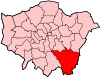
Chelsfield is a large village in Greater London, England within the London Borough of Bromley. It is located near the border of Greater London with Kent bordering the Sevenoaks District. It is located south east of Orpington.
History
The name is recorded in the Domesday Book of 1086 as Cillesfelle, meaning land of a man called Cēol.[1]
It formed an ancient parish, and later civil parish of 3,378 acres (14 km2), in Kent.[2] It was part of the Bromley Rural District from 1894.[2] The parish included Green Street Green and Pratt's Bottom and stretched as far as Cudham and Orpington.[2] The parish was abolished in 1934 and its former area became part of the Orpington parish and urban district.[3] In 1965 it was transferred to Greater London, to form part of the London Borough of Bromley.[3]
Transport
Chelsfield station serves the area with services to London Charing Cross via Grove Park and to Sevenoaks. Chelsfield is served by two Transport for London bus services, the R1 with services to St Pauls Cray via Orpington and to Green Street Green, also the R3 with services to Locksbottom via Petts Wood and Orpington.
Nearest Places
- Pratts Bottom
- Orpington
- Green Street Green
- St Mary Cray
- Halstead
- Farnborough
- St Pauls Cray
- Petts Wood
- Crockenhill
- Eynsford
- Knockholt
- Downe
- Locksbottom
- Swanley
- Foots Cray
- Cudham
References
- ↑ Mills, A., Oxford Dictionary of London Place Names, (2001)
- ↑ 2.0 2.1 2.2 Vision of Britain - Chelsfield parish (historic boundaries)
- ↑ 3.0 3.1 Vision of Britain - Orpington parish