Chelmorton
Coordinates: 53°13′36″N 1°49′59″W / 53.2266°N 1.8330°W
| Chelmorton | |
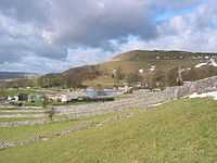 Chelmorton from Midshires Way |
|
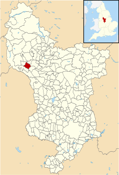 Chelmorton parish highlighted within Derbyshire |
|
| District | Derbyshire Dales |
|---|---|
| Shire county | Derbyshire |
| Region | East Midlands |
| Country | England |
| Sovereign state | United Kingdom |
| Post town | BUXTON |
| Postcode district | SK17 |
| Dialling code | 01298 |
| Police | Derbyshire |
| Fire | Derbyshire |
| Ambulance | East Midlands |
| EU Parliament | East Midlands |
| UK Parliament | Derbyshire Dales |
|
|
Chelmorton (Old English Ceolmaer's hill[1]) is a village in the Peak National Park, the Derbyshire Dales and the White Peak. The village is often described as linear with medieval strip fields radiating horizontally from a main street, rising up a gradual hill.
The parish church of Saint John the Baptist is 11th century.[2] At the opposite end of the village stands its oldest dwelling, Townend Farm, built originally by Isaiah Buxton in 1634. With its four Venetian windows and pedimented doorway it is also known locally as Chelmorton Hall. This ancestral home and family seat of the Marsden[3] family has an enclosed courtyard with elaborate outbuildings. The Church Inn is at the bottom of Chelmorton Low. Other sites of interest are the Rakes, and the source of the village's traditional water supply, Illy Willy Water.
The village is located between Bakewell and Buxton. Children from Chelmorton go to Harpur Hill Primary School, Buxton Community School, Monyash Primary School and Lady Manners School.
References
- ↑ "Chelmorton". Key to English Place-names. English Place Name Society at University of Nottingham. Retrieved 18 August 2013.
- ↑ Pevsner, Nikolaus. 1986. The Buildings of England: Derbyshire. page 140. Harmondsworth, Middx. Penguin.
- ↑ Burke's Aristocractic Families of England. "Burke's Peerage". Burke's Peerage and Gentry. Retrieved 23 May 2011.
External links
![]() Media related to Chelmorton at Wikimedia Commons
Media related to Chelmorton at Wikimedia Commons