Chedburgh
| Chedburgh | |
 All Saints' Church |
|
 Chedburgh |
|
| Population | 650 [1] |
|---|---|
| District | St Edmundsbury |
| Shire county | Suffolk |
| Region | East |
| Country | England |
| Sovereign state | United Kingdom |
| Post town | Bury St Edmunds |
| Postcode district | IP29 |
| Police | Suffolk |
| Fire | Suffolk |
| Ambulance | East of England |
| EU Parliament | East of England |
Coordinates: 52°11′20″N 0°37′01″E / 52.189°N 0.617°E
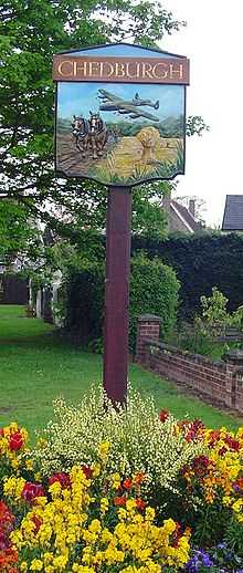
Chedburgh is a village and civil parish in the St Edmundsbury district of Suffolk in eastern England. Located on the A143 around five miles south-west of Bury St Edmunds, in 2005 its population was 650.[1]
On 7 September 1942 South of the Bury Road, RAF Chedburgh opened, in No. 3 Group RAF Bomber Command. Major construction work was carried out by John Laing & Son Ltd., and built to Class A standard, the airfield had three concrete runways, 05-23 at 2,000 yards and 12-30 and 17-35 both at 1,400 yards. In October 1942 214 Squadron moved in flying Short Stirling bombers. Various squadrons followed until December 1946. The airfield site was sold in October 1952, although some hangars were still visible in the 1970s.[2][3] The Bury Road Business Park is located on the former technical site.
References
- ↑ 1.0 1.1 Estimates of Total Population of Areas in Suffolk Suffolk County Council
- ↑ Bowyer, M.J.F. Action Stations: Wartime military airfields of East Anglia 1939-1945 vol. 1. Cambridge, Cambridgeshire, Patrick Stephens Ltd, 1979. ISBN 0-85059-335-2.
- ↑ Wikimapia, Former RAF Chedburgh
External links
![]() Media related to Chedburgh at Wikimedia Commons
Media related to Chedburgh at Wikimedia Commons