Chaumeil
| Chaumeil | ||
|---|---|---|
|
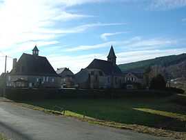
The town hall and the church in Chaumeil | ||
| ||
 Chaumeil | ||
|
Location within Limousin region  Chaumeil | ||
| Coordinates: 45°27′25″N 1°52′57″E / 45.4569°N 1.8825°ECoordinates: 45°27′25″N 1°52′57″E / 45.4569°N 1.8825°E | ||
| Country | France | |
| Region | Limousin | |
| Department | Corrèze | |
| Arrondissement | Tulle | |
| Canton | Corrèze | |
| Intercommunality | Les Monédières | |
| Government | ||
| • Mayor (2008–2014) | Jean-Pierre Kuttig | |
| Area1 | 31.7 km2 (12.2 sq mi) | |
| Population (2008)2 | 161 | |
| • Density | 5.1/km2 (13/sq mi) | |
| INSEE/Postal code | 19051 / 19390 | |
| Elevation | 524–911 m (1,719–2,989 ft) | |
|
1 French Land Register data, which excludes lakes, ponds, glaciers > 1 km² (0.386 sq mi or 247 acres) and river estuaries. 2 Population without double counting: residents of multiple communes (e.g., students and military personnel) only counted once. | ||

Chaumeil is a commune in the Corrèze department in central France.
Population
| Historical population | ||
|---|---|---|
| Year | Pop. | ±% |
| 1962 | 236 | — |
| 1968 | 325 | +37.7% |
| 1975 | 270 | −16.9% |
| 1982 | 218 | −19.3% |
| 1990 | 188 | −13.8% |
| 1999 | 192 | +2.1% |
| 2008 | 161 | −16.1% |
See also
References
| Wikimedia Commons has media related to Chaumeil. |