Chatsworth, Los Angeles
| Chatsworth | |
|---|---|
| Neighborhood of Los Angeles | |
 Chatsworth neighborhood as mapped by the Los Angeles Times | |
 Chatsworth Location within Los Angeles/San Fernando Valley | |
| Coordinates: 34°15′26″N 118°36′04″W / 34.25722°N 118.60111°W | |
| Country |
|
| State |
|
| County |
|
| City |
|
| Elevation | 298 m (978 ft) |
| Population (2000)[1] | |
| • Total | 41,255 |
| Time zone | PST (UTC-8) |
| • Summer (DST) | PDT (UTC-7) |
| ZIP code | 91311 |
| Area code(s) | 818 |
Chatsworth is a neighborhood in the northwestern San Fernando Valley region of Los Angeles, California.
Originally the area was home to Native Americans, some of whom left caves containing rock art, Chatsworth was explored and colonized by the Spanish beginning in the 18th Century. The land was part of a Mexican land grant in the 19th Century, and after the United States took over the land following the Mexican War, it was the largest such grant in California. Settlement and development followed.
Chatsworth has seven public and eight private schools. There are large open-space and smaller recreational parks as well as a public library and a transportation center. Distinctive features are the former Chatsworth Reservoir, the Santa Susana Field Laboratory and a number of private businesses.
Population
The 2000 U.S. census counted 35,073 residents in the 15.24-square-mile Chatsworth neighborhood—or 2,301 people per square mile, among the lowest population densities for both the city and the county. In 2008, the city estimated that the population had increased to 37,102. In 2000 the median age for residents was 40, considered old for city and county neighborhoods; the percentages of residents aged 35 and older were among the county's highest.[2]
The neighborhood was considered "moderately diverse" ethnically within Los Angeles, with a relatively high percentage of whites and of Asian people. The breakdown was Whites, 65.7%; Latinos, 13.5%; Asians, 14.4%; Blacks, 2.2%; and others, 4.2%. Korea (10.4%) and the Philippines (9.3%) were the most common places of birth for the 25.2% of the residents who were born abroad—a low figure for Los Angeles.[2]
The median yearly household income in 2008 dollars was $84,456, considered high for the city. The percentages of families that earned more than $40,000 was considered high for the county. Renters occupied 28.9% of the housing stock, and house- or apartment-owners held 71.1%. The average household size of 2.6 people was considered average for Los Angeles.[2]
In 2000 there were 2,933 military veterans, or 10.8% of the population, a high percentage compared to the rest of the city. The percentages of married people were among the county's highest. The rate of 10% of families headed by single parents was low for the city.[2]
Geography
Chatsworth is flanked by:[3][4]
- the Santa Susana Mountains on the north.
- Porter Ranch and Northridge on the east.
- Winnetka, Canoga Park, and West Hills on the south.
- the Simi Hills, and unincorporated Los Angeles County and Ventura County on the west.
- Twin Lakes, a community founded by San Francisco's George Haight in the early 20th Century and unincorporated Los Angeles County including a 1,600 acre park with equestrian trails to the North.
Climate
This region experiences hot and dry summers, with average daily high temperatures between 90-100 °F. According to the Köppen Climate Classification system, Chatsworth has a warm-summer Mediterranean climate, abbreviated "Csb" on climate maps.[5]
History
Native Americans
Chatsworth was originally inhabited by the Tongva-Fernandeño, Chumash-Venturaño, and Tataviam-Fernandeño Native American tribes. Native American civilizations had inhabited the Valley for an estimated 8,000 years. Stoney Point is the site of the Tongva Native American settlement of Asha'awanga or Momonga, that was also a trading place with the neighboring Tataviam and Chumash people.[6][7] The nearby Burro Flats Painted Cave remains a legacy of the Chumash culture's rock art and solstice ceremony spirituality.[8]
Spain and Mexico
The first European explorers came into the Chatsworth area on August 5, 1769, led by the Spanish military leader Gaspar de Portolà. With its establishment in 1797 and subsequent Spanish Land Grant by the King of Spain, Mission San Fernando (Mission San Fernando Rey de España) gained dominion over the San Fernando Valley's lands, including future Chatsworth.

The Native American trail that had existed from the Tongva-Tatavium village called rancheria Santa Susana (Chatsworth) to another village, replaced by Mission San Fernando, became the route for missionaries and other Spanish travel up and down California. It was part of the El Camino del Santa Susana y Simi trail that connected the Valley's Mission, Los Angeles pueblo (town), and the southern missions with the Mission San Buenaventura, the Presidio of Monterey, and the northward missions. The trail crossed over the Santa Susana Pass to the Simi Valley, through present day city park Chatsworth Park South and the Santa Susana Pass State Historic Park. In 1795, the Spanish land grant had been issued for Rancho Simi, reconfirmed in 1842 by the Mexican governor.[9][10][11] Its lands included part of current Chatsworth, westward from Andora Avenue.
In 1821, after the Mexican War of Independence from Spain, the Mission San Fernando became part of Alta California, Mexico. In 1834, the Mexican government began redistributing the mission lands. In 1846, the Mexican land grant for Rancho Ex-Mission San Fernando was issued by Governor Pío Pico. It was bounded on the north by Rancho San Francisco and the Santa Susana Mountains, on the west by the Simi Hills, on the east by Rancho Tujunga, and on the south by the Montañas de Portesuelo (Santa Monica Mountains). The Rancho Ex-Mission San Fernando received a Federal land patent to retain ownership by the United States Public Land Commission in 1873 and was the single largest land grant in California.[12]
United States
.jpg)
In 1869, the grantee's son, Eulogio F. de Celis, returned from Spain to Los Angeles.[13] In 1874, the family sold their northern half of Rancho Ex-Mission San Fernando to northern Californians, California State Senator Charles Maclay and his partners George K. Porter, a San Francisco shoe manufacturer, and his brother Benjamin F. Porter. The Porters’ land was west of present day Sepulveda Boulevard including most of Chatsworth, and the Maclay land was east of Sepulveda Boulevard.[14]
The Old Santa Susana Stage Road or Santa Susana Wagon Road continued in use as an alternative to the route along El Camino Viejo from 1861 to 1875, replacing the older road as the main route between Los Angeles and San Francisco. In 1876, the Southern Pacific Railroad opened a tunnel through the Newhall Pass, enabling rail connections from Los Angeles north to San Francisco, and rail travel soon replaced travel by stagecoach between Los Angeles and San Francisco. From this time, the stagecoach traffic to Santa Barbara once again used the coast route, and the Santa Susana Pass road was relegated to local traffic.[15]
A new wagon route bypassing the deteriorating Devil's Slide was opened in 1895. Initially called El Camino Nuevo (the New Road), it was later named the Chatsworth Grade Road, which continued in use until Santa Susana Pass Road (now Old Santa Susana Pass Road) was built in 1917.[15]
Government and infrastructure
The Chatsworth Branch Library, operated by the Los Angeles Public Library, is located at 21052 Devonshire Street.[16] It was rebuilt in a modern style in 2002.[17]
The Chatsworth Post Office, of the United States Postal Service, is located at 21606 Devonshire Street.[18]
The U.S. Census Bureau operates the Los Angeles Regional Census Center in Chatsworth.[19][20]
Transportation
The Chatsworth Transportation Center and train station is a major transportation hub for the town and West Valley. It is served by 20 daily trains on the Metrolink Ventura County Line from Ventura to Union Station in Downtown Los Angeles, and by the Amtrak California Pacific Surfliner, with 10 trains up and down the state daily.[21] The Coast Line for freight transport by Union Pacific Railroad also uses the tracks, and was involved in the 2008 Chatsworth train collision.
The Orange Line of the Los Angeles Metro system was extended to Chatsworth Station in 2012, with a dedicated right-of-way across the Valley to North Hollywood Station of the Red Line subway.[22][23][24]
The Chatsworth Transportation Center also offers connections to several Los Angeles Metro, Simi Valley, and Santa Clarita bus routes. It is located at 10046 Old Depot Plaza Road, between Devonshire and Lassen streets.[25]
Education
Thirty-four percent of Chatsworth residents aged 25 and older had earned a four-year degree by 2000, an average percentage for the city.[2]
Schools
Schools within the Chatsworth boundaries are:[26]
Public
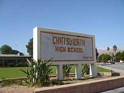
- Chatsworth Senior High School, 10027 Lurline Avenue
- William Tell Aggeler Opportunity High School, 21050 Plummer Street
- Stoney Point Continuation School, 10010 De Soto Avenue
- Ernest Lawrence Middle School, 10100 Variel Avenue
- Germain Street Elementary School, 20730 Germain Street
- Chatsworth Park Elementary School, 22005 Devonshire Street
- Superior Street Elementary School, 9756 Oso Avenue
Private
- Sierra Canyon School, Pre-kindergarten through 12, 20801 Rinaldi Street
- Chatsworth Hills Academy, elementary, 21523 Rinaldi Street
- St. Paul's Christian Academy, 21621 Heather Lee Lane
- Al-Falaq / Me'raj Academy, elementary, 11070 Old Santa Susana Pass Road
- Egremont Schools, Inc., elementary, 19850 Devonshire Street
- Chaminade College Preparatory School, middle, 19800 Devonshire Street
- St. John Eudes, elementary, 9925 Mason Avenue
- Monarch Christian School, 9909 Topanga Canyon Boulevard
Parks and recreation
The City of Los Angeles Parks and Recreation Department, California Department of Parks and Recreation, County of Los Angeles, California State Park Volunteers, and the Santa Monica Mountains Conservancy operate the various natural open space preserve parks and neighborhood recreation parks.
Open-space parks
- Chatsworth Park North — includes more than 20 acres (81,000 m2) of the scenic Simi Hills and is operated by the Los Angeles Parks Department.[27][28] has a baseball diamond, football field, and outdoor basketball courts, all lighted; volleyball courts, a children's play area, hiking trails, a jogging path, and picnic tables with barbecue pits.[29] The park now has fencing that blocks visitors from climbing the large boulder outcrops, but Stoney Point Park and Chatsworth Park South are nearby for bouldering and rockclimbing.

- Chatsworth Park South — includes more than 100 acres (0.40 km2) of the rocky landmark Simi Hills.[30] Chatsworth Park South is adjacent to the Santa Susana Pass State Historic Park, a 174-acre (0.70 km2) National Register of Historic Places property consisting of historic features and deposits, prehistoric village site remnants, and portions of the Old Santa Susana Stage Road, which was the main route for mail and travelers between Los Angeles and San Francisco from 1861 until the opening of rail connections between the two cities in 1876. The stage route was also declared Los Angeles Historic-Cultural Monument #92 (designated January 5, 1972) and Ventura County Historical Landmark #104 (designated October 21, 1986).[31] The park has miles of horseback, jogging, and hiking trails, picnic tables and barbecue pits, and bouldering outcrops.[32]
- Chatsworth Recreation Center facilities are located within the lower area of Chatsworth Park South, with lighted indoor basketball courts, lighted outdoor basketball courts, a children's play area, an indoor gymnasium, a stage, and lighted tennis courts.[33]
- The Minnie Hill Palmer House, one of the West Valley's historic original homestead houses, is in Chatsworth Park South for visits and the Chatsworth Historical Society archives.
- The park has been closed since February 2008 due to contamination discovered from when the park used to be a shooting range for Roy Rogers.[34]
- "Michael D. Antonovich Park at the Joughin Ranch" - includes over 1600 acres of hiking, equestrian trails, creeks, waterfalls and the site of one of the historic Bannon Quarries. .[35]
- Santa Susana Pass State Historic Park (SSPSHP) — a large natural area adjacent to and above the town's western side.[36] The Santa Susana Pass State Historic Park protects and offers a historical site of the late 19th century, when Chatsworth was on a main thoroughfare for the figures of the American West. Joaquin Murrieta and his bandits hid out in the rocky crevices around Stoney Point. The Old Stagecoach Trail above Chatsworth to the west, is now a popular hiking trail in the Simi Hills. It goes through Santa Susana Pass State Historic Park and Chatsworth Park South and by Chatsworth Oaks Park. The State Park is open to the public with several parking and trailhead areas and many hiking and view opportunities.[37]
- Chatsworth Oaks Park — an approximately 3-acre (1.2 ha) natural open space park. It has barbecue pits, a children's play area, and picnic tables near the parking area. Visitors may ride bicycles and hike in the park, which has no established trails but links to nearby Santa Susana Pass State Historic Park. The park overlooks the Chatsworth Nature Preserve, with birdwatching opportunities.[38]

- Stoney Point Park — at Stoney Point is a natural rock outcropping, geographic promontory landmark and legendary bouldering and rock climbing location on 76-acre (31 ha). The boulders at Stoney Point Park merge and form alcoves, caves, and dens. The park also has bridle paths, hiking trails, and connections to adjacent parks to the north.[39] Stoney Point is the site of the Tongva settlement named Asha'awanga or Momonga.
- Chatsworth Trails Park — in the Santa Susana Mountains foothills just north of the 118 Freeway with parking at 11200 Mayan Drive. Chatsworth Trails Park has miles of horseback, hiking, and mountain biking trails and is also a hub connecting to the huge Michael D. Antonovich Regional Park at Joughin Ranch, the Indian Springs Open Space Park, and Rocky Peak Park at Rocky Peak.[40] The Rim of the Valley Trail passes through here, with trailhead access.[41]
- Sage Ranch Park — overlooks Chatsworth from its 2,000-foot (610 m) high ridges in the Simi Hills near the Santa Susana Field Laboratory. It is a new open space park at the end of Woolsey Canyon Road. Sage Ranch Park has campsites, walking and hiking trails, and panoramic views of the San Fernando and Simi Valleys.[42]
Neighborhood parks
- Mason Park[43] — offers barbecue pits, lighted and unlighted baseball diamond, children's play area, and picnic tables.[43]
Chatsworth Reservoir
A distinctive feature in Chatsworth is the Chatsworth Dam and reservoir. Originally built in 1918 as part of the Los Angeles Aqueduct system, the property belongs to the Los Angeles Department of Water and Power. Due to increasing concerns of the water quality because of algae plumes and storm water inflow, it was taken out of service in August 1969. After the 1971 San Fernando earthquake additional concerns for seismic safety led to its abandonment by the LADWP as a storage facility. [46] Chatsworth Oaks Park and the Chatsworth Nature Preserve are located here giving views of migrating birds and other animals, and their sounds such as the coyotes calling in the evening. The views of the rocky and dramatic Simi Hills surround the open space.[47]
Chatsworth Reservoir is classified by the Los Angeles Times as a city neighborhood, but "because there are relatively few homes in this area," the Times does not provide separate statistics for it but adds them to Chatsworth.[48] The Devonshire and Topanga stations of the Los Angeles Police Department provide services in the area.[49]
Economy
Chatsworth is the home of the National Notary Association and the headquarters for Premier America (Formerly Litton Federal Credit Union) and Matadors Community Credit Union.
The Santa Susana Field Laboratory (SSFL), once busy with Rocketdyne testing rocket engines and Atomics International doing nuclear research, is quiet and high in the Simi Hills west of Chatsworth.[50] It has been closed and will be undergoing an extensive environmental cleanup, and become an open-space park.[51] The park will permanently add to Chatsworth's scenic backdrop, greenway, and hiking opportunities.[52]
Some current businesses based in Chatsworth are: 3M Corporation, Girl Scouts, Capstone Turbine, Natel Engineering, Hydraulics International, and with Lamps Plus having production and distribution facilities here.
Titus Software's United States subsidiary once had its headquarters in Chatsworth.[53]
Notable residents
- Mike Moustakas, Major League Baseball[54]
- Larry Niven, noted science fiction and fantasy author[55]
- Kevin Spacey, actor; graduated from Chatsworth High School (valedictorian)
- Matt Dominguez,Major League Baseball
- Matt Cassel, NFL
- Bryan Petersen, Major League Baseball
- Candace Cameron Bure, actress
- Kirk Cameron, actor
Cemetery
- Fred Astaire and Ginger Rogers, famed dance team and Hollywood legends, both are buried in Oakwood Memorial Park Cemetery in Chatsworth, as are other motion-picture stars including Gloria Grahame and Stephen Boyd, as well as noted film and cartoon composer, Scott Bradley.
See also
- Lassen Street Olive Trees (Chatsworth, California)
- Old Santa Susana Stage Road
- Burro Flats Painted Cave
- History of the San Fernando Valley to 1915
- List of Los Angeles Historic-Cultural Monuments in the San Fernando Valley
- Von Sternberg house by Neutra
References
- ↑ "Los Angeles Almanac: City of Los Angeles Population by Community & Race 2000 Census". Retrieved April 5, 2010.
- ↑ 2.0 2.1 2.2 2.3 2.4 "Chatsworth," Mapping L.A., Los Angeles Times
- ↑ Colored map, Mapping L.A., Los Angeles Times
- ↑ "Northwest County," Mapping L.A, Los Angeles Times
- ↑ Climate Summary for Chatsworth
- ↑ "Prehistoric milling site found in California." USA Today. March 3, 2006. Updated March 4, 2006. Retrieved on March 22, 2010.
- ↑ Mercury News article
- ↑ Kenneth Lubas (1971-01-31). "Indians Trying To Safeguard Cave Paintings of Ancestors: Mission Tribe Will Ask Rocketdyne To Enclose Historic Works in Glass for Protection Against Any Vandalism". Los Angeles Times.
- ↑ Report of the Surveyor General 1844 - 1886
- ↑ United States. District Court (California : Southern District) Land Case 103 SD
- ↑ Diseño del Rancho Simi
- ↑ C. A. Ensign, 1903, Notes of Litigation on the Title of a Mexican Land Grant, The Michigan Engineer, Volumes 22-25, pp1124-147, Michigan Engineering Society
- ↑ Romantic Day, Pathetic End: Sad Burial of Once Wealthy Scion of Spain, Los Angeles Times, May 26, 1903, Eulogio F. de Celis
- ↑ K. Roderick, 2001, The San Fernando Valley: America’s Suburb, Los Angeles Times, Los Angeles, California, ISBN 978-1-883792-55-8
- ↑ 15.0 15.1 Bevill, Arthur D. (2007). Santa Susana Pass State Historic Park Cultural Resource Survey Historic Overview (PDF).
- ↑ "Chatsworth Branch Library." Los Angeles Public Library. Retrieved on December 6, 2008.
- ↑ "." Los Angeles Times. Retrieved on April 6, 2012.
- ↑ "Post Office Location - CHATSWORTH." United States Postal Service. Retrieved on December 6, 2008.
- ↑ "The Los Angeles Region." U.S. Census Bureau. Retrieved on January 17, 2010.
- ↑ "Boundary Map." Chatsworth Neighborhood Council. Retrieved on January 17, 2010.
- ↑ Metrolink website
- ↑ Orange Line website
- ↑ Orange Line website
- ↑ Metro Net website
- ↑ Metrolink website
- ↑ "Chatsworth: Schools," Mapping L.A., Los Angeles Times
- ↑ "Chatsworth Park North". LAMountains.com. Retrieved 2010-02-05.
- ↑ "City of Los Angeles Department of Recreation and Parks". Laparks.org. Retrieved 2013-10-08.
- ↑ "Chatsworth North Park." City of Los Angeles. Retrieved on March 22, 2010.
- ↑ "Chatsworth Park South". LAMountains.com. Retrieved 2010-02-05.
- ↑ "Santa Susana Pass SHP". Parks.ca.gov. Retrieved 2013-10-08.
- ↑ "Chatsworth Park South." City of Los Angeles. Retrieved on March 22, 2010.
- ↑ "Chatsworth Recreation Center." City of Los Angeles. Retrieved on March 22, 2010.
- ↑ Schrader, Tina (2010-09-28). "Park Tainted by Lead from Roy Rogers' Days May Reopen - Government - Northridge-Chatsworth, CA Patch". Northridge.patch.com. Retrieved 2013-10-08.
- ↑ "Michael D. Antonovich at the Joughin Ranch". LAMountains.com. Retrieved 2015-01-05.
- ↑ State Park=SSPSHP
- ↑ l.a.Parks: SSPSHP Hikes + Trails Map
- ↑ "Chatsworth Oaks Park." City of Los Angeles. Retrieved on March 22, 2010.
- ↑ "Stoney Point Park." City of Los Angeles. Retrieved on March 22, 2010.
- ↑ Michael D. Antonovich Regional Park at Joughin Ranch
- ↑ National Park Service
- ↑ LAMountains.com
- ↑ 43.0 43.1 "Mason Park." City of Los Angeles. Retrieved on October 21, 2013.
- ↑ "Mason Recreation Center." City of Los Angeles. Retrieved on March 22, 2010.
- ↑ "Mason Child Care Center." City of Los Angeles. Retrieved on March 22, 2010.
- ↑ Rogers, J. David (2012). "DAMS AND DISASTERS: a brief overview of dam building triumphs and tragedies in California’s past" (PDF). University of California Davis. p. 51. Retrieved 2013-10-30.
- ↑ Chatsworth Nature Preserve
- ↑ "Chatsworth Reservoir," Mapping L.A., Los Angeles Times
- ↑ "Crime: Chatsworth Reservoir," Mapping L.A., Los Angeles Times
- ↑ ACME-SSFL info site
- ↑ Santa Susana Field Lab
- ↑ SSFL forum
- ↑ "Contact." Titus Interactive. 3 June 2004. Retrieved on 4 September 2012.
- ↑ "Chatsworth Baseball". Chatsworth High School Athletic Department. 2006. Retrieved 4 January 2013.
- ↑ "Known Space: The Future Worlds of Larry Niven". Retrieved 8 January 2014.
External links
| Wikimedia Commons has media related to Chatsworth, Los Angeles. |
- Chatsworth Neighborhood Council
- Chatsworth Historical Society
- California State Parks Dept. - official Santa Susana Pass State Historic Park website
- LAMountains.com - Santa Susana Pass Historic Park hiking website
- official Los Angeles City Parks: Chatsworth Park South website
- Chatsworth crime map and statistics
Coordinates: 34°15′26″N 118°36′01″W / 34.25722°N 118.60028°W
| |||||||||||||||||||||

| |||||||||||||||||