Chato Volcano
| Chato Volcano | |
|---|---|
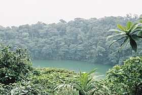 Crater Lake of Cerro Chato | |
| Elevation | 1,140 m (3,740 ft) |
| Location | |
 Chato Volcano | |
| Range | Guanacaste Cordillera |
| Coordinates | 10°26′31″N 84°41′17″W / 10.44194°N 84.68806°WCoordinates: 10°26′31″N 84°41′17″W / 10.44194°N 84.68806°W |
| Geology | |
| Type | Stratovolcano |
| Last eruption | ~3500 years ago |
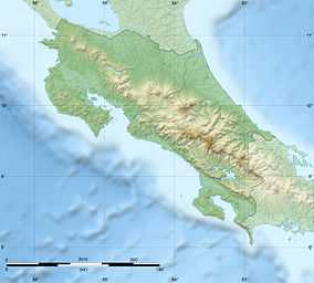
Chato Volcano, sometimes called "Cerro Chato" (Spanish for "Mount Chato"), is an inactive volcano in north-western Costa Rica north-west of San José, in the province of Alajuela, canton of San Carlos, and district of La Fortuna. It is southeast of the nearby Arenal Volcano
It is believed Chato first erupted 38,000 years ago during the Pleistocene period and last erupted about 3,500 years ago. One of the lava flows is now the route for La Fortuna Waterfall. The hill has two peaks, named Chatito and Espina. A crater about 500 metres (1,600 ft) wide is filled with a lagoon, Laguna Cerro Chato.
References
- Profile of Chato Volcano at Costa Rica's Seismic National Network
- Basic limnology of fifty-one lakes in Costa Rica (contains some information on Laguna Cerro Chato)
- "Arena". Global Volcanism Program. Smithsonian Institution.
| ||||||||||||||