Chatenet
| Chatenet | |
|---|---|
 | |
 Chatenet | |
|
Location within Poitou-Charentes region 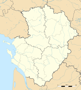 Chatenet | |
| Coordinates: 45°18′09″N 0°18′19″W / 45.3025°N 0.3053°WCoordinates: 45°18′09″N 0°18′19″W / 45.3025°N 0.3053°W | |
| Country | France |
| Region | Poitou-Charentes |
| Department | Charente-Maritime |
| Arrondissement | Jonzac |
| Canton | Montlieu-la-Garde |
| Intercommunality | Haute-Saintonge |
| Government | |
| • Mayor (2008–2014) | Philippe Chailloux |
| Area1 | 9.6 km2 (3.7 sq mi) |
| Population (2008)2 | 220 |
| • Density | 23/km2 (59/sq mi) |
| INSEE/Postal code | 17095 / 17210 |
| Elevation |
61–123 m (200–404 ft) (avg. 85 m or 279 ft) |
|
1 French Land Register data, which excludes lakes, ponds, glaciers > 1 km² (0.386 sq mi or 247 acres) and river estuaries. 2 Population without double counting: residents of multiple communes (e.g., students and military personnel) only counted once. | |
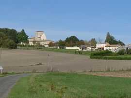
Chatenet is a commune in the Charente-Maritime in the department in the Poitou-Charentes region in southwestern France.
Geography
Chatenet is a small commune situated between the market town of Montendre and the large village of Chevanceaux. It is principally a farming community; however in recent years tourism has become important. The location of Chatenet in the southern tip of the Charente Maritime provides the area with a warm climate. The Seugne flows north-northwestward through the middle of the commune and forms part of its southern and northern borders.
Population
| Historical population | ||
|---|---|---|
| Year | Pop. | ±% |
| 1962 | 268 | — |
| 1968 | 275 | +2.6% |
| 1975 | 215 | −21.8% |
| 1982 | 210 | −2.3% |
| 1990 | 195 | −7.1% |
| 1999 | 188 | −3.6% |
| 2008 | 220 | +17.0% |
See also
References
External links
| Wikimedia Commons has media related to Chatenet. |