Charter Oak Bridge
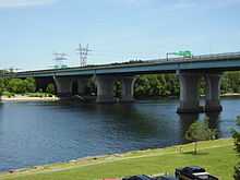
The Charter Oak Bridge is one of the three highway bridges over the Connecticut River in Hartford, Connecticut. The twin steel stringer bridge carries the Wilbur Cross Highway (Route 15/U.S. Route 5) and has an average daily traffic of 79,800.
The original Charter Oak Bridge was constructed in 1940s as part of the Wilbur Cross Highway and allowed through traffic to pass south of downtown Hartford. It was a toll bridge. Due to its obsolescence it was replaced by the current bridge, which is free to motorists.
See also
External links