Charmeil
| Charmeil | |
|---|---|
|
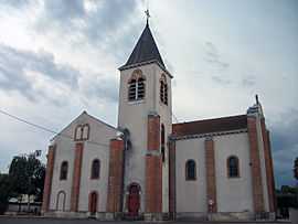
Church | |
 Charmeil | |
|
Location within Auvergne region  Charmeil | |
| Coordinates: 46°09′44″N 3°23′38″E / 46.1622°N 3.3939°ECoordinates: 46°09′44″N 3°23′38″E / 46.1622°N 3.3939°E | |
| Country | France |
| Region | Auvergne |
| Department | Allier |
| Arrondissement | Vichy |
| Canton | Vichy-1 |
| Intercommunality | Vichy Val d'Allier |
| Government | |
| • Mayor (2014–2020) | Franck Gonzales[1] |
| Area1 | 7.4 km2 (2.9 sq mi) |
| Population (2011)2 | 768 |
| • Density | 100/km2 (270/sq mi) |
| INSEE/Postal code | 03060 / 03110 |
| Elevation |
243–311 m (797–1,020 ft) (avg. 220 m or 720 ft) |
|
1 French Land Register data, which excludes lakes, ponds, glaciers > 1 km² (0.386 sq mi or 247 acres) and river estuaries. 2 Population without double counting: residents of multiple communes (e.g., students and military personnel) only counted once. | |
Charmeil is a commune in the Allier department in central France.
Geography
Accessible by departemental roads 6 and 27, Charmeil is located 5 km (around 3 mi) northwest of Vichy, 3 km (around 2 mi) south of Saint-Rémy-en-Rollat, 4 km (around 2.5 mi) east of Vendat, and 4 km (around 2.5 mi) north of Bellerive-sur-Allier.
A weather station is located on the site of the airport (elevation: 249 m, around 800 ft).
-
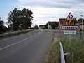
D 27 from Vendat
-
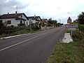
D 27 from Boutiron bridge
Administration
List of successive mayors:
- 2001-2014: Andrée-Claude Petillat
- 2014-current: Franck Gonzales[1]
Population
Demography
| Historical population | ||
|---|---|---|
| Year | Pop. | ±% |
| 1962 | 289 | — |
| 1968 | 306 | +5.9% |
| 1975 | 363 | +18.6% |
| 1982 | 562 | +54.8% |
| 1990 | 564 | +0.4% |
| 1999 | 609 | +8.0% |
| 2008 | 723 | +18.7% |
| 2011 | 768 | +6.2% |
Economy
Charmeil has a commercial area with signs: Mr Bricolage, Jardiland, a Gifi store, Lidl, a Chinese restaurant and local merchants.
Culture and Heritage
- Charmeil Castle, which was the summer residence of Marshal Philippe Pétain in 1943 and which was held including a secret meeting between Pierre Laval and the advisor of German Rudolf Rahn embassy minister in August 1942.
- Church
- Boutiron bridge
See also
References
- ↑ 1.0 1.1 List of mayors of Allier. Retrieved on 2014-10-02
| Wikimedia Commons has media related to Charmeil. |